Download
Preview
Add to list
More
8.2 km
~2 hrs 15 min
367 m
Loop
“Explore lush forests, historic ruins, and panoramic views on the Hohenstaufen trail near Göppingen, Germany.”
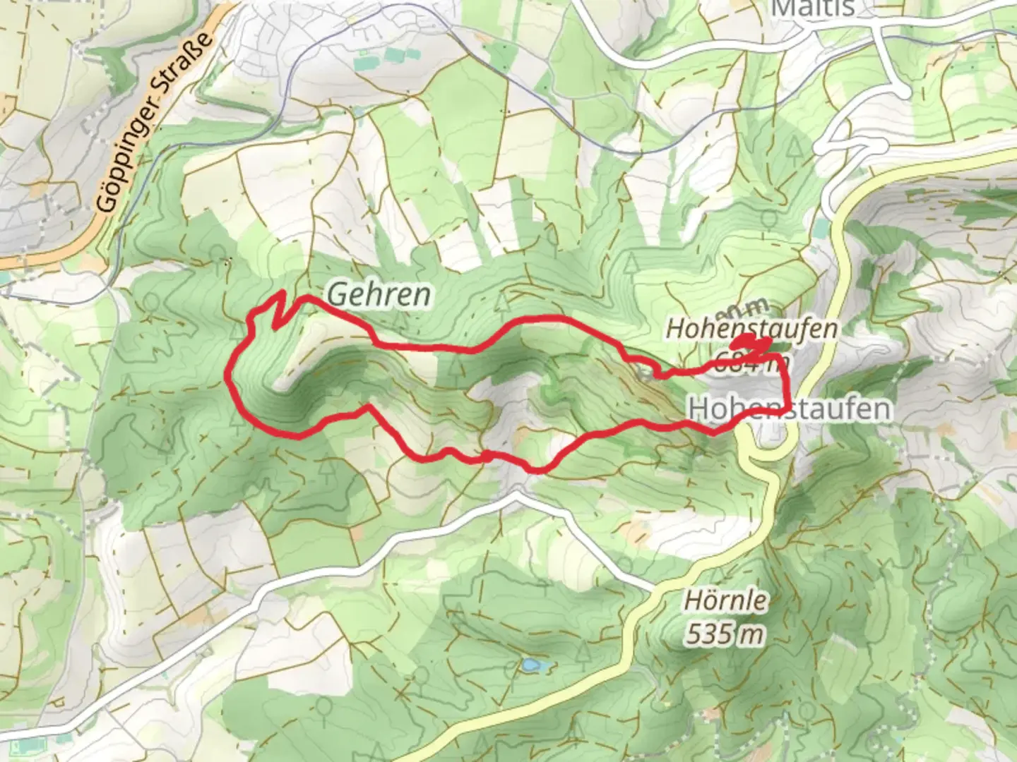
Starting near the charming town of Göppingen, Germany, the Hohenstaufen via Nebenlinie des Sav trail offers an 8 km (approximately 5 miles) loop with an elevation gain of around 300 meters (about 984 feet). This medium-difficulty trail is perfect for those looking to experience a mix of natural beauty and historical intrigue.
Getting There To reach the trailhead, you can either drive or use public transport. If driving, set your GPS to Göppingen, and you’ll find ample parking options near the starting point. For public transport, take a train to Göppingen station, which is well-connected to major cities like Stuttgart. From the station, local buses or a short taxi ride will get you to the trailhead.
Trail Navigation For navigation, it’s highly recommended to use HiiKER, which provides detailed maps and real-time updates. The trail is well-marked, but having a reliable navigation tool ensures you stay on track.
Trail Highlights As you begin your hike, you’ll quickly find yourself immersed in lush forests and rolling hills. The initial part of the trail is relatively gentle, allowing you to warm up before the more challenging sections. About 2 km (1.2 miles) in, you’ll start to notice a gradual incline as you make your way towards the Hohenstaufen mountain.
Historical Significance Hohenstaufen mountain is not just a natural wonder but also a site of historical significance. The mountain is named after the Hohenstaufen dynasty, a prominent royal family in the Holy Roman Empire. As you ascend, you’ll come across the ruins of Hohenstaufen Castle, which dates back to the 11th century. This castle was once the seat of the Hohenstaufen emperors and offers a fascinating glimpse into medieval history.
Flora and Fauna The trail is rich in biodiversity. Keep an eye out for native wildlife such as deer, foxes, and a variety of bird species. The forested areas are home to oak, beech, and pine trees, providing a serene canopy that changes with the seasons. In spring and summer, wildflowers add a splash of color to the landscape.
Midpoint and Views Around the 4 km (2.5 miles) mark, you’ll reach the summit of Hohenstaufen. Here, you’re rewarded with panoramic views of the Swabian Alps and the surrounding countryside. It’s an excellent spot for a break and some photography. There are also informational plaques that provide more context about the historical and natural significance of the area.
Descent and Return The descent begins after you’ve soaked in the views. The trail loops back through a different route, offering new scenery and a gentler decline. This part of the trail is less steep but still requires careful footing, especially if the ground is wet. You’ll pass through more open meadows and small streams, adding variety to your hike.
Final Stretch As you approach the final 2 km (1.2 miles), the trail flattens out, making for a pleasant and easy walk back to the trailhead. This section is a great opportunity to reflect on the hike and enjoy the peaceful surroundings.
Practical Tips - Wear sturdy hiking boots, as some sections can be rocky and uneven. - Bring enough water and snacks, especially if you plan to spend time exploring the castle ruins. - Check the weather forecast before you go; the trail can be slippery after rain. - Use HiiKER for real-time navigation and updates.
This trail offers a perfect blend of natural beauty, historical landmarks, and moderate physical challenge, making it a rewarding experience for any hiker.

What to expect?
Activity types
Comments and Reviews
User comments, reviews and discussions about the Hohenstaufen via Nebenlinie des Sav, Germany.
4.4
average rating out of 5
5 rating(s)