Download
Preview
Add to list
More
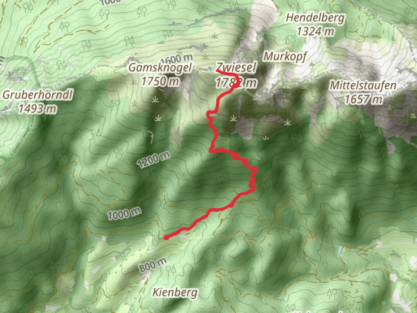
9.1 km
~3 hrs 20 min
911 m
Out and Back
“"Explore the breathtaking Maximiliansweg trail through the Bavarian Alps, a moderately challenging 9 km journey."”
Starting near Berchtesgadener Land, Germany, the Zwiesel via Maximiliansweg trail offers a captivating journey through the Bavarian Alps. This out-and-back trail spans approximately 9 km (5.6 miles) with an elevation gain of around 900 meters (2,953 feet), making it a moderately challenging hike suitable for those with a reasonable level of fitness.### Getting There To reach the trailhead, you can drive or use public transport. If driving, head towards the town of Bad Reichenhall, which is well-connected by road. From there, follow signs to the Zwieselalm parking area. For those using public transport, take a train to Bad Reichenhall station. From the station, local buses can take you closer to the trailhead, with the nearest stop being at the Zwieselalm parking area.### Trail Overview The trail begins at the Zwieselalm parking area, situated near the picturesque town of Bad Reichenhall. As you start your ascent, you'll be greeted by dense forests of spruce and fir, providing ample shade and a serene atmosphere. The initial section of the trail is relatively gentle, allowing you to ease into the hike.### Key Landmarks and Sections - First Kilometer (0-1 km / 0-0.6 miles): The trail starts with a gradual incline through lush forest. Keep an eye out for local wildlife such as deer and various bird species. The forest floor is often carpeted with wildflowers in the spring and summer months.
- Second Kilometer (1-2 km / 0.6-1.2 miles): As you continue, the trail becomes steeper. Here, you'll encounter the first significant elevation gain. The path is well-marked, but it's advisable to use a navigation tool like HiiKER to stay on track. The forest begins to thin out, offering glimpses of the surrounding mountains.- Third Kilometer (2-3 km / 1.2-1.9 miles): This section is characterized by a series of switchbacks that help manage the steep ascent. The views start to open up, revealing the stunning landscape of the Berchtesgadener Land region. Look out for the occasional mountain hut where you can take a short break.- Fourth Kilometer (3-4 km / 1.9-2.5 miles): The trail continues to climb, and you'll reach a small plateau. This is a great spot to rest and enjoy panoramic views of the valley below. The flora changes as you gain altitude, with alpine plants becoming more prevalent.- Final Kilometer to Summit (4-4.5 km / 2.5-2.8 miles): The last stretch to the summit of Zwiesel is the most challenging, with a steep and rocky path. However, the effort is rewarded with breathtaking 360-degree views at the top. On a clear day, you can see as far as Salzburg in Austria.### Historical Significance The region around Berchtesgadener Land is steeped in history. The Maximiliansweg, part of which you will be hiking, is named after King Maximilian II of Bavaria, who was known for his love of the Bavarian Alps. The trail itself has been used for centuries by locals and travelers alike, making it a path rich in cultural heritage.### Descent The descent follows the same path back to the trailhead. While descending, take your time to enjoy the views and perhaps spot some wildlife you might have missed on the way up. The return journey offers a different perspective of the landscape, making it equally enjoyable.### Preparation Tips
- Footwear: Sturdy hiking boots are recommended due to the rocky and uneven terrain, especially near the summit.
- Weather: Weather in the mountains can change rapidly, so bring layers and waterproof gear.
- Hydration and Snacks: Carry enough water and high-energy snacks to keep you fueled throughout the hike.
- Navigation: Use HiiKER to ensure you stay on the correct path, especially in areas where the trail might not be clearly marked.This hike offers a perfect blend of natural beauty, physical challenge, and historical intrigue, making it a must-do for any hiking enthusiast visiting the Bavarian Alps.

What to expect?
Activity types
Comments and Reviews
User comments, reviews and discussions about the Zwiesel via Maximiliansweg, Germany.
4.38
average rating out of 5
8 rating(s)