Download
Preview
Add to list
More
15.3 km
~3 hrs 40 min
370 m
Loop
“Explore the scenic 15 km Buriton Eastern Loop, a moderately challenging trail rich in history and nature.”
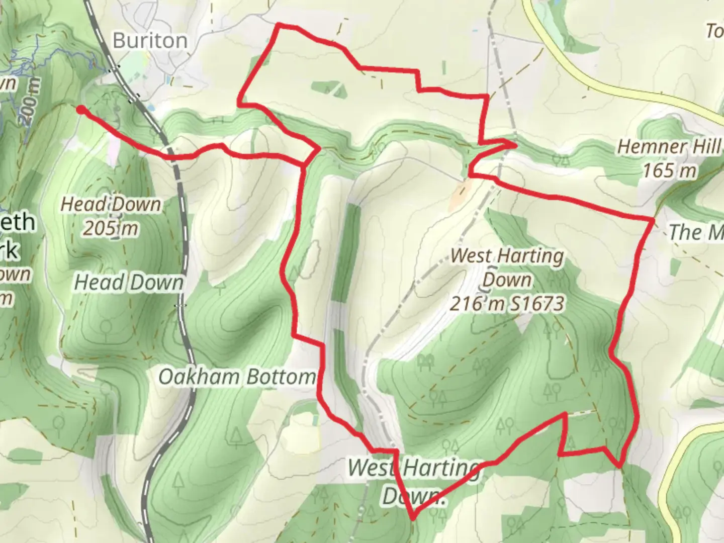
Starting near the charming village of Buriton in Hampshire, England, the Buriton Eastern Loop via West Harting Down is a delightful 15 km (approximately 9.3 miles) loop trail with an elevation gain of around 300 meters (about 984 feet). This trail offers a moderate challenge, making it suitable for hikers with some experience.### Getting ThereTo reach the trailhead, you can drive to Buriton, which is easily accessible from the A3. If you prefer public transport, the nearest train station is Petersfield, located about 4 miles (6.4 km) away. From Petersfield, you can take a taxi or a local bus to Buriton.### Trail OverviewThe trail begins in Buriton, a picturesque village known for its historical significance and beautiful countryside. As you set off, you'll pass through a mix of woodland and open fields, offering a variety of landscapes to enjoy. The initial part of the trail is relatively flat, allowing you to ease into the hike.### Key Landmarks and Points of Interest#### Buriton Chalk PitsAbout 2 km (1.2 miles) into the hike, you'll come across the Buriton Chalk Pits. These old chalk quarries are now a nature reserve, home to a variety of flora and fauna. It's a great spot to take a short break and enjoy the natural beauty.#### West Harting DownAs you continue, you'll reach West Harting Down around the 5 km (3.1 miles) mark. This area is part of the South Downs National Park and offers stunning views of the surrounding countryside. The climb to West Harting Down is one of the more challenging sections of the trail, with a steady ascent that will get your heart pumping.#### Historical SignificanceThe region around Buriton and West Harting Down is steeped in history. The South Downs have been inhabited since prehistoric times, and you may come across ancient burial mounds and other archaeological sites along the way. The area was also significant during the Roman era, and remnants of Roman roads can still be found.### Wildlife and NatureThe trail is rich in biodiversity. Keep an eye out for deer, foxes, and a variety of bird species, including buzzards and kestrels. The woodlands are home to ancient oak and beech trees, and in the spring, the forest floor is often carpeted with bluebells.### Navigation and SafetyGiven the moderate difficulty of the trail, it's advisable to use a reliable navigation tool like HiiKER to ensure you stay on track. The trail is well-marked, but having a digital map can be very helpful, especially in the more remote sections.### Final StretchThe last part of the loop brings you back towards Buriton, descending gradually through more open fields and farmland. This section offers a gentle end to your hike, allowing you to cool down and reflect on the beautiful landscapes you've traversed.### Practical Tips- Wear sturdy hiking boots, as the terrain can be uneven and muddy, especially after rain. - Bring plenty of water and snacks, as there are limited facilities along the trail. - Check the weather forecast before you go, and dress in layers to accommodate changing conditions. - Be mindful of livestock and close any gates you pass through.This trail offers a wonderful mix of natural beauty, historical intrigue, and moderate physical challenge, making it a rewarding experience for any hiker.

What to expect?
Activity types
Comments and Reviews
User comments, reviews and discussions about the Buriton Eastern Loop via West Harting Down, England.
4.0
average rating out of 5
1 rating(s)