Willington to Beachy Head via Windover Hill, Cliff End and Brass Point
Download
Preview
Add to list
More
23.4 km
~1 day 0 hrs
638 m
Point-to-Point
“Follow ancient chalk paths through wildflower meadows to Beachy Head’s dazzling cliffs and timeless views.”
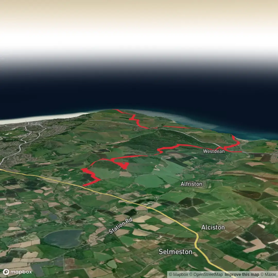
Starting from the village of Willington, just outside Lewes in East Sussex, this 23 km (about 14.3 miles) route with approximately 600 metres (1,970 feet) of elevation gain offers a classic South Downs experience, culminating at the dramatic cliffs of Beachy Head. The trail is best accessed by taking a train to Lewes, then a short local bus or taxi to Willington. For those driving, parking is available in Lewes or at small lay-bys near the village.Rolling Downs and Ancient PathwaysThe initial stretch leads you out of Willington, quickly ascending onto the South Downs Way. Early on, you’ll notice the patchwork of fields and chalk grassland, home to skylarks and rare butterflies like the Adonis blue. The path undulates gently, with the first significant climb taking you up Windover Hill. At around 6 km (3.7 miles), pause to spot the Long Man of Wilmington, a mysterious chalk figure carved into the hillside, believed to date back to at least the 16th century, though its origins remain debated.Windover Hill to Cliff EndContinuing along the ridge, the route offers sweeping views over the Weald to the north and the English Channel to the south. The chalk grassland here is dotted with wildflowers in spring and summer, attracting bees and butterflies. At about 12 km (7.5 miles), you’ll reach Cliff End, where the landscape opens up dramatically. This is a good spot for a break, with panoramic views and the chance to see kestrels hovering above the slopes.Brass Point and the Approach to Beachy HeadThe trail then follows the undulating crest of the Downs, passing Brass Point at around 17 km (10.5 miles). This section is exposed, so be prepared for wind and sudden weather changes. The path is well-trodden but can be muddy after rain. Keep an eye out for grazing sheep and the occasional herd of Sussex cattle, which help maintain the biodiversity of the grassland.Final Stretch: Beachy HeadThe last 6 km (3.7 miles) descend gently before climbing again to the iconic white cliffs of Beachy Head. The lighthouse below and the dramatic drop to the sea make this one of the most photographed spots on the South Coast. The area is rich in history, with evidence of Bronze Age barrows and World War II bunkers along the route. The cliffs are unfenced in places—exercise caution, especially in windy conditions.Navigation and SafetyThe route is mostly well-marked, but fog can descend quickly on the Downs, obscuring paths. Use HiiKER for reliable navigation and to track your progress. Water sources are limited, so carry enough for the day, and pack layers for changing weather. Public toilets and refreshments are available at Beachy Head, where local buses connect to Eastbourne for onward travel by train.This hike offers a blend of natural beauty, wildlife, and history, making it a rewarding challenge for those prepared for its length and exposure.

Surfaces
Grass
Unknown
Asphalt
Dirt
Ground
Gravel
Concrete
Unpaved
Paved
Comments and Reviews
User comments, reviews and discussions about the Willington to Beachy Head via Windover Hill, Cliff End and Brass Point, England.
average rating out of 5
0 rating(s)