Download
Preview
Add to list
More
21.0 km
~1 day 0 hrs
614 m
Loop
“Mist-draped reservoirs, ancient woodlands, and wild moorland create a tapestry of adventure and history.”
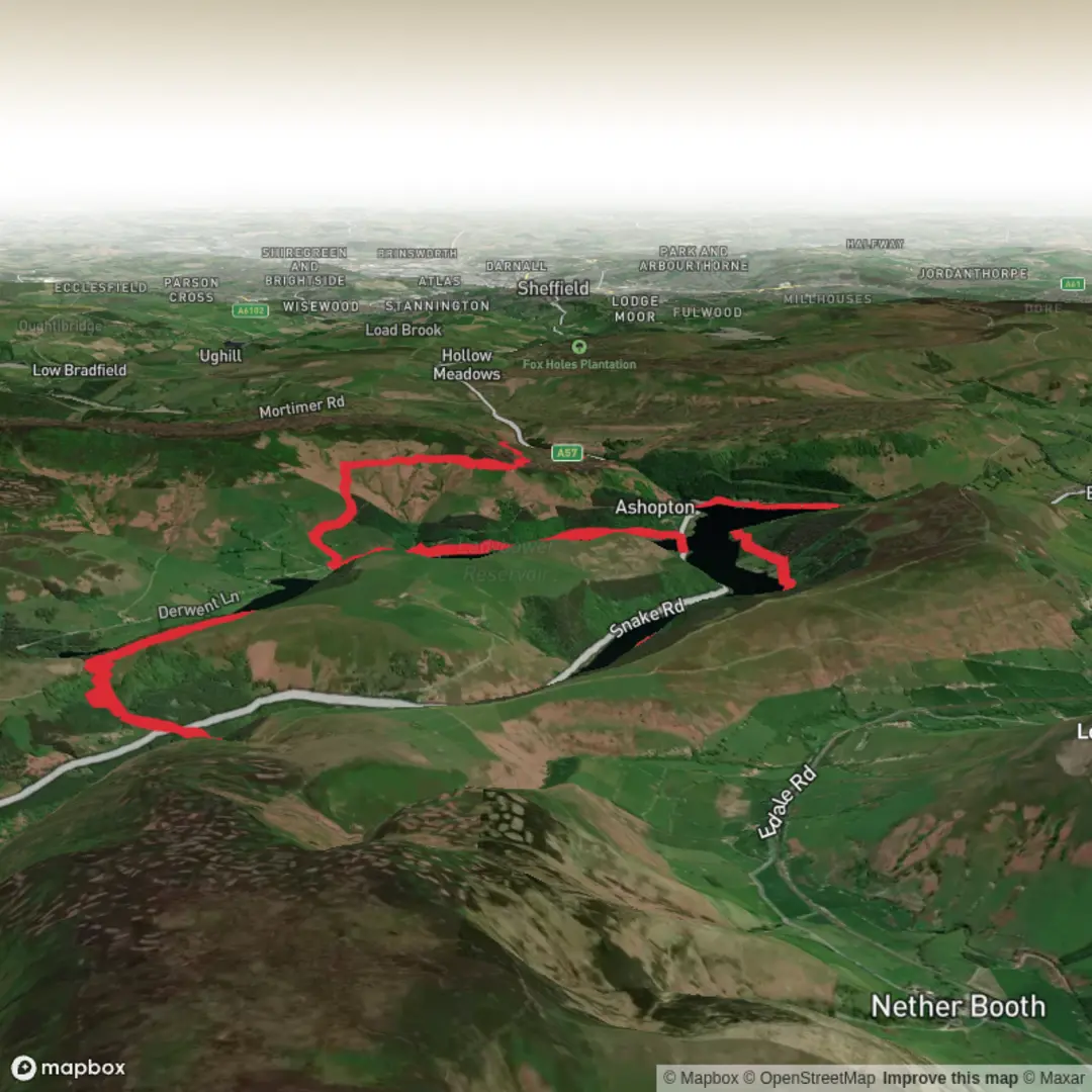
Starting from the vicinity of the Fairholmes Visitor Centre, just north of Ladybower Reservoir in the Peak District, this 21 km (13 miles) loop with approximately 600 metres (1,970 feet) of elevation gain offers a classic exploration of the Dark Peak’s gritstone edges, ancient woodland, and iconic reservoirs. The route is well-served by public transport, with regular buses from Sheffield and Bamford stopping at the visitor centre, and ample parking available for those arriving by car.Initial Ascent and Whinstone Lee TorThe trail begins with a gentle walk along the reservoir’s edge before climbing steadily through mixed woodland. Early on, you’ll pass through Grimbocar Wood, a haven for woodland birds such as nuthatches and great spotted woodpeckers. The ascent to Whinstone Lee Tor, at around 3.5 km (2.2 miles), is rewarded with sweeping views over Ladybower Reservoir and the Derwent Valley. The gritstone outcrop here is a popular spot for a short rest and photography, especially in the early morning when mist lingers over the water.Across the Moors and Down to LadybowerLeaving the tor, the path traverses open moorland, where heather and bilberry dominate the landscape. This section, between 5 km and 10 km (3–6 miles), is exposed and can be windswept, so windproof clothing is advisable. Red grouse and mountain hares are sometimes spotted darting through the heather. The route then descends gradually towards the reservoir, offering glimpses of the iconic Ashopton Viaduct and the submerged village of Derwent, whose church spire occasionally emerges during droughts—a poignant reminder of the area’s history.Woodland Trails and Reservoir ViewsThe loop continues along the reservoir’s western shore, weaving through ancient oak and birch woodland. Bluebells carpet the forest floor in spring, and deer are sometimes seen at dawn or dusk. At around 15 km (9.3 miles), the trail skirts the water’s edge, providing tranquil views and opportunities to spot waterfowl such as tufted ducks and great crested grebes.Historical Significance and NavigationThis region is steeped in history, from the construction of the Ladybower Reservoir in the 1940s—which required the flooding of villages—to its use as a training ground for the RAF’s Dambusters during World War II. Remnants of old packhorse routes and stone guide posts can still be found along the higher sections of the trail.Navigation is straightforward on well-marked paths, but weather can change rapidly on the moors. For reliable navigation, use HiiKER’s detailed maps and offline GPS tracking, especially in fog or low visibility.Final Stretch and ReturnThe final section follows the reservoir’s eastern shore, passing through more woodland and open pasture before returning to the Fairholmes Visitor Centre. Facilities here include toilets, a café, and information boards detailing local wildlife and history. The entire loop is best tackled with sturdy boots, layered clothing, and sufficient water, as refreshment points are limited outside the visitor centre.This hike offers a blend of dramatic landscapes, rich wildlife, and fascinating history, making it a rewarding day out in the heart of the Peak District.

Surfaces
Unknown
Gravel
Unpaved
Dirt
Asphalt
Grass
Concrete
Cobblestone
Wood
Comments and Reviews
User comments, reviews and discussions about the Whinstone Lee Tor, Grimbocar Wood and Ladybower Reservoir Loop, England.
average rating out of 5
0 rating(s)