Download
Preview
Add to list
More
41.4 km
~2 day
1850 m
Loop
“Experience breathtaking vistas and diverse natural wonders on this challenging, historic hike in California's rugged beauty.”
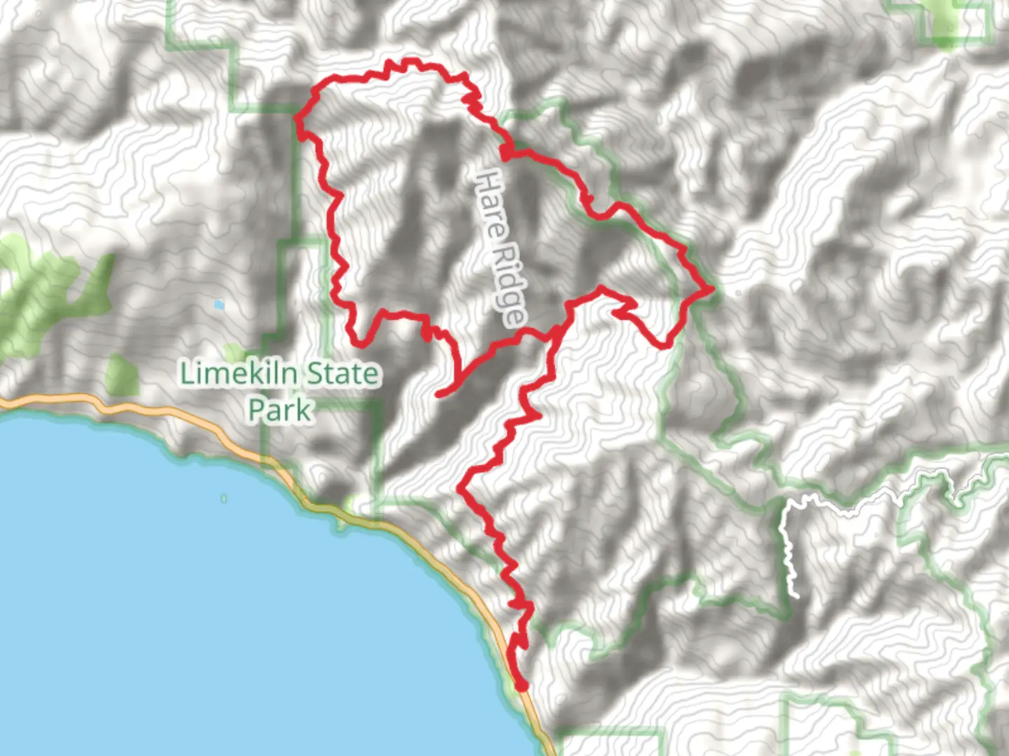
Nestled in the rugged beauty of the Santa Lucia Mountains, the Cone Peak via Stone Ridge Trail and Gamboa Trail offers an exhilarating adventure for seasoned hikers. This challenging loop spans approximately 41 kilometers (about 25.5 miles) with an elevation gain of around 1,800 meters (approximately 5,905 feet), promising breathtaking vistas and a diverse array of natural wonders.### Getting ThereThe trailhead is conveniently located near Monterey County, California. For those traveling by car, you can reach the starting point by taking Highway 1 to Nacimiento-Fergusson Road. Follow this road eastward until you reach the Cone Peak Road turnoff. Public transport options are limited in this remote area, so driving is recommended. Ensure your vehicle is suitable for rugged terrain, as the roads can be challenging.### Trail OverviewThe journey begins with the Stone Ridge Trail, which immediately immerses you in the dense, aromatic forests of the Ventana Wilderness. As you ascend, the trail offers panoramic views of the Pacific Ocean, a stunning backdrop that accompanies you for much of the hike. The initial section is steep, gaining significant elevation quickly, so be prepared for a strenuous start.### Flora and FaunaThe trail is a haven for nature enthusiasts. You'll encounter a rich tapestry of flora, including towering redwoods, chaparral, and coastal sage scrub. Keep an eye out for the vibrant wildflowers that dot the landscape, particularly in spring. Wildlife is abundant, with sightings of black-tailed deer, bobcats, and a variety of bird species, including the majestic California condor, which occasionally soars overhead.### Significant LandmarksAs you progress, the trail leads you to the Gamboa Trail junction. This section is less traveled, offering a sense of solitude and tranquility. Approximately halfway through the loop, you'll reach the summit of Cone Peak, standing at 1,571 meters (5,157 feet). This is the highest coastal mountain in the contiguous United States, providing unparalleled views of the Big Sur coastline and the vast Pacific Ocean.### Historical SignificanceThe region is steeped in history, with the Cone Peak area once serving as a lookout point for early settlers and explorers. The indigenous Esselen people also inhabited these lands, and their influence is still felt in the area's cultural heritage. As you hike, consider the footsteps of those who traversed these trails long before modern adventurers.### Navigation and SafetyGiven the trail's difficulty, it's crucial to be well-prepared. Use HiiKER for accurate navigation and trail conditions. The loop's remote nature means cell service is unreliable, so download maps and ensure you have a reliable GPS device. Weather can change rapidly, so pack layers and be prepared for varying conditions. Carry sufficient water and food, as there are no facilities along the trail.Embarking on the Cone Peak via Stone Ridge Trail and Gamboa Trail is a rewarding endeavor for those seeking a challenging hike amidst some of California's most stunning natural landscapes.

What to expect?
Activity types
Comments and Reviews
User comments, reviews and discussions about the Cone Peak via Stone Ridge Trail and Gamboa Trail, California.
average rating out of 5
0 rating(s)