Download
Preview
Add to list
More
90.2 km
~8 days
9835 m
Multi-Day
“Embark on the Zillertal Rucksack Route for an 84-kilometer alpine adventure through Austria's stunning landscapes.”
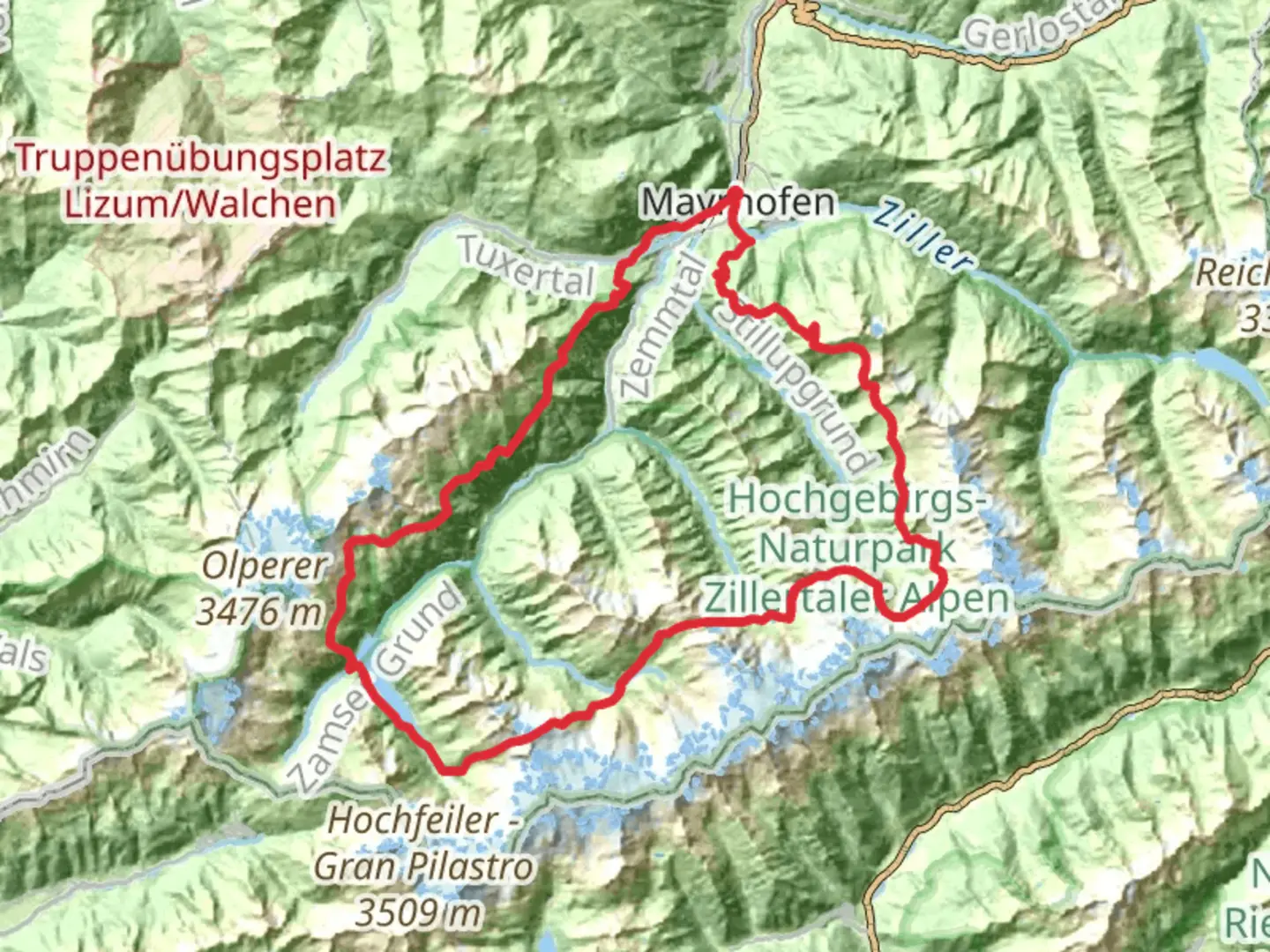
Starting near Bezirk Schwaz in Austria, the Zillertal Rucksack Route is a captivating loop trail that spans approximately 84 kilometers (52 miles) with an elevation gain of around 9000 meters (29,528 feet). This trail offers a medium difficulty rating, making it suitable for hikers with a moderate level of experience and fitness.
Getting There To reach the trailhead, you can either drive or use public transportation. If you're driving, head towards Bezirk Schwaz, where parking is available near the starting point. For those relying on public transport, take a train to Jenbach, which is the nearest major railway station. From Jenbach, you can catch a local bus to Mayrhofen, a town close to the trailhead.
Trail Overview The Zillertal Rucksack Route is a loop trail, meaning you'll start and finish at the same point. The trail takes you through the stunning Zillertal Alps, offering breathtaking views of alpine meadows, rugged peaks, and serene valleys. The route is well-marked, but it's advisable to use navigation tools like HiiKER to ensure you stay on track.
Key Sections and Landmarks
#### Mayrhofen to Kasseler Hütte Starting from Mayrhofen, the first leg of the journey takes you to Kasseler Hütte. This section is approximately 12 kilometers (7.5 miles) with an elevation gain of about 1200 meters (3937 feet). The trail winds through lush forests and past cascading waterfalls, offering a picturesque start to your hike.
#### Kasseler Hütte to Greizer Hütte From Kasseler Hütte, the next segment leads to Greizer Hütte, covering around 10 kilometers (6.2 miles) with an elevation gain of 1000 meters (3281 feet). This part of the trail is more challenging, featuring steep ascents and rocky terrain. Keep an eye out for marmots and chamois, which are commonly spotted in this area.
#### Greizer Hütte to Berliner Hütte The journey from Greizer Hütte to Berliner Hütte is one of the most scenic sections, spanning 14 kilometers (8.7 miles) with an elevation gain of 1100 meters (3609 feet). You'll traverse high alpine meadows and cross several mountain streams. Berliner Hütte itself is a historical landmark, built in 1879, and offers a glimpse into the region's mountaineering history.
#### Berliner Hütte to Furtschaglhaus Continuing from Berliner Hütte, the trail to Furtschaglhaus is about 13 kilometers (8 miles) with an elevation gain of 900 meters (2953 feet). This section offers panoramic views of glaciers and snow-capped peaks. The Furtschaglhaus is a great place to rest and refuel, with its cozy atmosphere and hearty meals.
#### Furtschaglhaus to Olpererhütte The next leg from Furtschaglhaus to Olpererhütte covers 11 kilometers (6.8 miles) with an elevation gain of 800 meters (2625 feet). This part of the trail is known for its stunning vistas of the Schlegeis Reservoir and the surrounding mountains. Olpererhütte is perched at a high altitude, offering spectacular sunset views.
#### Olpererhütte to Edelhütte From Olpererhütte, the trail descends towards Edelhütte, spanning 12 kilometers (7.5 miles) with an elevation gain of 700 meters (2297 feet). This section is relatively easier, with gentle slopes and well-maintained paths. Edelhütte is a popular spot for hikers to relax and enjoy the alpine scenery.
#### Edelhütte to Mayrhofen The final stretch from Edelhütte back to Mayrhofen is approximately 12 kilometers (7.5 miles) with an elevation gain of 300 meters (984 feet). This part of the trail takes you through dense forests and along the Ziller River, providing a serene end to your hike.
Nature and Wildlife The Zillertal Rucksack Route is home to a diverse range of flora and fauna. Alpine flowers such as edelweiss and gentian bloom in the meadows, while the forests are rich with pine and spruce trees. Wildlife enthusiasts can spot marmots, chamois, and even golden eagles soaring above the peaks.
Historical Significance The Zillertal region has a rich history, with many of the huts along the route dating back to the late 19th and early 20th centuries. These huts were originally built to support mountaineers and have since become integral parts of the hiking culture in the Alps. The Berliner Hütte, in particular, is a testament to the region's mountaineering heritage and is a must-visit for history buffs.
Preparation and Safety Given the trail's elevation gain and varying terrain, it's crucial to be well-prepared. Ensure you have sturdy hiking boots, weather-appropriate clothing, and sufficient food and water. Always check the weather forecast before setting out and consider using HiiKER for real-time navigation and trail updates.

Comments and Reviews
User comments, reviews and discussions about the Zillertal Rucksack Route, Austria.
average rating out of 5
0 rating(s)