Download
Preview
Add to list
More
2.6 km
~36 min
55 m
Out and Back
“Explore forest, wetland, and coastal views on the accessible 3-kilometer Point Whitehorn Marine Reserve Trail.”
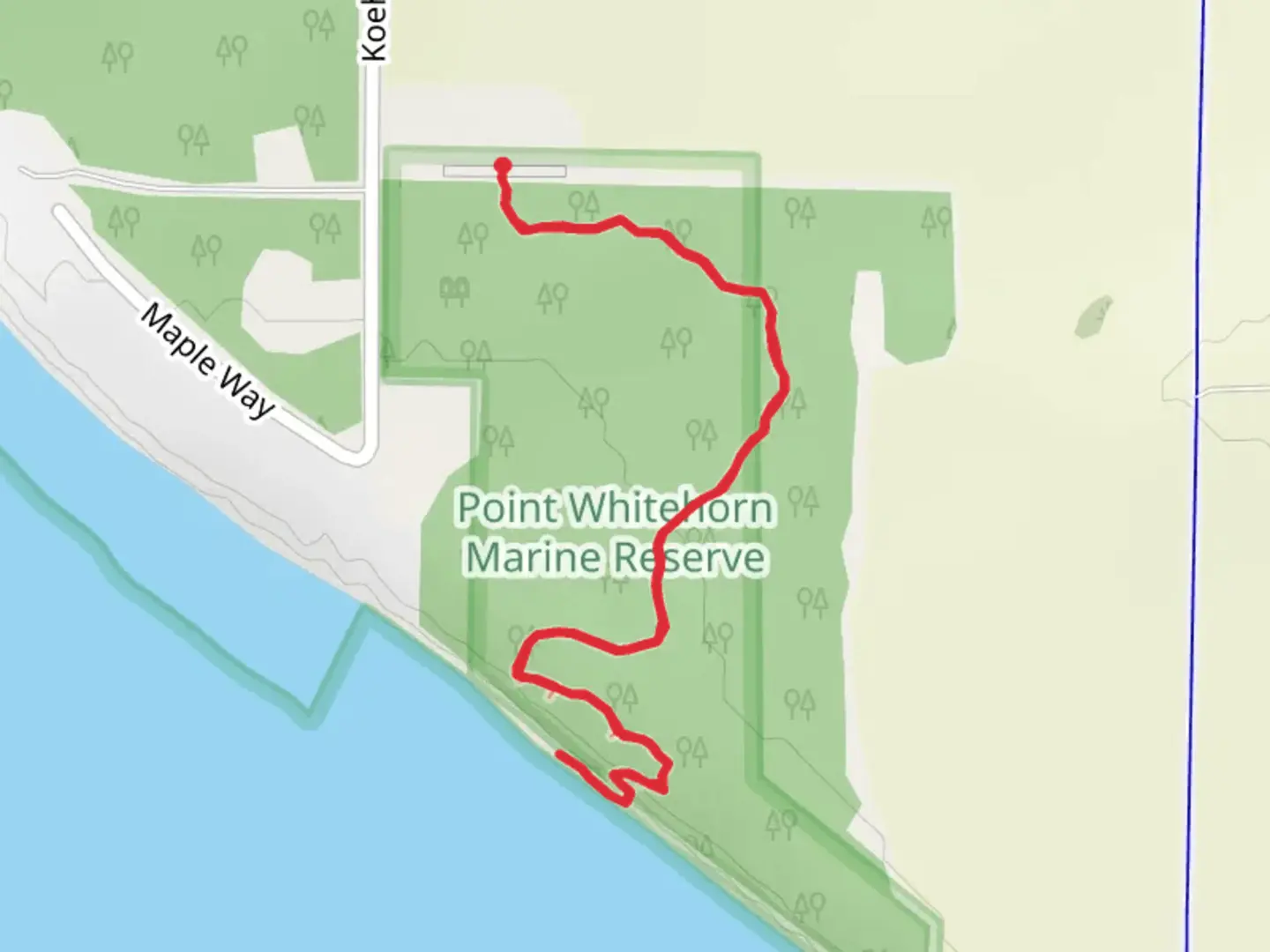
Nestled near Whatcom County, Washington, the Point Whitehorn Marine Reserve Trail is a delightful out-and-back trail stretching approximately 3 kilometers (about 1.9 miles) with virtually no elevation gain, making it accessible for a wide range of hikers. The trailhead is conveniently located near the intersection of Koehn Road and Birch Bay Drive, providing easy access whether you're arriving by car or public transport.### Getting There For those driving, take I-5 to exit 266 for Grandview Road. Head west on Grandview Road for about 13 kilometers (8 miles) until you reach Koehn Road. Turn right onto Koehn Road and continue for approximately 1.6 kilometers (1 mile) until you reach Birch Bay Drive. The trailhead is well-marked and offers ample parking.If you prefer public transport, the Whatcom Transportation Authority (WTA) provides bus services that can get you close to the trailhead. Take the Route 75 bus towards Birch Bay and disembark at the Birch Bay Drive and Koehn Road stop. From there, it's a short walk to the trailhead.### Trail Overview The Point Whitehorn Marine Reserve Trail is a relatively easy hike, but its medium difficulty rating comes from the need for careful navigation through some uneven terrain and potentially muddy sections, especially after rain. The trail is well-maintained and clearly marked, making it easy to follow. For navigation, using HiiKER can provide real-time updates and ensure you stay on track.### Flora and Fauna As you embark on this trail, you'll be greeted by a lush canopy of mixed coniferous and deciduous trees. The forest floor is carpeted with ferns, mosses, and wildflowers, particularly vibrant in the spring and early summer. Keep an eye out for native wildlife such as black-tailed deer, raccoons, and a variety of bird species including bald eagles and great blue herons.### Significant Landmarks Approximately 1 kilometer (0.6 miles) into the hike, you'll come across a wooden boardwalk that leads you through a serene wetland area. This section is particularly rich in birdlife, so bring your binoculars if you're a birdwatching enthusiast.At around the 1.5-kilometer (0.9-mile) mark, the trail opens up to a stunning viewpoint overlooking the Strait of Georgia. On clear days, you can see the San Juan Islands and even the distant peaks of the Canadian Coast Mountains. This is a perfect spot to take a break, enjoy a snack, and soak in the panoramic views.### Historical Significance The Point Whitehorn Marine Reserve is not just a natural gem but also a site of historical importance. The area was traditionally used by the Coast Salish peoples for fishing and gathering shellfish. Interpretive signs along the trail provide insights into the cultural history and ecological significance of the region.### Final Stretch The trail continues for another 0.5 kilometers (0.3 miles) past the viewpoint, leading you through a coastal forest before reaching the beach. The beach area is a great place to explore tide pools and observe marine life. Remember to check tide schedules using HiiKER to ensure safe exploration.### Tips for Hikers - Wear sturdy hiking boots, especially if you plan to visit after a rain. - Bring water and snacks, as there are no facilities along the trail. - Pack out all trash to keep the reserve pristine. - Dogs are allowed but must be kept on a leash.This trail offers a perfect blend of forest, wetland, and coastal environments, making it a rewarding hike for nature lovers and history buffs alike.

What to expect?
Activity types
Comments and Reviews
User comments, reviews and discussions about the Point Whitehorn Marine Reserve Trail, Washington.
4.38
average rating out of 5
8 rating(s)