Download
Preview
Add to list
More
18.2 km
~1 day 0 hrs
1019 m
Loop
“Explore lush forests, wildflower meadows, and historical mines on this moderate 18 km loop in Washington.”
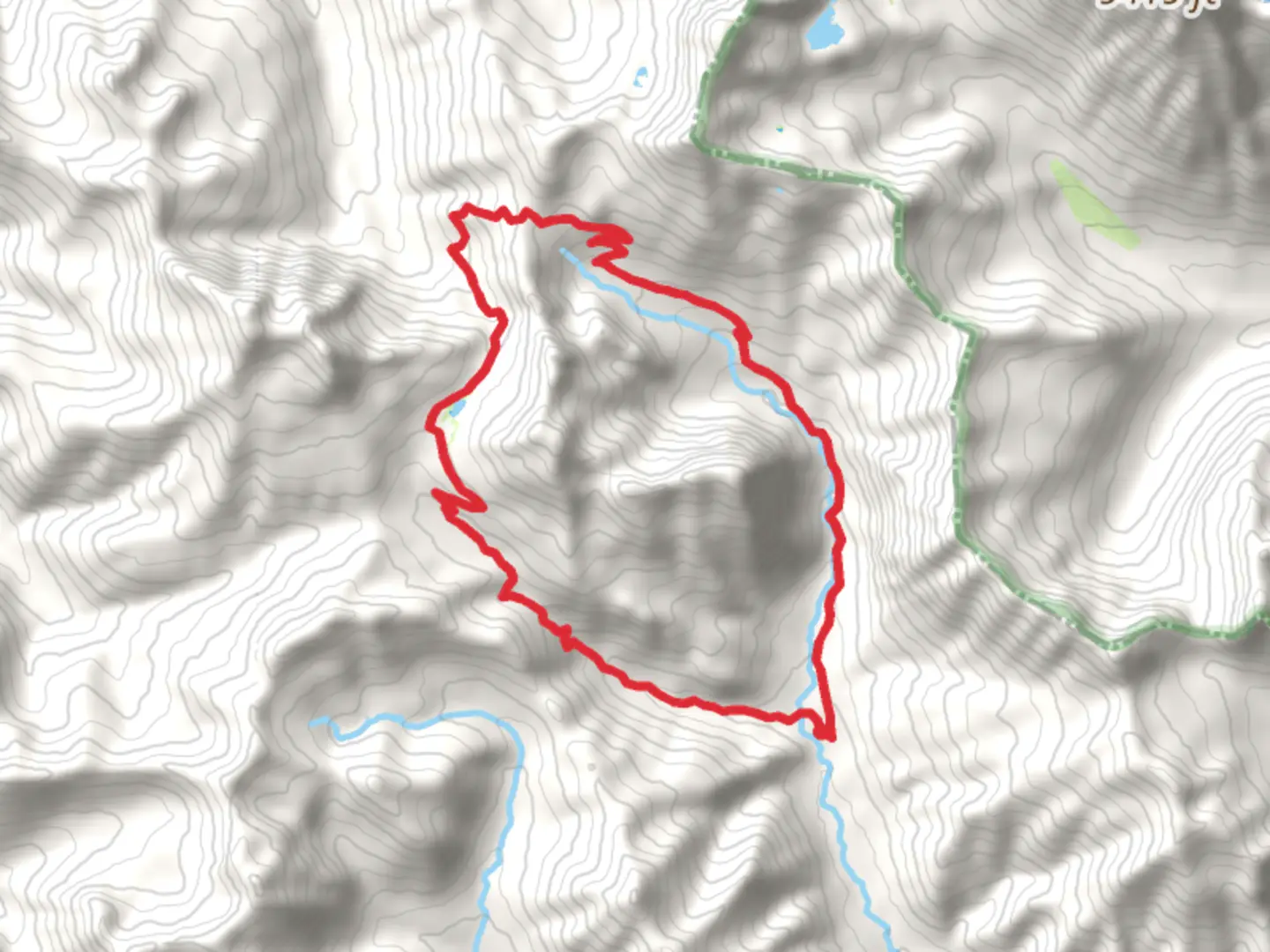
Starting your adventure near Kittitas County, Washington, the Esmeralda Basin and De Roux Loop Trail offers a captivating 18 km (11.2 miles) journey with an elevation gain of approximately 1000 meters (3280 feet). This loop trail is rated as medium difficulty, making it suitable for moderately experienced hikers.### Getting There To reach the trailhead, you can drive or use public transport. If driving, head towards the town of Cle Elum, Washington. From there, take the Teanaway Road and follow it until you reach the Esmeralda Basin Trailhead. For those relying on public transport, the nearest major bus station is in Cle Elum, from where you can arrange a taxi or rideshare to the trailhead.### Trail Overview The trail begins at the Esmeralda Basin Trailhead, located near the North Fork Teanaway River. As you start your hike, you'll be greeted by lush forests and the soothing sounds of the river. The initial section of the trail is relatively gentle, allowing you to ease into the hike.### Significant Landmarks and Nature Around 3 km (1.9 miles) into the hike, you'll encounter the first significant landmark, the Esmeralda Basin. This area is known for its stunning wildflower displays in the spring and early summer. Keep an eye out for lupines, Indian paintbrush, and other vibrant blooms.Continuing on, the trail begins to ascend more steeply as you approach the De Roux Creek. At approximately 6 km (3.7 miles), you'll cross the creek via a sturdy wooden bridge. This is a great spot to take a break and enjoy the serene surroundings.### Wildlife and Scenic Views As you gain elevation, the forest gives way to more open terrain, offering panoramic views of the surrounding peaks. The area is home to a variety of wildlife, including deer, marmots, and occasionally black bears. Always practice safe wildlife viewing by keeping a respectful distance and storing food properly.### Historical Significance The region has a rich history, with remnants of old mining operations visible along the trail. These mines date back to the late 19th and early 20th centuries when prospectors flocked to the area in search of gold and other minerals. The De Roux Mine, located near the halfway point of the loop, is one such historical site. While the mine itself is not accessible, the surrounding area offers a glimpse into the past.### Navigation and Safety Navigating the Esmeralda Basin and De Roux Loop Trail is straightforward, but it's always wise to carry a reliable navigation tool. HiiKER is an excellent app for this purpose, providing detailed maps and real-time tracking to ensure you stay on course.### Final Stretch The final section of the trail descends back into the forest, leading you towards the trailhead. This part of the hike is less strenuous, allowing you to reflect on the diverse landscapes and historical sites you've encountered.### Preparation Tips Given the elevation gain and varying terrain, it's essential to wear sturdy hiking boots and bring plenty of water. Weather conditions can change rapidly, so pack layers and be prepared for both sun and rain. Trekking poles can also be helpful, especially during the steeper sections of the trail.By planning accordingly and respecting the natural and historical significance of the area, you'll have a rewarding and memorable hiking experience on the Esmeralda Basin and De Roux Loop Trail.

What to expect?
Activity types
Comments and Reviews
User comments, reviews and discussions about the Esmeralda Basin and De Roux Loop Trail, Washington.
4.67
average rating out of 5
9 rating(s)