Download
Preview
Add to list
More
5.0 km
~1 hrs 21 min
218 m
Loop
“Explore lush forests, historical remnants, and vibrant wildlife on the moderate Primrose and Coal Creek Loop Trail.”
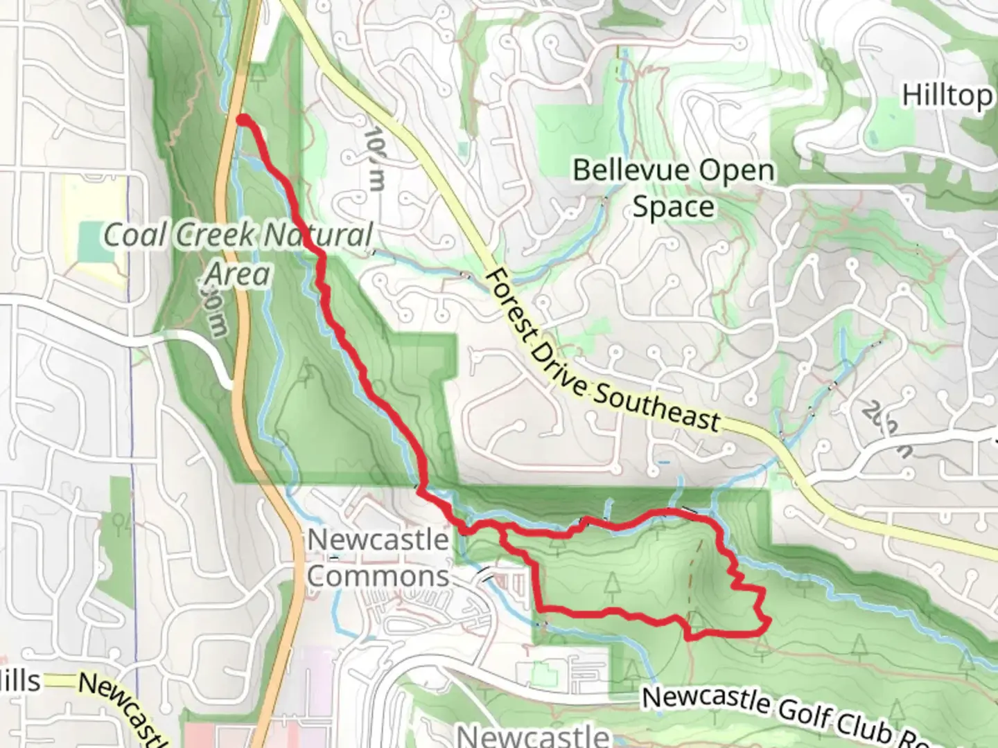
Starting your adventure near King County, Washington, the Primrose Trail and Coal Creek Loop Trail offers a delightful 5 km (approximately 3.1 miles) journey with an elevation gain of around 200 meters (656 feet). This loop trail is rated medium in difficulty, making it suitable for moderately experienced hikers.### Getting There To reach the trailhead, you can drive or use public transport. If driving, head towards the Coal Creek Parkway SE, Bellevue, WA 98006. There is a parking area near the Red Town Trailhead, which serves as a convenient starting point. For those using public transport, King County Metro Transit offers bus services that stop near the Coal Creek Parkway SE. From there, it's a short walk to the trailhead.### Trail Navigation For navigation, it's highly recommended to use the HiiKER app, which provides detailed maps and real-time updates to ensure you stay on track throughout your hike.### Trail Highlights As you embark on the trail, you'll first encounter lush forested areas filled with towering Douglas firs and western red cedars. The initial part of the trail is relatively flat, allowing you to ease into the hike while enjoying the serene surroundings.### Historical Significance About 1 km (0.6 miles) into the hike, you'll come across remnants of the region's coal mining history. The Coal Creek area was once a bustling mining community in the late 19th and early 20th centuries. Look out for old mining equipment and interpretive signs that provide insights into the area's past.### Nature and Wildlife Continuing along the trail, you'll traverse through diverse ecosystems. The forest floor is carpeted with ferns and mosses, and you might spot wildlife such as black-tailed deer, raccoons, and various bird species. Keep an eye out for the vibrant red-breasted nuthatch and the elusive pileated woodpecker.### Elevation Gain As you approach the 2.5 km (1.55 miles) mark, the trail begins to ascend more steeply. This section offers a moderate challenge with an elevation gain of about 100 meters (328 feet) over a short distance. The effort is rewarded with stunning views of the surrounding landscape, especially during the fall when the foliage turns into a spectacular array of colors.### Key Landmarks Around the 3.5 km (2.17 miles) point, you'll reach the Primrose Overlook. This spot provides a panoramic view of the Coal Creek Valley and is an excellent place to take a break and soak in the scenery. From here, the trail descends gradually, leading you back through dense forest and alongside Coal Creek itself.### Final Stretch The last kilometer (0.62 miles) of the trail is relatively flat and follows the creek closely. The soothing sounds of flowing water accompany you as you make your way back to the trailhead. This section is particularly beautiful in spring when wildflowers bloom along the creek banks.### Preparation Tips Given the moderate difficulty of the trail, it's advisable to wear sturdy hiking boots and bring plenty of water. The trail can be muddy in sections, especially after rain, so be prepared for potentially slippery conditions. Always check the weather forecast before heading out and consider bringing a light rain jacket if there's a chance of showers.By following these guidelines and using the HiiKER app for navigation, you'll be well-prepared to enjoy the natural beauty and historical richness of the Primrose Trail and Coal Creek Loop Trail.

What to expect?
Activity types
Comments and Reviews
User comments, reviews and discussions about the Primrose Trail and Coal Creek Loop Trail, Washington.
4.67
average rating out of 5
18 rating(s)