Download
Preview
Add to list
More
7.8 km
~3 hrs 34 min
1216 m
Out and Back
“Challenge yourself on the rewarding Mailbox Peak Trail with stunning views, diverse wildlife, and iconic summit.”
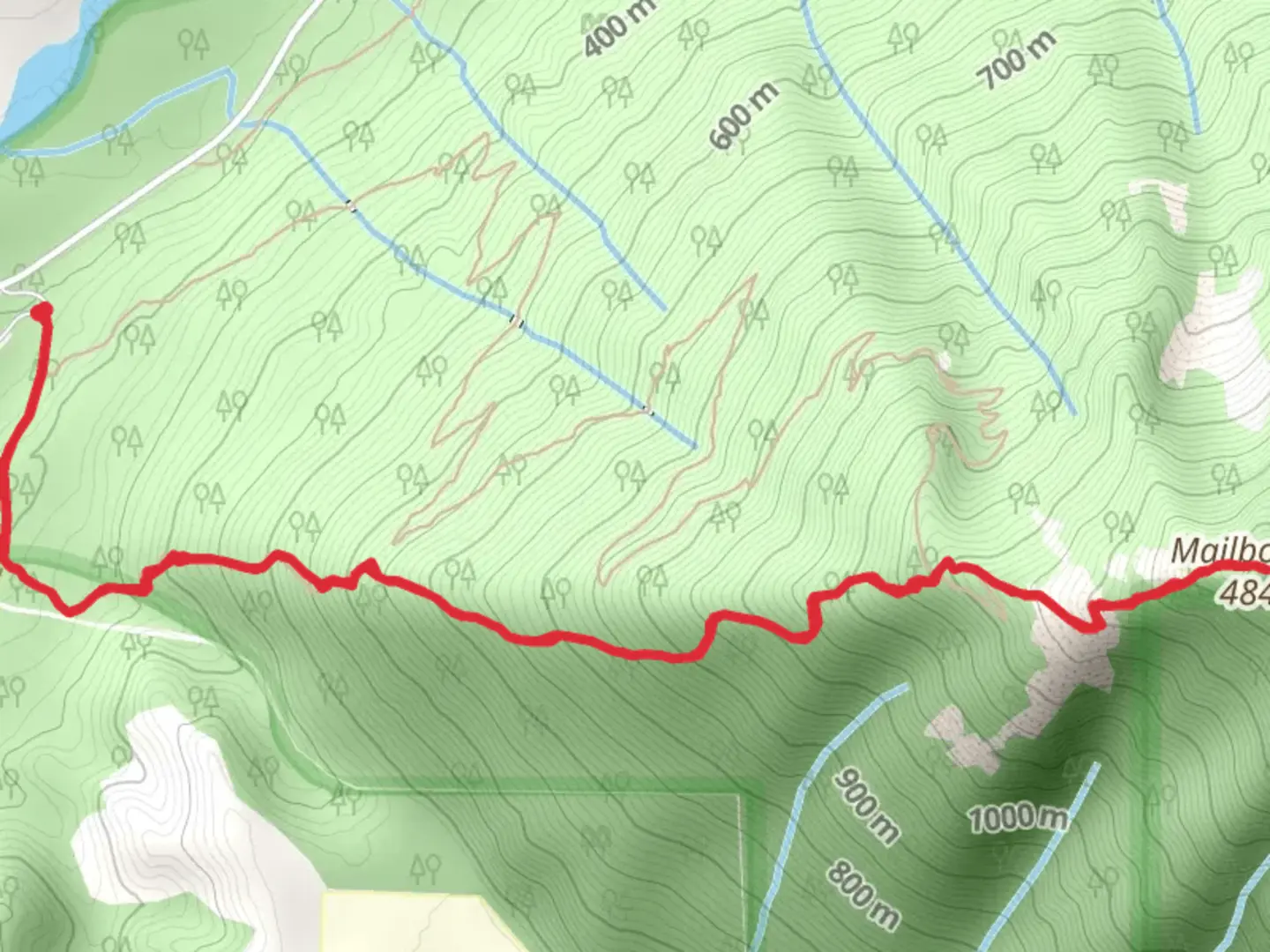
Starting your adventure near King County, Washington, the Mailbox Peak Trail Out and Back is a challenging yet rewarding hike. The trail spans approximately 8 kilometers (around 5 miles) with a significant elevation gain of about 1,200 meters (approximately 4,000 feet). This trail is classified as medium difficulty, making it suitable for hikers with some experience and a good level of fitness.### Getting There To reach the trailhead, you can drive or use public transportation. If driving, head towards the Middle Fork Snoqualmie River Road, near North Bend, Washington. The nearest known address is the Middle Fork Trailhead, which is a good landmark to set your GPS to. For those using public transport, you can take a bus to North Bend and then a taxi or rideshare service to the trailhead.### Trail Overview The trail begins with a relatively gentle ascent through dense forest, offering a serene start to your hike. As you progress, the trail becomes steeper and more rugged. The first 2 kilometers (about 1.2 miles) are a mix of switchbacks and rocky terrain, gaining approximately 300 meters (around 1,000 feet) in elevation.### Significant Landmarks and Nature At around the 3-kilometer (1.9-mile) mark, you'll encounter a clearing known as the "Boulder Field." This area is a significant landmark where the trail becomes more challenging. The boulder field is a great spot to take a short break and enjoy the panoramic views of the surrounding mountains.Continuing past the boulder field, the trail becomes steeper and more strenuous. The next 2 kilometers (1.2 miles) will see you gaining another 600 meters (approximately 2,000 feet) in elevation. This section is characterized by rocky outcrops and narrow paths, so caution is advised.### Wildlife and Flora The Mailbox Peak Trail is home to a variety of wildlife, including black bears, deer, and numerous bird species. Keep an eye out for the distinctive Douglas fir and western hemlock trees that dominate the landscape. During spring and summer, the trail is adorned with wildflowers, adding a splash of color to your hike.### Historical Significance The trail gets its name from the mailbox that was placed at the summit in the 1960s by a group of hikers. This mailbox has become an iconic symbol and a popular photo spot for those who reach the peak. The tradition continues today, with hikers often leaving notes or small items in the mailbox.### Final Ascent and Summit The final push to the summit is the most challenging part of the hike. The last kilometer (0.6 miles) involves a steep climb with an elevation gain of about 300 meters (1,000 feet). The trail here is rocky and can be slippery, especially after rain, so proper footwear and trekking poles are recommended.Upon reaching the summit, you'll be rewarded with breathtaking views of the Cascade Range, Mount Rainier, and the Snoqualmie Valley. The iconic mailbox at the peak is a testament to your hard work and determination.### Navigation For navigation, it's highly recommended to use the HiiKER app, which provides detailed maps and real-time updates to ensure you stay on the right path.### Descent The descent follows the same path back to the trailhead. While descending, take your time and watch your footing, especially in the steeper sections. The total round trip will take you back through the same beautiful landscapes, offering a different perspective on your way down.Prepare well, stay safe, and enjoy the Mailbox Peak Trail Out and Back.

What to expect?
Activity types
Comments and Reviews
User comments, reviews and discussions about the Mailbox Peak Trail Out and Back, Washington.
4.75
average rating out of 5
12 rating(s)