Download
Preview
Add to list
More
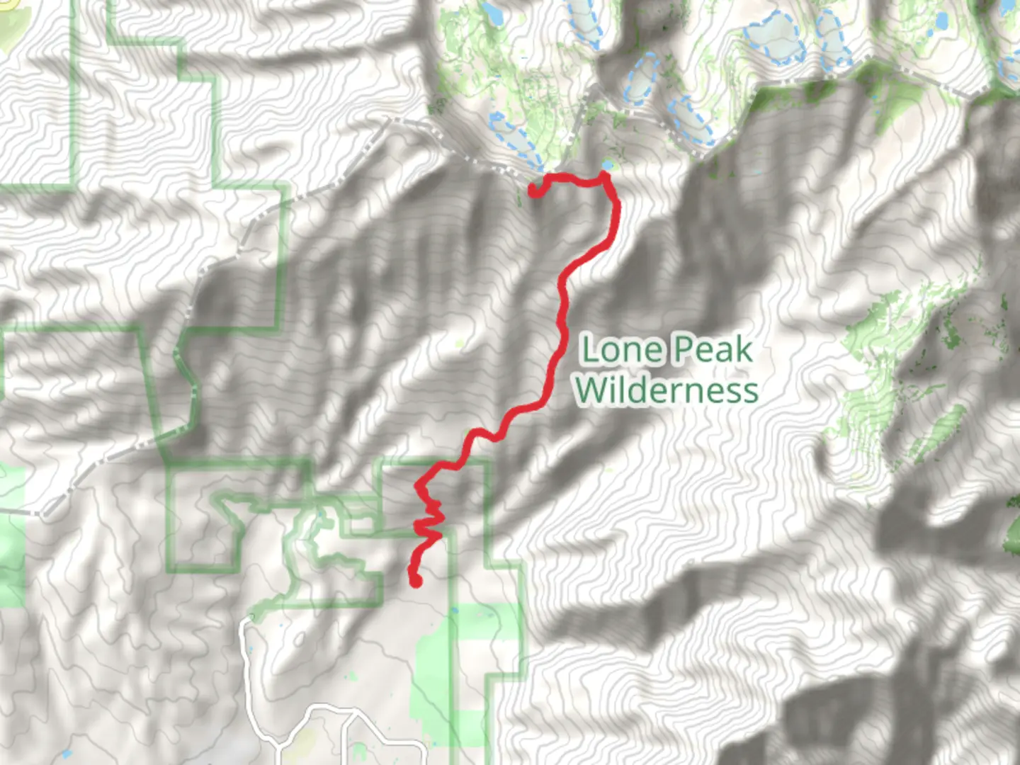
17.6 km
~6 hrs 28 min
1770 m
Out and Back
“Embark on a challenging, scenic hike from Dry Creek Canyon to Big Horn Peak with stunning alpine vistas.”
Starting your adventure near Utah County, Utah, the Lake Hardy Trail and Big Horn Peak trailhead is accessible by car, with the nearest significant landmark being the Dry Creek Trailhead. If you're using public transport, the closest major city is Salt Lake City, from where you can take a bus to Alpine and then a short taxi ride to the trailhead.
The trail spans approximately 18 km (11.2 miles) with an elevation gain of around 1700 meters (5577 feet), making it a challenging yet rewarding out-and-back hike. The trail is rated as medium difficulty, so be prepared for a strenuous climb, especially in the latter sections.
Initial Ascent and Dry Creek Canyon
The hike begins with a steady ascent through Dry Creek Canyon. The first 3 km (1.9 miles) are relatively moderate, gaining about 300 meters (984 feet) in elevation. The trail here is well-marked and shaded by a canopy of aspen and pine trees, providing a cool and refreshing start. Keep an eye out for mule deer and wild turkeys, which are commonly seen in this area.
Midway Point and Lake Hardy
As you continue, the trail becomes steeper and more rugged. Around the 6 km (3.7 miles) mark, you'll reach the halfway point, having gained approximately 800 meters (2625 feet) in elevation. Here, the trail opens up to stunning views of the surrounding Wasatch Range. The path can be rocky and uneven, so sturdy hiking boots are recommended.
At about 9 km (5.6 miles), you'll arrive at Lake Hardy, a serene alpine lake nestled in a granite basin. This is a perfect spot to take a break, enjoy a snack, and soak in the breathtaking scenery. The lake is surrounded by wildflowers in the summer months, and you might spot mountain goats grazing on the nearby slopes.
Final Push to Big Horn Peak
From Lake Hardy, the trail to Big Horn Peak becomes more challenging. The final 2 km (1.2 miles) involve a steep ascent, gaining an additional 500 meters (1640 feet) in elevation. The path is less defined here, so using a navigation tool like HiiKER is highly recommended to stay on track.
As you approach the summit of Big Horn Peak, the terrain becomes rocky and exposed. The peak offers panoramic views of the Utah Valley and the surrounding mountain ranges. On a clear day, you can see as far as the Great Salt Lake. This section of the trail is also known for its historical significance, as it was used by early settlers and Native American tribes for hunting and travel.
Descent
The return journey follows the same path back to the trailhead. While descending, take your time to enjoy the changing perspectives and the opportunity to spot wildlife you might have missed on the way up. The descent can be tough on the knees, so trekking poles can be helpful.
Preparation and Safety
Given the elevation gain and the rugged terrain, it's essential to be well-prepared. Carry plenty of water, high-energy snacks, and layers of clothing to adjust to changing weather conditions. The trail can be snow-covered in early spring and late fall, so check current trail conditions before you go. Always let someone know your hiking plans and estimated return time.
This hike offers a mix of natural beauty, challenging terrain, and historical significance, making it a memorable adventure for those who are well-prepared.

What to expect?
Activity types
Comments and Reviews
User comments, reviews and discussions about the Lake Hardy Trail and Big Horn Peak, Utah.
4.59
average rating out of 5
17 rating(s)