Download
Preview
Add to list
More
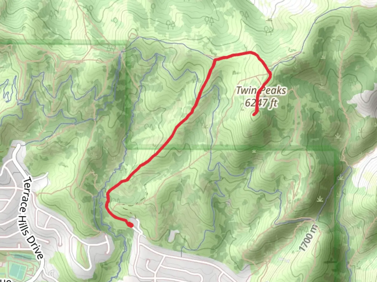
5.2 km
~1 hrs 41 min
393 m
Out and Back
“Embark on a scenic, history-laced ascent through Utah's Wasatch Range on the Twin Peaks Connect trail.”
Embarking on the Twin Peaks via Twin Peaks Connect trail, hikers will find themselves exploring the rugged beauty of the Wasatch Range near Salt Lake County, Utah. This approximately 5 km (3.1 miles) out-and-back journey offers an elevation gain of around 300 meters (984 feet), presenting a moderately challenging adventure suitable for those with some hiking experience.
Getting to the Trailhead The trailhead is conveniently located within a short drive from Salt Lake City. If you're coming by car, you can navigate to the base of Big Cottonwood Canyon, where you'll find ample parking near the entry point. For those opting for public transportation, local bus services frequently run to Big Cottonwood Canyon, dropping you off within walking distance of the trailhead.
The Hike As you set out on the Twin Peaks Connect, the path will lead you through a mix of terrains, starting with a well-defined trail that meanders through a forested area. The canopy of aspen and pine trees provides a serene backdrop, with the occasional clearing offering glimpses of the valley below. Keep an eye out for local wildlife, including mule deer and various bird species that call this habitat home.
After about 1.5 km (0.9 miles), the trail begins to ascend more steeply, and the vegetation starts to thin out, giving way to rugged alpine scenery. The path can become rocky, so sturdy footwear is recommended. As you gain elevation, the panoramic views become increasingly spectacular, with the Salt Lake Valley stretching out to the west and the higher peaks of the Wasatch Range looming to the east.
Historical Significance The Wasatch Range has a rich history, with the Twin Peaks area being no exception. The mountains have been a significant landmark for Native American tribes, early settlers, and miners in the 19th century. As you hike, consider the historical significance of these trails, which have been traversed for centuries and have played a role in the development of the region.
Reaching the Summit Approaching the summit, the trail can become less distinct, and careful navigation is key. Using HiiKER to track your progress is advisable to ensure you're on the right path. The final push to the peak is the most strenuous part of the hike, with some loose scree and steep sections. However, the effort is rewarded with breathtaking 360-degree views from the top, where on a clear day, you can see across the entire Salt Lake Valley and into the neighboring canyons.
Descent The return journey follows the same route back down to the trailhead. Take care on the descent, as the loose terrain can be tricky to navigate. The downhill trek offers a different perspective on the stunning landscape you've just traversed, with the afternoon light casting long shadows and highlighting the rugged contours of the surrounding peaks.
Preparation and Safety Before setting out, ensure you have adequate water, sun protection, and layers to adapt to changing weather conditions, which can be quite variable at higher elevations. It's also wise to check local trail conditions and weather forecasts. Always leave no trace of your visit to help preserve the natural beauty of the area for future generations.
By preparing accordingly and respecting the trail, your hike to Twin Peaks via Twin Peaks Connect will be a memorable experience, offering a blend of natural splendor, physical challenge, and historical intrigue.

What to expect?
Activity types
Comments and Reviews
User comments, reviews and discussions about the Twin Peaks via Twin Peaks Connect, Utah.
4.53
average rating out of 5
17 rating(s)