Download
Preview
Add to list
More
10.5 km
~2 hrs 39 min
329 m
Loop
“Embark on The Sentry Loop for diverse terrains, panoramic vistas, and historical petroglyphs in Davis County.”
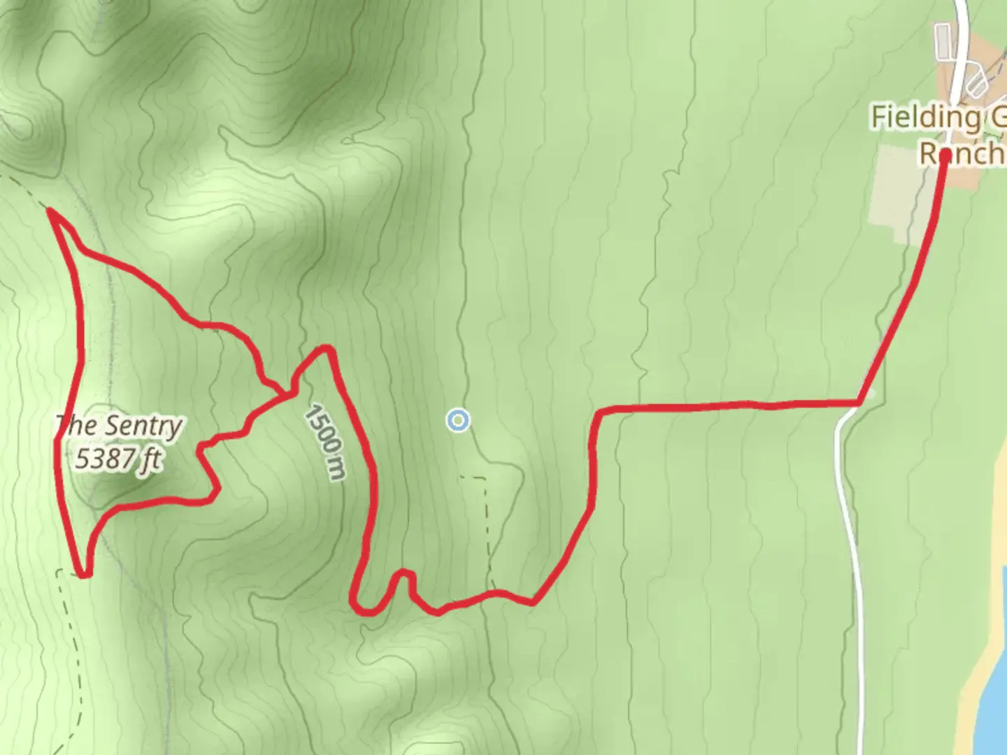
Starting your adventure near Davis County, Utah, the trailhead for The Sentry Loop is conveniently accessible by car. If you're using public transport, the nearest significant landmark is the Layton Hills Mall, from where you can catch a local bus or taxi to the trailhead. Parking is available at the trailhead, so driving is a straightforward option.Trail OverviewThe Sentry Loop spans approximately 11 kilometers (around 6.8 miles) with an elevation gain of about 300 meters (approximately 984 feet). This loop trail is rated as medium difficulty, making it suitable for moderately experienced hikers. The trail offers a mix of terrains, including forested areas, open meadows, and rocky sections, providing a diverse hiking experience.Key Landmarks and Points of InterestAs you embark on the trail, you'll first encounter a dense forest area, rich with pine and aspen trees. About 2 kilometers (1.2 miles) in, the trail opens up to a beautiful meadow, often filled with wildflowers in the spring and summer months. This is a great spot to take a break and enjoy the scenery.Continuing on, around the 5-kilometer (3.1-mile) mark, you'll reach a rocky outcrop that offers stunning panoramic views of the surrounding valleys and mountains. This is one of the highlights of the trail and a perfect place for photography enthusiasts.Wildlife and NatureThe Sentry Loop is home to a variety of wildlife. Keep an eye out for deer, foxes, and a variety of bird species. In the early morning or late afternoon, you might even spot a moose. The trail also features several small streams, which are great for a quick refreshment or to observe local aquatic life.Historical SignificanceThe region around Davis County has a rich history, with Native American tribes having inhabited the area for centuries. Along the trail, you might notice some ancient petroglyphs etched into the rocks, a testament to the area's historical significance. These petroglyphs are protected, so please admire them without touching.Navigation and SafetyFor navigation, it's highly recommended to use the HiiKER app, which provides detailed maps and real-time updates. The trail is well-marked, but having a reliable navigation tool ensures you stay on track. Be prepared for changing weather conditions, especially if you're hiking in the spring or fall. The trail can become slippery after rain, so good hiking boots with strong grip are essential. Carry enough water and snacks, as there are no facilities along the trail.Getting ThereIf you're driving, set your GPS to the nearest known address: Layton Hills Mall, Layton, UT 84041. From there, follow local roads to the trailhead. Public transport users can take a bus or taxi from the mall to the trailhead.Enjoy your hike on The Sentry Loop, and remember to respect the natural environment and historical sites along the way.

What to expect?
Activity types
Comments and Reviews
User comments, reviews and discussions about the The Sentry Loop, Utah.
4.57
average rating out of 5
14 rating(s)