Download
Preview
Add to list
More
3.7 km
~1 hrs 9 min
244 m
Out and Back
“The Frary Peak and Dooly Knob trails offer stunning views, diverse wildlife, and moderate hiking challenges.”
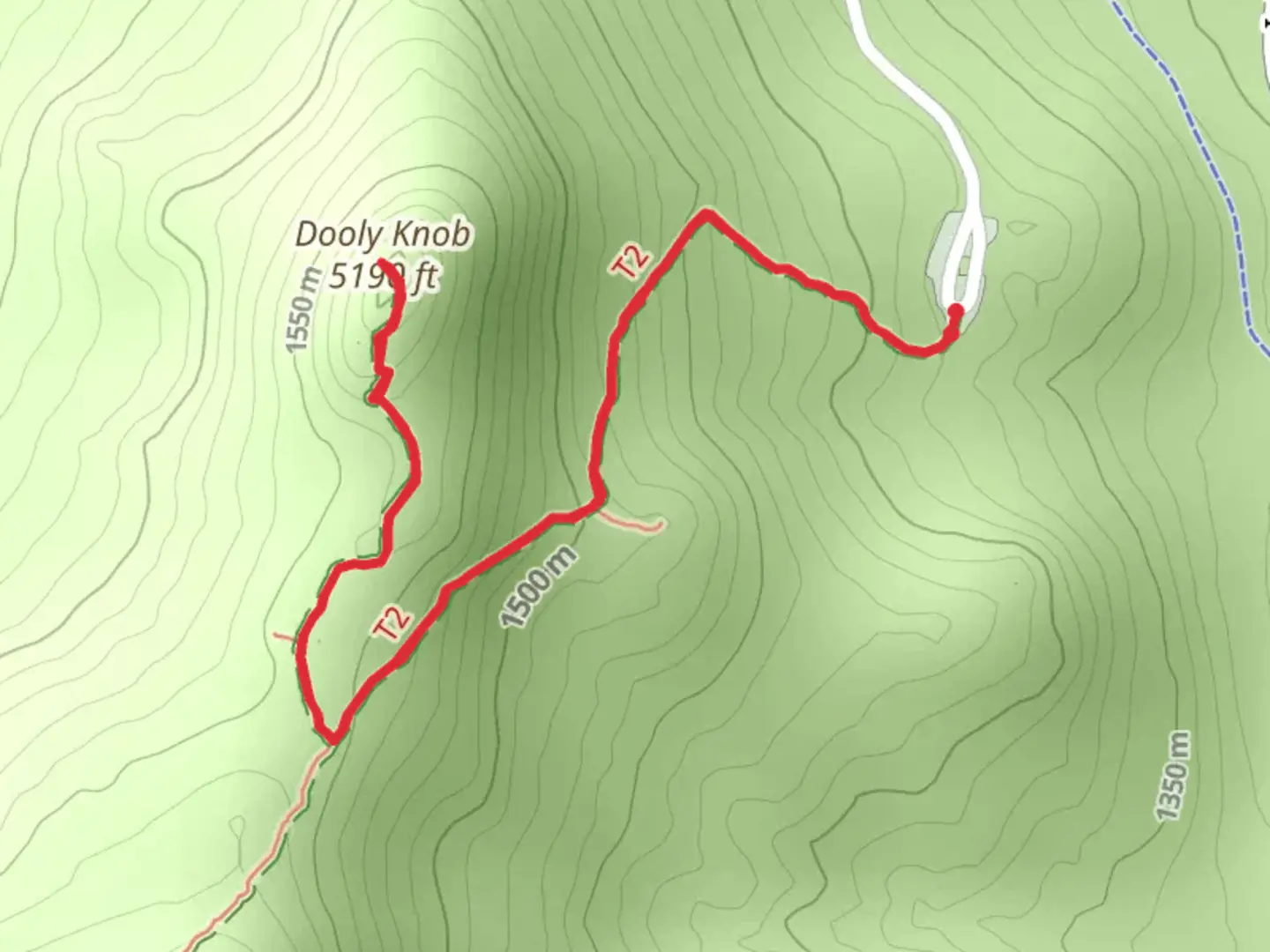
Starting near Davis County, Utah, the Frary Peak Trail and Dooly Knob Trail offer a rewarding hiking experience with a total distance of around 4 km (2.5 miles) and an elevation gain of approximately 200 meters (656 feet). This out-and-back trail is rated as medium difficulty, making it suitable for moderately experienced hikers.### Getting There To reach the trailhead, you can drive or use public transportation. If driving, head towards Antelope Island State Park, accessible via the Antelope Island Causeway from Syracuse, Utah. The nearest significant landmark is the Antelope Island Visitor Center, located at 4528 W 1700 S, Syracuse, UT 84075. From there, follow the signs to the Frary Peak Trailhead. Public transport options are limited, so driving is the most convenient way to get there.### Trail Overview The trail begins at the Frary Peak Trailhead, situated at an elevation of about 1,280 meters (4,200 feet). The initial section of the trail is relatively gentle, allowing hikers to acclimate to the terrain. As you progress, the trail becomes steeper, with switchbacks that offer stunning views of the Great Salt Lake and the surrounding landscape.### Significant Landmarks and Nature At approximately 1 km (0.6 miles) into the hike, you'll reach a viewpoint that offers panoramic vistas of the Great Salt Lake. This is an excellent spot for a short break and some photography. Continuing on, the trail becomes more rugged, with rocky outcrops and native vegetation such as sagebrush and juniper trees.### Wildlife Antelope Island is renowned for its diverse wildlife. Keep an eye out for bison, pronghorn antelope, and mule deer. Birdwatchers will also appreciate the variety of avian species, including hawks, eagles, and various shorebirds. Remember to maintain a safe distance from all wildlife.### Dooly Knob At around 2 km (1.25 miles) into the hike, you'll reach the junction for Dooly Knob. This short detour is well worth the effort, offering a 360-degree view of the island and the lake. The elevation gain to Dooly Knob is minimal, making it an easy addition to your hike.### Frary Peak Continuing past the Dooly Knob junction, the trail becomes steeper and more challenging. The final push to Frary Peak involves navigating rocky terrain and some narrow sections. Upon reaching the summit, at an elevation of approximately 2,010 meters (6,594 feet), you'll be rewarded with breathtaking views that make the effort worthwhile.### Historical Significance Antelope Island has a rich history, with evidence of human activity dating back thousands of years. The island was named after the pronghorn antelope by early explorers John C. Frémont and Kit Carson. The area also has historical significance for the indigenous peoples who once inhabited the region.### Navigation For accurate navigation, consider using the HiiKER app, which provides detailed maps and real-time updates to ensure you stay on the correct path.### Return Journey The return journey follows the same path back to the trailhead. Take your time descending, as the rocky sections can be tricky. Enjoy the changing perspectives and the opportunity to spot any wildlife you may have missed on the ascent.This hike offers a blend of natural beauty, wildlife, and historical significance, making it a must-visit for anyone exploring the Davis County area.

What to expect?
Activity types
Comments and Reviews
User comments, reviews and discussions about the Frary Peak Trail and Dooly Knob Trail, Utah.
4.6
average rating out of 5
20 rating(s)