Download
3D Flyover
Add to list
More
20.8 km
~6 hrs 32 min
1425 m
Multi-Day
“Embark on the arduous yet rewarding Arc Dome hike, traversing Nevada's history and high-altitude vistas.”
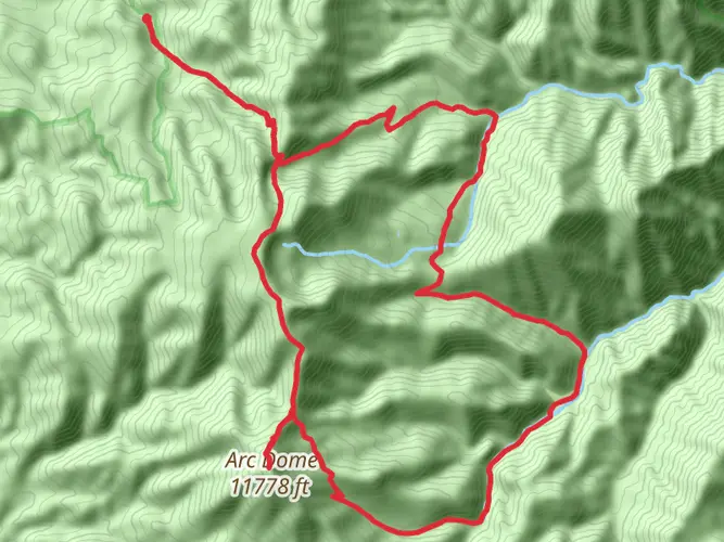
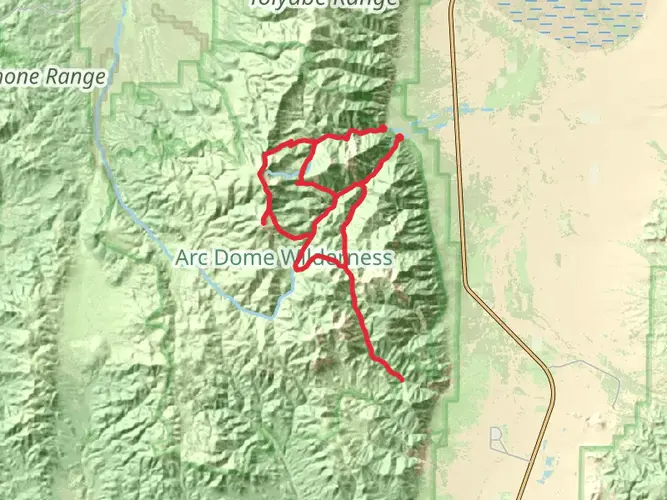
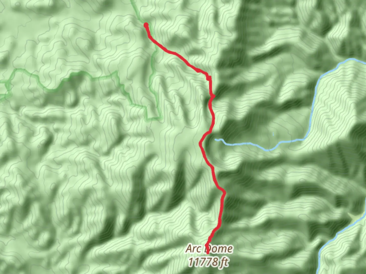
Arc Dome is a challenging and rewarding hike located near Nye County, Nevada, offering an approximate distance of 21 kilometers (13 miles) and an elevation gain of around 1400 meters (4593 feet). This loop trail is considered difficult due to its steep ascents and the high altitude at which it is situated.
Getting to the Trailhead
To reach the trailhead, hikers can drive to the small town of Carvers and then take the well-marked State Route 82 towards the Arc Dome Wilderness. The trailhead is accessible by car via a dirt road that branches off from State Route 82, leading to the Columbine Campground. This is the most common starting point for the hike. Public transportation options are limited in this remote area, so a personal vehicle is recommended.
Navigating the Trail
Hikers should prepare for a full day of trekking and are advised to start early in the morning to avoid the afternoon heat. The trail begins with a gradual incline through a high desert landscape dotted with sagebrush and pinyon pine. As you ascend, the vegetation transitions to a lush forest of aspen and mountain mahogany.
After approximately 5 kilometers (3 miles), the trail steepens as it approaches the Toiyabe Crest Trail. Here, hikers will find themselves navigating switchbacks that offer stunning views of the Reese River Valley and the surrounding Toiyabe Range. It's essential to have a reliable navigation tool like HiiKER to track your progress and ensure you stay on the correct path.
Landmarks and Natural Features
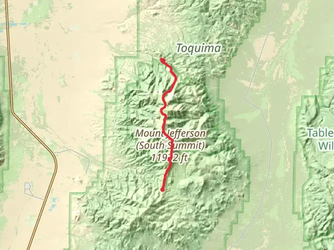
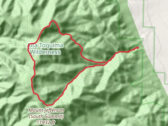
One of the most significant landmarks on the Arc Dome hike is the namesake peak itself. Arc Dome is the highest point in the Toiyabe Range, and reaching the summit provides a panoramic view that is simply breathtaking. The summit area is approximately 10.5 kilometers (6.5 miles) from the trailhead.
The trail also passes by several alpine meadows, which in the spring and early summer are awash with wildflowers, including lupines and Indian paintbrush. Wildlife sightings may include mule deer, mountain goats, and a variety of bird species, such as the mountain bluebird and the American kestrel.
Historical Significance
The region around Arc Dome is rich in history, with the Toiyabe Range having been a key location for mining activities in the 19th and early 20th centuries. Hikers may come across old mining equipment and structures that serve as a reminder of Nevada's silver and gold rush era.
Preparing for the Hike
Due to the trail's difficulty and remote location, it is crucial for hikers to be well-prepared. This includes bringing plenty of water—at least 4 liters per person—as there are limited sources along the route. Additionally, hikers should pack high-energy food, a first-aid kit, and layers of clothing to accommodate the changing temperatures at different elevations.
Safety Considerations
The trail can be challenging to follow in places, so a detailed map or GPS device with the trail loaded on HiiKER is recommended. Weather conditions can change rapidly in the mountains, so hikers should be prepared for the possibility of thunderstorms, especially in the afternoon. It's also important to be aware of the symptoms of altitude sickness and to acclimatize properly before attempting the hike.
By respecting the trail and preparing adequately, hikers can enjoy a memorable experience exploring the natural beauty and historical significance of the Arc Dome trail.

Frequently asked questions
How long does the Arc Dome hike in Nye County take to complete?
Arc Dome is about 20.82 km, or roughly 13 miles, with 1,425 m of climbing, so it is usually treated as a full-day effort or a short overnight trip. Strong hikers often finish it in a long day, but the combination of steep gain, high elevation, and remote access makes an early start important.
Where is the trailhead and parking for the Arc Dome hike?
The usual starting point for Arc Dome is the Columbine Campground area in the Arc Dome Wilderness, where the Columbine Trail climbs to the Toiyabe Crest National Recreation Trail. Columbine Campground sits around 8,600 feet and serves as the main staging area for hikers and stock users heading toward Arc Dome.
How hard is the Arc Dome hike and why is it rated extra difficult?
Arc Dome is rated Extra Difficult because the route packs 1,425 m of elevation gain into just over 20.8 km. The climb from the Columbine Campground side rises from forest into high open terrain near the Toiyabe Crest, and the altitude adds another layer of difficulty on top of the steep ascent.
What is the best time of year to hike Arc Dome in Nevada?
The most reliable season for Arc Dome is typically summer into early fall, when access roads and high trails are more likely to be open. Forest Service seasonal guidance for mountain campgrounds in this part of Nevada notes that roads often open around mid to late May or early June, depending on snow, and can close again in early October.
What landmarks and views can hikers expect on the Arc Dome hike?
Arc Dome is the highest peak in the Toiyabe Range, and the route commonly reaches it by joining the Toiyabe Crest Trail above Columbine Campground. Higher on the mountain, the trail opens to broad views across the Reese River Valley and the basin-and-range landscape, with summit views that can include Mount Jefferson, Toiyabe Dome, and the White Mountains in California on clear days.
Is the Arc Dome hike a loop or an out-and-back route?
Arc Dome is often described from Columbine Campground as an out-and-back summit hike using the Columbine Trail and the Toiyabe Crest Trail, even though longer backpacking variations exist in the surrounding wilderness. For a hike of about 20.82 km, the standard expectation is a summit route returning to the Columbine Campground trailhead.
Can you camp near the Arc Dome trailhead before hiking?
Yes. Columbine Campground is the main trailhead campground for Arc Dome and is commonly used as the night-before base for summit attempts and longer trips on the Toiyabe Crest Trail. It is a small, primitive campground along Stewart Creek, so services are limited and the setting is remote.
Comments and Reviews
User comments, reviews and discussions about the Arc Dome, Nevada.
4.53
average rating out of 5
17 rating(s)