Download
Preview
Add to list
More
40.0 km
~3 days
2339 m
Multi-Day
“Embark on an unforgettable trek through ancient forests and rugged peaks on Nevada's challenging North and South Loop Trail.”
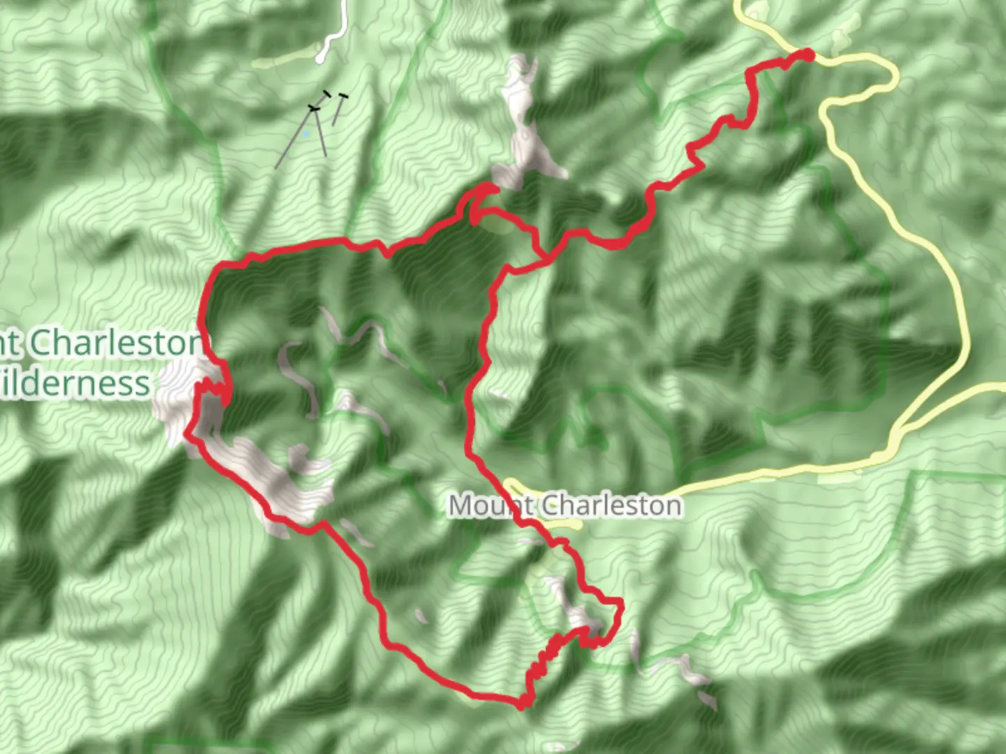
The North and South Loop Trail, spanning approximately 40 kilometers (about 25 miles) with an elevation gain of around 2300 meters (approximately 7546 feet), is a challenging yet rewarding loop trail located near Clark County, Nevada. This trail is not for the faint of heart, as it is estimated to be difficult due to its steep inclines and the length of the hike.Getting to the TrailheadTo reach the trailhead, hikers can drive to the Kyle Canyon area of the Spring Mountains National Recreation Area, which is about an hour's drive from Las Vegas. There is no direct public transportation to the trailhead, so a personal vehicle or a taxi/rideshare service is necessary. Parking is available near the trailhead, which is situated off of NV-157 W/Kyle Canyon Rd, close to the town of Mount Charleston.Navigating the TrailHikers should prepare for a full day or a multi-day trek, depending on their pace. It's recommended to use a reliable navigation tool like HiiKER to track your progress and ensure you stay on the correct path. The trail is well-marked, but due to its length and complexity, having a digital map can be invaluable.Trail Highlights and LandmarksAs you embark on the North and South Loop Trail, you'll traverse through diverse ecosystems, starting with the ponderosa pine forests at lower elevations and ascending into the bristlecone pine forests, which are some of the oldest living organisms on Earth. The trail offers stunning views of Mummy Mountain and Fletcher Peak, and on a clear day, you can see as far as Las Vegas.Approximately 10 kilometers (6.2 miles) into the hike, you'll reach the Raintree, a 3000-year-old bristlecone pine that serves as a natural landmark and a testament to the ancient history of the region. The trail continues to ascend, offering breathtaking vistas of the surrounding Spring Mountains.Wildlife and NatureThe area is home to a variety of wildlife, including deer, bighorn sheep, and even wild horses. Birdwatchers may spot woodpeckers, Clark's nutcrackers, and the occasional golden eagle. The diverse flora and fauna make this trail a nature lover's paradise, but hikers should always keep a safe distance from wildlife and practice Leave No Trace principles.Historical SignificanceThe Spring Mountains have a rich history, with the Paiute tribes having inhabited the area for thousands of years. The trail itself passes through areas that were historically significant for these indigenous people, and hikers are reminded to respect any cultural artifacts or sites they may encounter.Safety and PreparationDue to the trail's difficulty and elevation gain, it's essential to be well-prepared with adequate water, food, and layers of clothing to accommodate the changing temperatures at higher elevations. Weather conditions can change rapidly, so be sure to check the forecast before heading out. It's also wise to inform someone of your hiking plans and expected return time.ConclusionThe North and South Loop Trail is a challenging hike that rewards adventurers with its stunning landscapes, diverse ecosystems, and a glimpse into the natural and cultural history of the Spring Mountains. With proper preparation and respect for the environment, hikers will find this trail to be an unforgettable experience.

Comments and Reviews
User comments, reviews and discussions about the North and South Loop Trail, Nevada.
4.58
average rating out of 5
19 rating(s)