Download
Preview
Add to list
More
153.0 km
~7 days
426 m
Multi-Day
“Explore the Dutch essence on the Utrechtpad, a scenic blend of history, nature, and culture.”
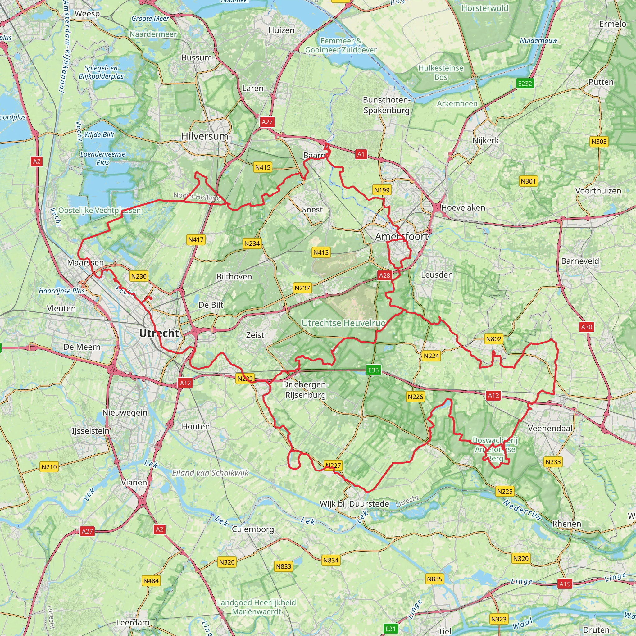
The Utrechtpad is a captivating long-distance walking trail that meanders through the heart of the Netherlands, offering a unique blend of urban and natural landscapes. Spanning approximately 153 kilometers (about 95 miles) with an elevation gain of around 400 meters (roughly 1312 feet), this loop trail begins and ends near the historic city of Utrecht, making it an accessible adventure for those looking to explore the Dutch countryside.
Getting to the Trailhead
To start your journey on the Utrechtpad, you can easily reach the trailhead by public transport or car. Utrecht, being a major city, is well-connected by train from Amsterdam, Rotterdam, and other Dutch cities. Once in Utrecht, local buses can take you closer to the trail's starting point. If driving, there are parking facilities near the trailhead where you can leave your car.
The Trail Experience
As you embark on the Utrechtpad, you'll traverse a variety of terrains, from lush river valleys and dense woodlands to open meadows and picturesque villages. The trail is marked with the characteristic red and white signage, making navigation straightforward. For additional support, HiiKER is an excellent tool to keep you on track with detailed maps and waypoints.
Historical Significance and Landmarks
The Utrechtpad takes you through regions steeped in history. You'll encounter ancient forts, castles, and estates along the way, each telling a story of the Netherlands' rich past. Notable landmarks include the Dom Tower in Utrecht, the medieval Kasteel de Haar, and the fortified town of Naarden, which is a splendid example of a star fort.
Nature and Wildlife
Nature enthusiasts will appreciate the diverse flora and fauna found along the Utrechtpad. The trail passes through the Utrechtse Heuvelrug National Park, a haven for wildlife and home to one of the Netherlands' largest forested areas. Keep an eye out for a variety of bird species, as well as the occasional deer.
Trail Sections and Distances
The Utrechtpad can be divided into manageable sections, allowing hikers to tailor their journey to their fitness level and time constraints. For example, the stretch from Utrecht to Bunnik is about 8 kilometers (5 miles), offering a gentle start to the hike with minimal elevation change. As you progress, each section reveals new landscapes and points of interest, culminating in the return to the vibrant city of Utrecht.
Preparation and Planning
Given the trail's medium difficulty rating, it's suitable for hikers with a moderate level of experience. The terrain is generally flat, but the distance can be challenging. It's advisable to wear comfortable walking shoes and carry a daypack with essentials like water, snacks, and a first-aid kit. The Dutch weather can be unpredictable, so pack layers and waterproof gear.
Accommodations and Amenities
Along the Utrechtpad, there are plenty of opportunities to rest and refuel. The trail passes through towns and villages where you can find accommodations ranging from cozy B&Bs to more luxurious hotels. There are also numerous cafes and restaurants where you can sample local Dutch cuisine.
Conclusion
The Utrechtpad offers a delightful hiking experience that combines natural beauty with cultural and historical richness. Whether you're looking to complete the entire loop or enjoy a shorter section, this trail provides a unique perspective on the Netherlands and its landscapes. With careful planning and a spirit of adventure, the Utrechtpad is sure to be a memorable journey.
Comments and Reviews
User comments, reviews and discussions about the Utrechtpad, Netherlands.
4.71
average rating out of 5
7 rating(s)

