Download
Preview
Add to list
More
205.2 km
~7 days
323 m
Multi-Day
“Embark on the Pionierspad for a scenic Dutch trek through history, nature, and reclaimed landscapes.”
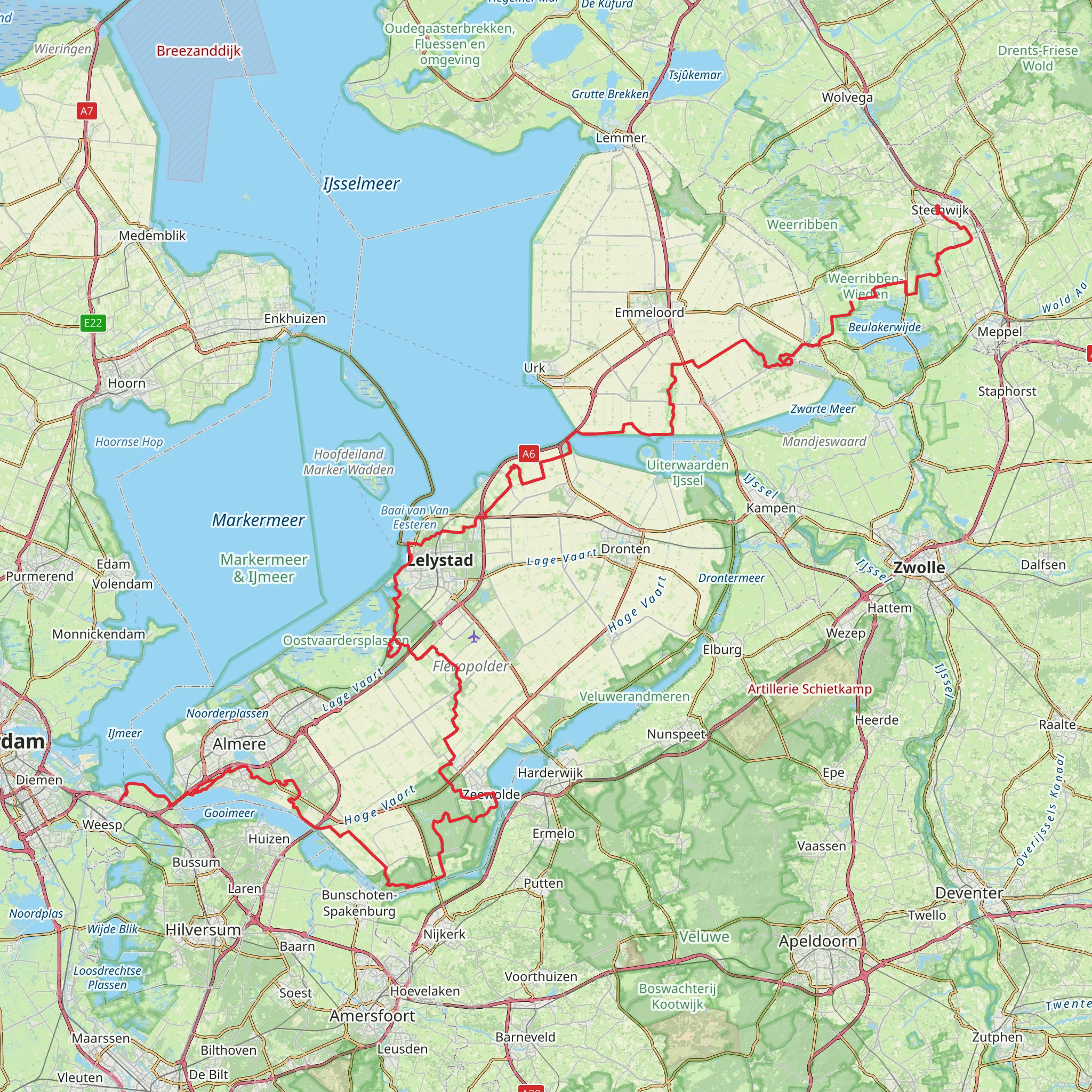
The Pionierspad, also known as the Pioneer's Path, offers a unique journey through the Dutch landscape, stretching approximately 205 kilometers (about 127 miles) with a modest elevation gain of around 300 meters (roughly 984 feet). This point-to-point trail begins near Steenwijkerland in the province of Overijssel and winds its way down to the Muiden area, close to Amsterdam.
Getting to the Trailhead
To reach the starting point near Steenwijkerland, hikers can utilize public transportation by taking a train to Steenwijk station and then a bus to the trailhead. For those driving, parking is available in the vicinity of the starting point. It's advisable to use the HiiKER app for precise navigation to the trailhead and for detailed maps throughout the hike.
Navigating the Pionierspad
The trail is well-marked with the characteristic red and white signage, guiding hikers through a variety of landscapes including peat bogs, farmland, and polder areas – land reclaimed from the sea. The path traverses several nature reserves, offering a chance to observe the rich biodiversity of the region.
Landmarks and Nature
One of the early highlights is the Weerribben-Wieden National Park, a peatland area where hikers can witness a mosaic of water, reed beds, and woodland. This area is home to a diverse array of wildlife, including otters and numerous bird species.
Further along, the trail passes through the historic town of Vollenhove, with its charming streets and old buildings, providing a glimpse into the region's past. The path also takes hikers through the UNESCO World Heritage Site of Schokland, a former island in the Zuiderzee, which tells the story of the Netherlands' ongoing battle with the sea.
Historical Significance
The Pionierspad is steeped in history, with the route itself following ancient footpaths used by pioneers and settlers. The reclaimed lands, or polders, are a testament to the Dutch mastery of water management, and the trail offers an insight into the transformation of the landscape over the centuries.
Preparation and Planning
Given the trail's length, hikers should plan for multiple days of walking, with accommodations ranging from campsites to bed and breakfasts along the route. The flat terrain makes for easier hiking, but the distance still presents a challenge, hence the medium difficulty rating. Weather in the Netherlands can be unpredictable, so waterproof gear and layered clothing are essential. For navigation, the HiiKER app is a valuable tool, providing offline maps and trail information.
Wildlife and Flora
As the trail progresses, the changing scenery includes the open grasslands of the Flevopolder, the largest artificial island in the world, where hikers can enjoy vast skies and the sight of windmills dotting the horizon. Birdwatchers will delight in the variety of species, especially during migration seasons.
Conclusion
In conclusion, the Pionierspad offers a unique hiking experience through the Dutch countryside, rich in history, nature, and cultural heritage. With careful planning and the right tools for navigation, hikers can immerse themselves in the beauty and tranquility of this remarkable trail.
Comments and Reviews
User comments, reviews and discussions about the Pionierspad, Netherlands.
4.14
average rating out of 5
7 rating(s)

