Download
3D Flyover
Add to list
More
24.9 km
~5 hrs 19 min
209 m
Multi-Day
“Embark on a breathtaking 15.5-mile trek through Michigan's wilderness, where history whispers amidst cascading falls and ancient forests.”
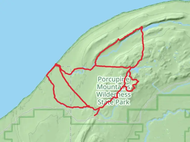
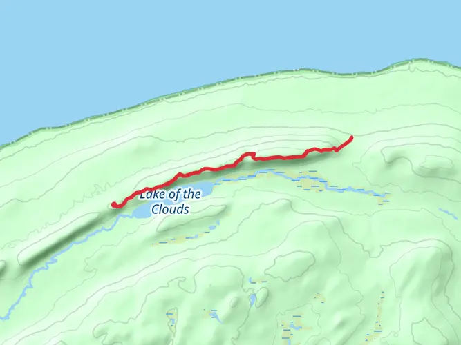
The Porcupine Mountains-Lake Superior Trail is a captivating journey through the rugged wilderness of Michigan's Upper Peninsula. Spanning approximately 25 kilometers (about 15.5 miles) with an elevation gain of around 200 meters (about 656 feet), this point-to-point trail offers hikers a medium difficulty trek that showcases the natural beauty of the region.
Getting to the Trailhead To reach the trailhead near Ontonagon County, Michigan, hikers can drive to the Porcupine Mountains Wilderness State Park. The park is accessible via South Boundary Road, which leads to various entry points. For those relying on public transportation, options are limited, but regional bus services may offer routes to Ontonagon, from where you can arrange a taxi or shuttle service to the park.
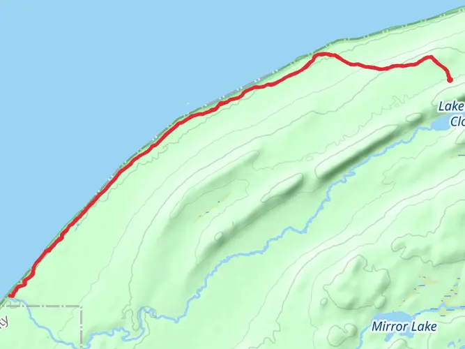
Navigating the Trail The trail begins near the Lake Superior shoreline, where the vastness of the lake sets a serene backdrop for the journey ahead. Hikers can use the HiiKER app to navigate the trail, ensuring they stay on the correct path and can anticipate upcoming changes in terrain or elevation.
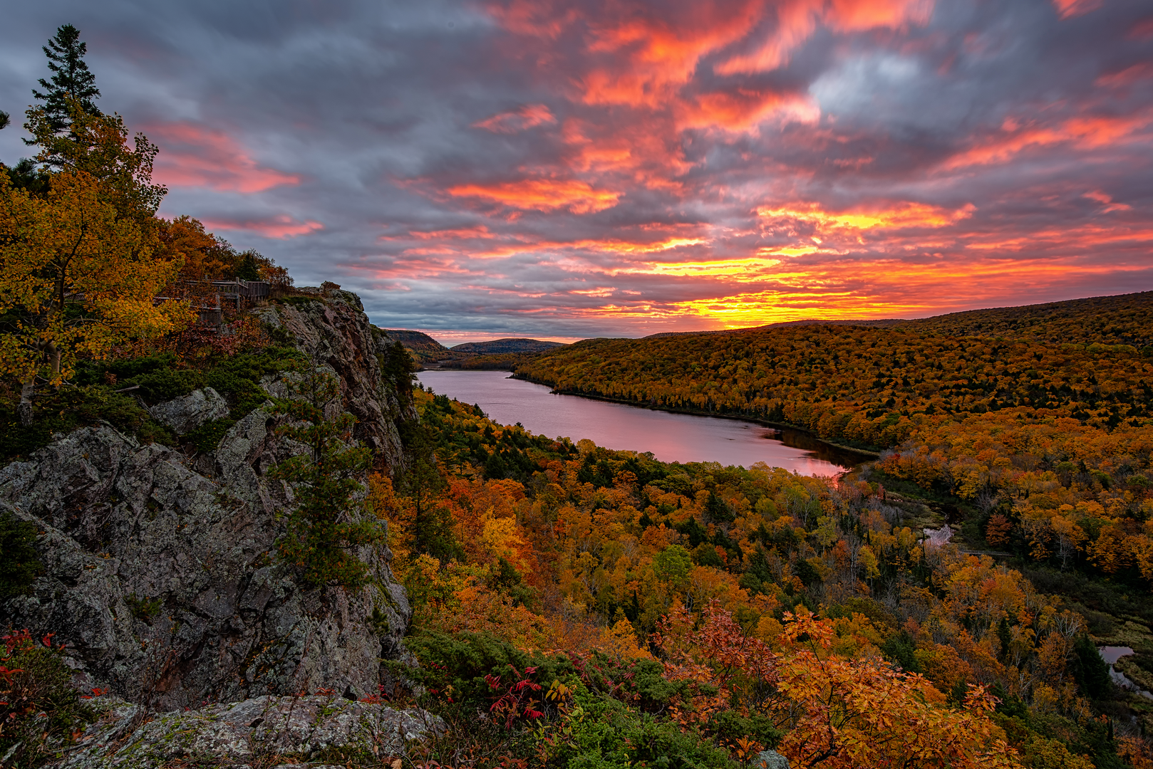
Landmarks and Natural Features As you traverse the trail, you'll encounter a diverse array of landscapes, from dense hardwood forests to serene river valleys. The trail meanders along the Lake Superior shoreline, offering stunning views of the lake's crystal-clear waters and the chance to spot freighters in the distance.
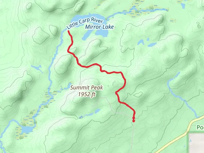
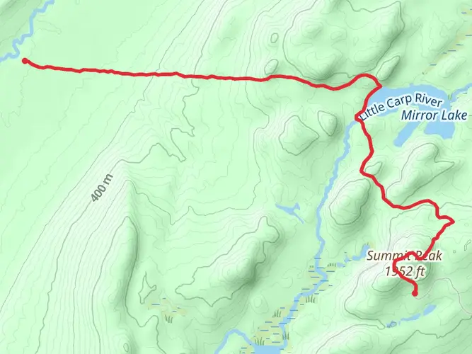
Approximately 5 kilometers (3.1 miles) into the hike, you'll reach the Presque Isle River area, where three stunning waterfalls—Manabezho Falls, Manido Falls, and Nawadaha Falls—can be observed. The rushing waters and surrounding old-growth forests provide a picturesque setting for a rest or a photo opportunity.
Wildlife and Flora The Porcupine Mountains are home to a rich variety of wildlife, including black bears, deer, and moose. Birdwatchers may also spot a range of species, from the majestic bald eagle to the melodic hermit thrush. The trail is lined with a mix of maple, hemlock, and birch trees, and in the spring and summer months, wildflowers such as trilliums and orchids bloom in abundance.
Historical Significance The region is steeped in history, with the Porcupine Mountains formed over a billion years ago. The area was once the territory of the Ojibwa people and later became a site for copper mining in the 19th century. Hikers can reflect on the past as they pass by remnants of these early mining operations.
Preparation and Planning Before setting out, hikers should be prepared for the trail's varying conditions. Weather can change rapidly along Lake Superior, so it's essential to pack layers and waterproof gear. Sturdy hiking boots are recommended, as the terrain can be rocky and uneven in places. It's also wise to bring a map, compass, and the HiiKER app for navigation, as well as sufficient water and food for the journey.
Remember to practice Leave No Trace principles, keeping the wilderness pristine for future visitors. With proper preparation and respect for the natural environment, the Porcupine Mountains-Lake Superior Trail offers an unforgettable hiking experience that captures the wild spirit of Michigan's Upper Peninsula.

What to expect?
Activity types
Frequently asked questions
How long is the Porcupine Mts-Lake Superior Trail and how hard is it?
The Porcupine Mts-Lake Superior Trail is 24.91 kilometers, or about 15.5 miles, with 209 meters of elevation gain. It is listed as an easy multi-day hike, but the shoreline route in Porcupine Mountains Wilderness State Park is still a long point-to-point outing that usually works best for backpackers or hikers arranging a shuttle.
Where does the Porcupine Mts-Lake Superior Trail start and end in Porcupine Mountains Wilderness State Park?
The Lake Superior Trail in the Porkies runs along the Lake Superior shore between the Presque Isle area on the west side of the park and M-107 on the east side. The state park trail description breaks it into sections from Presque Isle to Speaker’s Creek, then past the Little Carp and Big Carp river mouths, continuing east to Lone Rock and M-107.
What are the main landmarks on the Porcupine Mts-Lake Superior Trail?
Key landmarks on the Porcupine Mts-Lake Superior Trail include the Presque Isle area, Speaker’s Creek, the mouths of the Little Carp River and Big Carp River, Lone Rock, and long stretches of Lake Superior shoreline. The route is known for repeated lake views and remote beach-and-forest scenery rather than a single summit destination.
Is the Porcupine Mts-Lake Superior Trail good for a backpacking trip?
Yes. At just under 25 kilometers with a point-to-point layout, the Porcupine Mts-Lake Superior Trail fits well as an overnight backpack in Porcupine Mountains Wilderness State Park. The park manages backcountry camping and requires overnight users to register for backcountry camping, with permits issued through the park’s backcountry system.
Can dogs go on the Porcupine Mts-Lake Superior Trail?
Dogs are generally allowed in Michigan state parks, and the Porcupine Mountains backcountry map specifically notes that pets must be kept leashed on wilderness trails. That means the Porcupine Mts-Lake Superior Trail is not an off-leash route, and dogs need to stay under control throughout the hike.
Where can you park for the Porcupine Mts-Lake Superior Trail?
Parking for the Porcupine Mts-Lake Superior Trail is typically at designated trailhead parking areas inside Porcupine Mountains Wilderness State Park, with common access near Presque Isle and along M-107. Because it is a point-to-point route, many hikers leave a vehicle at one end and arrange a pickup or second car at the other.
Comments and Reviews
User comments, reviews and discussions about the Porcupine Mts-Lake Superior Trail, Michigan.
4.6
average rating out of 5
15 rating(s)