Download
3D Preview
Add to list
More
68.7 km
~3 days
669 m
Multi-Day
“Embark on a scenic 43-mile hike through Pictured Rocks, blending Michigan's history with majestic lakeshore vistas.”
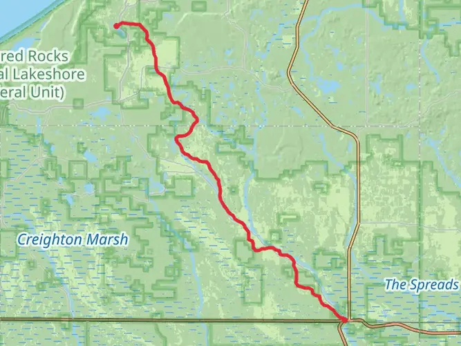
Spanning approximately 43 miles (69 km) with an elevation gain of around 1,968 feet (600 meters), the North Country Trail through Pictured Rocks National Lakeshore offers a remarkable journey through Michigan's Upper Peninsula. This point-to-point trail is nestled near Alger County, Michigan, and is rated as medium difficulty, making it accessible to hikers with a moderate level of experience.
Getting to the Trailhead
The trailhead is conveniently located near the city of Munising, Michigan. For those arriving by car, you can navigate to the eastern terminus of the Pictured Rocks segment near Grand Marais, or start at the western end near Munising. Public transportation options are limited in this rural area, so driving is the most practical way to reach the trailhead. Parking is available at both ends of the trail.
Trail Experience
As you embark on the trail, you'll be greeted by a diverse landscape that includes dense hardwood forests, serene inland lakes, and dramatic sandstone cliffs. The trail meanders along the Lake Superior shoreline, offering breathtaking views of the largest of the Great Lakes.
In the first few miles, you'll encounter a gentle incline as you make your way through mixed forests. Keep an eye out for local wildlife, including white-tailed deer, black bears, and a variety of bird species. The trail is well-marked, but carrying a navigation tool like HiiKER can be helpful for staying on track and identifying nearby landmarks.
Notable Landmarks and Scenery
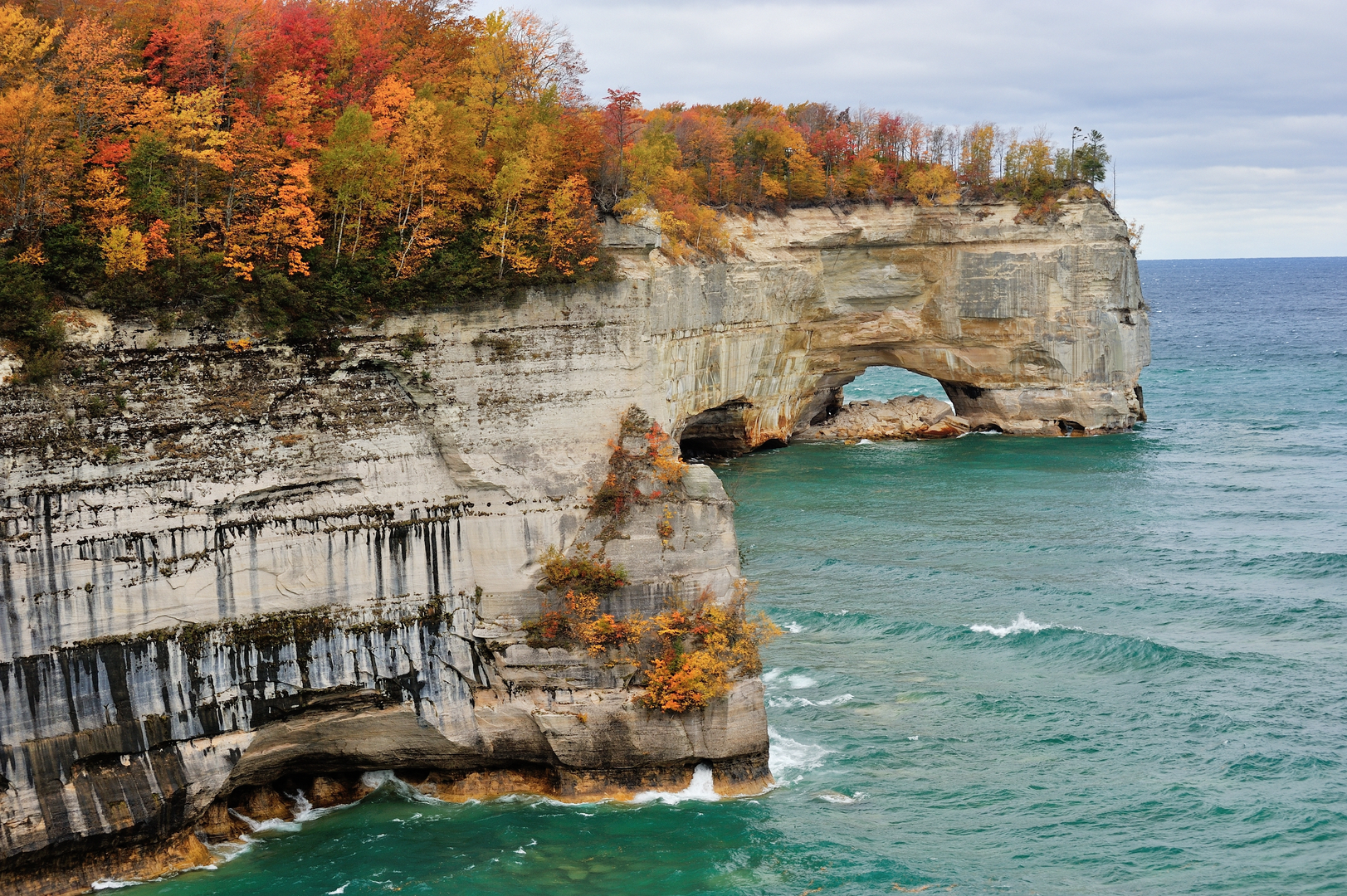
As you progress, you'll reach the iconic Miners Castle, an impressive rock formation that stands as a sentinel over Lake Superior. This natural structure is one of the most photographed features in the park and is located about 6.4 miles (10.3 km) from the Munising trailhead.
Continuing on, the trail offers views of the Au Sable Point Lighthouse, approximately 20 miles (32 km) from the start. This historic lighthouse has guided ships since the late 1800s and is a testament to the maritime history of the Great Lakes.
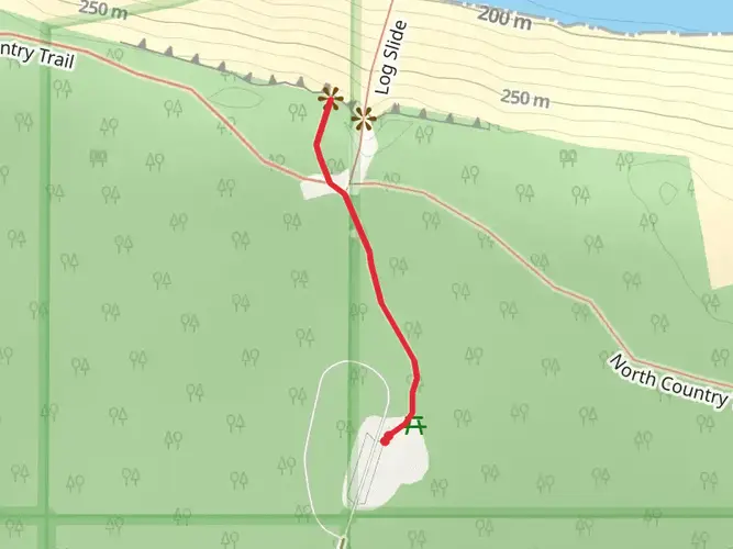
The trail's highest point is near the Log Slide Overlook, where loggers once slid timber down the steep dunes to Lake Superior. This area provides a panoramic vista of the lake and the Grand Sable Dunes.
Trail Conditions and Preparation
The trail surface varies from packed dirt to rocky terrain and wooden boardwalks. Sturdy hiking boots are recommended to navigate the uneven ground comfortably. Weather along the lakeshore can change rapidly, so be prepared with layers and waterproof gear.
Historical Significance
The North Country Trail through Pictured Rocks National Lakeshore traverses a region rich in history. The Ojibwa (Chippewa) people have lived in this area for thousands of years, and European explorers and fur traders began arriving in the 17th century. The park's name, "Pictured Rocks," comes from the streaks of mineral stain that decorate the face of the weathered sandstone cliffs.
Conclusion
Overall, the North Country Trail through Pictured Rocks National Lakeshore is a must-hike for those seeking a mix of natural beauty, historical intrigue, and a moderately challenging trek. With proper planning and respect for the trail's natural and historical significance, hikers will find this journey to be a rewarding experience.

What to expect?
Activity types
Frequently asked questions
How long does the North Country Trail - Rocks National Lake Shore take to hike?
North Country Trail - Rocks National Lake Shore is 68.72 km, or about 42.7 miles, so most backpackers split it into 3 to 5 days. Strong hikers can move faster, but the point-to-point format and time needed for overlooks, beaches, and camp logistics through Pictured Rocks National Lakeshore usually make it a multi-day trip rather than a single long day.
Where do you start and park for the North Country Trail - Rocks National Lake Shore?
The route is commonly started from the Munising side on the west end or near Grand Marais on the east end of Pictured Rocks National Lakeshore. Overnight parking is allowed in Pictured Rocks parking lots with a valid backcountry permit and park pass, which makes end-to-end trips practical for backpackers staging a car at one end.
Do you need a permit to backpack the North Country Trail - Rocks National Lake Shore?
Yes. Overnight trips on the North Country Trail - Rocks National Lake Shore inside Pictured Rocks National Lakeshore require a backcountry camping permit, and campers must stay in designated backcountry campgrounds and assigned numbered sites. Dispersed camping and sleeping in vehicles in parking lots are not allowed in the park.
Is the North Country Trail - Rocks National Lake Shore dog friendly?
No, this is not a good choice for a dog-friendly backpacking trip. Dogs are not permitted on parts of the North Country National Scenic Trail in Pictured Rocks National Lakeshore, and pets are not allowed at any backcountry campground in the park, which rules out a full overnight through-hike with a dog.
What are the main sights on the North Country Trail - Rocks National Lake Shore?
The North Country Trail - Rocks National Lake Shore follows the Pictured Rocks corridor along Lake Superior, where the standout scenery includes multicolored sandstone cliffs, long beaches, inland lakes, waterfalls, and dune country near the Grand Sable area. Well-known landmarks in this section of the park include Miners Castle, Chapel Rock, Grand Portal Point, and the Grand Sable Dunes.
Is the North Country Trail - Rocks National Lake Shore hard?
North Country Trail - Rocks National Lake Shore is generally approachable for a multi-day route, with 669 m of total elevation gain over 68.72 km. The overall grade is not extreme, but the length, sandy stretches, bluff-top walking, and repeated ups and downs along the Lake Superior shoreline still make it a serious backpacking trip that requires stamina and planning.
Is there a shuttle for the North Country Trail - Rocks National Lake Shore?
Yes. Pictured Rocks National Lakeshore notes that shuttle service is available for backpackers and specifically recommends using the shuttle at the beginning of a trip and hiking back to a parked vehicle. That setup works especially well on this point-to-point route between the Munising and Grand Marais sides of the park.
Comments and Reviews
User comments, reviews and discussions about the North Country Trail - Rocks National Lake Shore, Michigan.
4.53
average rating out of 5
15 rating(s)