Download
Preview
Add to list
More
8.0 km
~1 hrs 50 min
145 m
Loop
“Explore a scenic 8 km loop in Sächsische Schweiz with lush gorges, caves, and historical intrigue.”
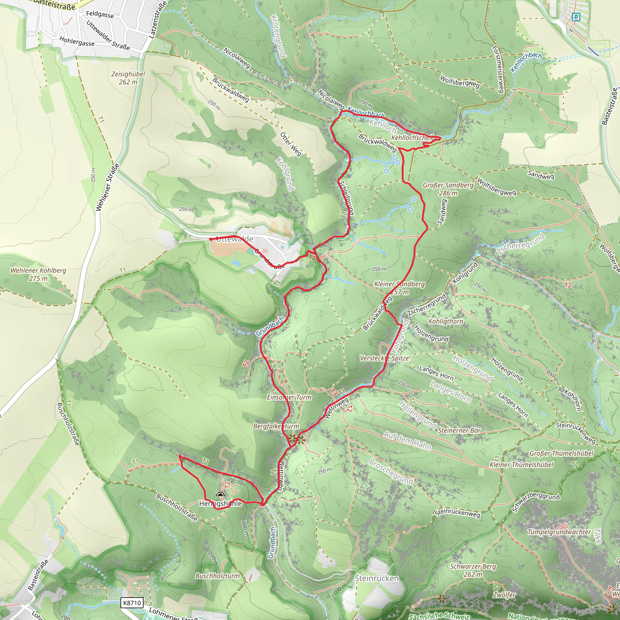
Starting near Sächsische Schweiz-Osterzgebirge in Germany, this 8 km (approximately 5 miles) loop trail offers a delightful mix of natural beauty and historical intrigue. With an elevation gain of around 100 meters (328 feet), the trail is rated as medium difficulty, making it accessible for most hikers with a moderate level of fitness.
Getting There To reach the trailhead, you can either drive or use public transport. If driving, set your GPS to the nearest known address, which is the town of Wehlen. From there, follow the signs to the Sächsische Schweiz National Park. For those using public transport, take a train to the Wehlen station. From the station, it's a short walk to the trailhead.
Trail Highlights
#### Uttewalder Grund The trail begins by leading you into the Uttewalder Grund, a picturesque gorge characterized by its lush greenery and towering rock formations. The path here is relatively flat, making it a good warm-up for the rest of the hike. Keep an eye out for the unique flora that thrives in this shaded, moist environment, including various species of ferns and mosses.
#### Heringshöhle About 3 km (1.9 miles) into the hike, you'll reach Heringshöhle, a fascinating cave that has been shaped by centuries of natural erosion. The cave is named after the herring, although you won't find any fish here; the name is a historical relic. This section of the trail involves a slight ascent, adding about 50 meters (164 feet) to your elevation gain. The cave is a great spot to take a break and explore the intriguing rock formations.
#### Kohlgrund Continuing on, the trail takes you through the Kohlgrund area, another scenic gorge that offers a different but equally captivating landscape. This part of the trail is slightly more challenging, with a few steeper sections that will get your heart rate up. The elevation gain here is around 50 meters (164 feet), bringing the total to approximately 100 meters (328 feet) for the entire hike. The Kohlgrund is known for its rich biodiversity, so keep your eyes peeled for various bird species and small mammals.
Historical Significance The region of Sächsische Schweiz has a rich history, dating back to prehistoric times. The rock formations and caves have been used as shelters and fortifications throughout the centuries. During the Middle Ages, the area was a hotspot for mining activities, particularly for silver and other precious metals. The remnants of these historical activities can still be seen along the trail, adding an extra layer of intrigue to your hike.
Navigation and Safety For navigation, it's highly recommended to use the HiiKER app, which provides detailed maps and real-time updates. The trail is well-marked, but having a reliable navigation tool will ensure you stay on track. Wear sturdy hiking boots, as some sections can be slippery, especially after rain. Bring plenty of water and snacks, as there are no facilities along the trail.
Wildlife and Flora The trail is a haven for nature enthusiasts. In addition to the diverse plant life, you may encounter various wildlife species. Common sightings include deer, foxes, and a variety of bird species such as woodpeckers and owls. The flora is equally impressive, with ancient trees, wildflowers, and unique rock formations covered in moss and lichens.
This 8 km loop offers a perfect blend of natural beauty, moderate physical challenge, and historical significance, making it a must-visit for any hiking enthusiast.
What to expect?
Activity types
Comments and Reviews
User comments, reviews and discussions about the Uttewalder Grund, Heringshöhle and Kohlgrund Loop, Germany.
4.33
average rating out of 5
3 rating(s)

