Download
Preview
Add to list
More
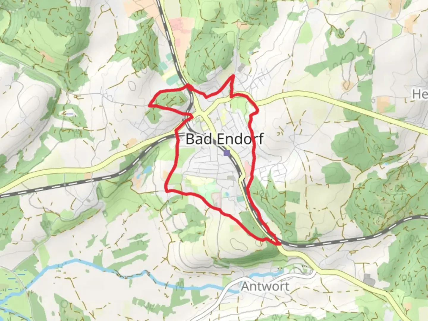
7.0 km
~1 hrs 35 min
110 m
Loop
“The Panoramaweg Bad Endorf is a scenic, moderately challenging 7 km trail showcasing Bavaria's natural and historical beauty.”
Starting near the charming town of Bad Endorf, close to Rosenheim, Germany, the Panoramaweg Bad Endorf is a delightful loop trail that spans approximately 7 km (4.35 miles) with an elevation gain of around 100 meters (328 feet). This trail is rated as medium difficulty, making it accessible for most hikers with a moderate level of fitness.
Getting There To reach the trailhead, you can either drive or use public transport. If you're driving, set your GPS to Bad Endorf, and you'll find ample parking options near the town center. For those using public transport, take a train to Bad Endorf station, which is well-connected to major cities like Munich and Rosenheim. From the station, it's a short walk to the trailhead.
Trail Navigation For navigation, it's highly recommended to use the HiiKER app, which provides detailed maps and real-time updates to ensure you stay on track.
Trail Highlights As you embark on the Panoramaweg Bad Endorf, you'll be greeted by a variety of landscapes, from lush meadows to dense forests. The trail offers stunning panoramic views of the Chiemgau Alps and the surrounding Bavarian countryside, which are particularly breathtaking on clear days.
#### Significant Landmarks - Chiemsee Lake: Approximately 2 km (1.24 miles) into the hike, you'll catch glimpses of Chiemsee, Bavaria's largest lake, often referred to as the "Bavarian Sea." The lake's shimmering waters and the distant outline of Herrenchiemsee Castle add a touch of historical grandeur to the scenery. - Therme Bad Endorf: Around the 4 km (2.48 miles) mark, you'll pass near the renowned Therme Bad Endorf, a thermal spa known for its healing waters. While not directly on the trail, it's a great spot to relax and rejuvenate after your hike. - Hofstätter See: At approximately 5 km (3.1 miles), you'll encounter Hofstätter See, a serene lake surrounded by lush greenery. It's an ideal spot for a short break, where you can enjoy the tranquility and perhaps spot some local wildlife.
Flora and Fauna The trail is rich in biodiversity. In the spring and summer months, the meadows are adorned with wildflowers, attracting a variety of butterflies and bees. The forested sections are home to deer, foxes, and a plethora of bird species, making it a haven for nature enthusiasts and bird watchers.
Historical Significance The region around Bad Endorf has a rich history dating back to Roman times. The nearby Chiemsee Lake was a significant trade route, and remnants of Roman settlements have been discovered in the area. The trail itself passes through several historical landmarks, including old farmhouses and chapels that offer a glimpse into the region's past.
Practical Tips - **Footwear**: Given the mixed terrain, sturdy hiking boots are recommended. - **Weather**: The trail can be muddy after rain, so check the weather forecast and dress accordingly. - **Supplies**: Carry enough water and snacks, as there are limited facilities along the trail. - **Wildlife**: Keep an eye out for local wildlife, but remember to maintain a respectful distance.
The Panoramaweg Bad Endorf offers a perfect blend of natural beauty, historical intrigue, and moderate physical challenge, making it a rewarding experience for hikers of all levels.

Comments and Reviews
User comments, reviews and discussions about the Panoramaweg Bad Endorf, Germany.
4.2
average rating out of 5
5 rating(s)