Download
Preview
Add to list
More
3.7 km
~1 hrs 22 min
382 m
Loop
“Explore Bavarian Alps' beauty on a 4 km loop with alpine meadows, historic huts, and panoramic views.”
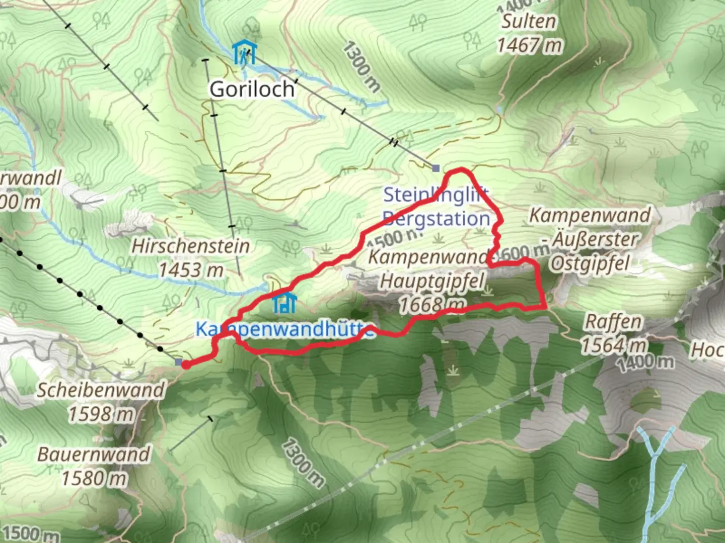
Starting near the picturesque town of Rosenheim, Germany, the Kampenwandhutte and Bergwachthtt via Kampenwandsteig trail offers a delightful 4 km (2.5 miles) loop with an elevation gain of approximately 300 meters (984 feet). This medium-difficulty trail is perfect for those looking to experience the beauty of the Bavarian Alps without committing to a full-day hike.### Getting There To reach the trailhead, you can either drive or use public transportation. If you're driving, head towards Aschau im Chiemgau, which is the nearest significant landmark. There are parking facilities available near the Kampenwandbahn cable car station. For those using public transport, take a train to Prien am Chiemsee and then a bus to Aschau im Chiemgau. From there, it's a short walk to the trailhead.### Trail Overview The trail begins near the Kampenwandbahn cable car station, making it easily accessible. As you start your hike, you'll be greeted by lush alpine meadows and the distant sound of cowbells, a quintessential Bavarian experience. The initial part of the trail is relatively gentle, allowing you to ease into the hike.### Significant Landmarks and Nature At around the 1 km (0.6 miles) mark, you'll reach the Kampenwandhutte, a charming mountain hut where you can take a short break and enjoy some traditional Bavarian snacks. The hut offers stunning views of the surrounding peaks and valleys, making it a perfect spot for photography.Continuing on, the trail becomes steeper as you approach the Kampenwandsteig. This section is more challenging but rewards you with panoramic views of the Chiemsee lake and the distant Austrian Alps. Keep an eye out for local wildlife, including chamois and marmots, which are often seen in this area.### Historical Significance The Kampenwand region has a rich history dating back to medieval times. The name "Kampenwand" itself is derived from the Old High German word "kamp," meaning "field" or "battlefield." The area was historically significant as a strategic lookout point and has numerous legends associated with it. As you hike, you'll come across several informational plaques detailing the history and folklore of the region.### Navigation and Safety Given the varying terrain, it's advisable to use a reliable navigation tool like HiiKER to stay on track. The trail is well-marked, but having a digital map can be reassuring, especially in foggy conditions. Make sure to wear sturdy hiking boots and bring layers, as the weather can change rapidly in the mountains.### Final Stretch As you descend, you'll pass by the Bergwachthtt, another mountain hut that serves as a base for the local mountain rescue team. This is a good spot to rest and perhaps chat with the friendly staff about the region's history and wildlife. The final stretch of the trail takes you through dense forests before looping back to the trailhead near the Kampenwandbahn cable car station.This trail offers a perfect blend of natural beauty, historical significance, and moderate physical challenge, making it a must-visit for any hiking enthusiast exploring the Bavarian Alps.

What to expect?
Activity types
Comments and Reviews
User comments, reviews and discussions about the Kampenwandhutte and Bergwachthtt via Kampenwandsteig, Germany.
4.33
average rating out of 5
6 rating(s)