Download
Preview
Add to list
More
14.1 km
~4 hrs 56 min
1275 m
Loop
“The Sattel-Böser Tritt and Aggenstein Loop offers a stunning, challenging 14 km hike with panoramic Alpine views.”
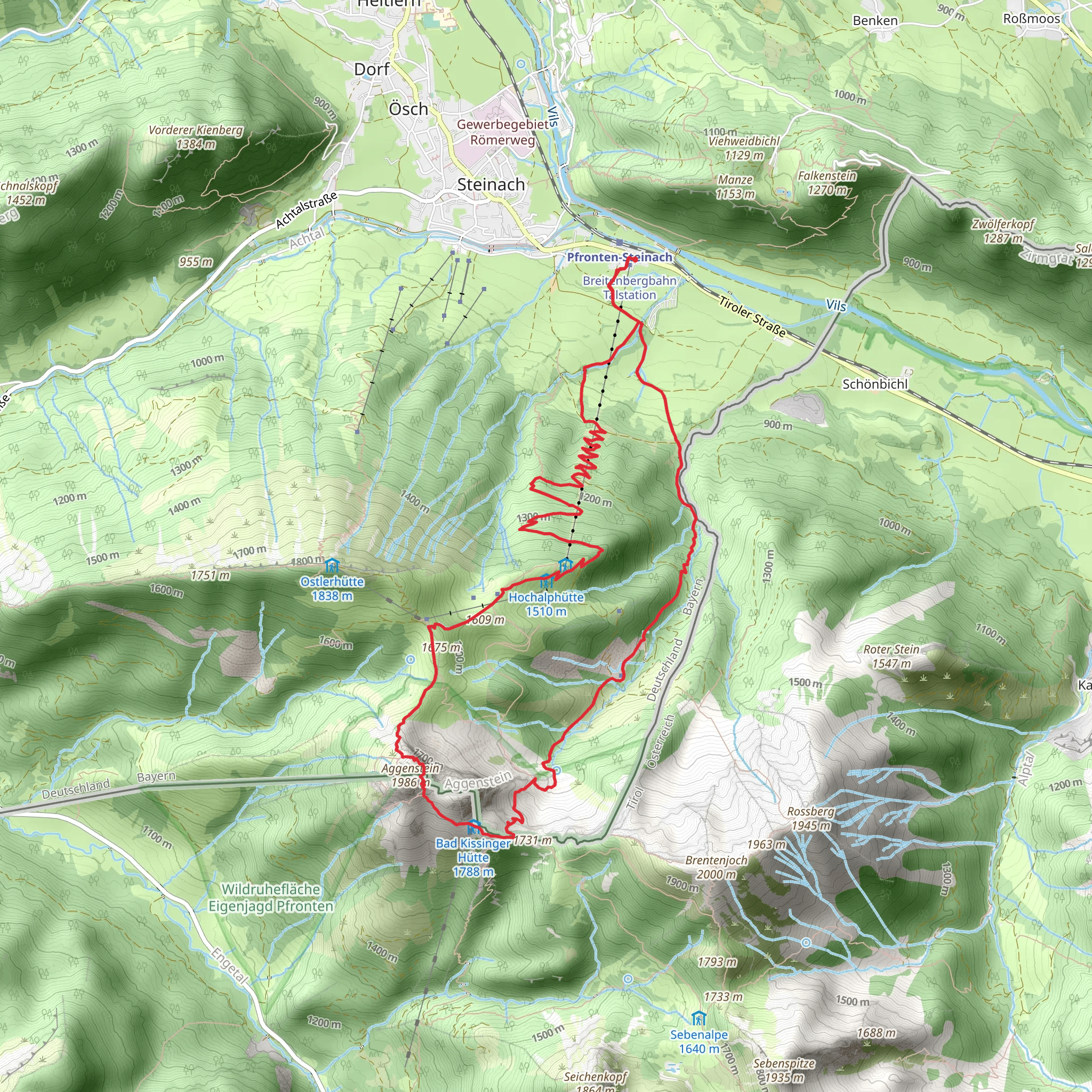
Starting your adventure near Ostallgäu, Germany, the Sattel-Böser Tritt and Aggenstein Loop from Pfronten-Steinach is a captivating 14 km (8.7 miles) loop trail with an elevation gain of approximately 1200 meters (3937 feet). This medium-difficulty hike offers a blend of natural beauty, historical significance, and challenging terrain.### Getting There To reach the trailhead, you can either drive or use public transport. If you're driving, head towards Pfronten-Steinach, where parking is available near the trailhead. For those using public transport, take a train to Pfronten-Steinach station, which is well-connected from major cities like Munich and Augsburg. From the station, it's a short walk to the starting point of the trail.### Trail Overview The trail begins with a gentle ascent through lush forests, offering a serene start to your hike. As you progress, the path becomes steeper, leading you to the first significant landmark, the Sattel. This saddle-like formation provides stunning views of the surrounding valleys and peaks.### Böser Tritt Section Approximately 5 km (3.1 miles) into the hike, you'll encounter the Böser Tritt section. This part of the trail is known for its rocky terrain and requires careful navigation. The use of HiiKER is highly recommended to ensure you stay on the correct path. The Böser Tritt, translating to "Evil Step," is a narrow, rocky passage that demands attention and caution. Despite its name, it offers some of the most breathtaking views of the hike.### Aggenstein Ascent Continuing from Böser Tritt, the trail ascends towards the Aggenstein peak. This section is about 3 km (1.9 miles) long and involves a steep climb. The Aggenstein, standing at 1985 meters (6512 feet), is a prominent peak in the Allgäu Alps. The summit offers panoramic views of the German and Austrian Alps, making the challenging ascent worthwhile.### Flora and Fauna The trail is rich in biodiversity. As you hike, you'll pass through alpine meadows adorned with wildflowers, especially vibrant during the spring and summer months. Keep an eye out for local wildlife, including chamois, marmots, and a variety of bird species. The forests are home to deer and, occasionally, you might spot a fox.### Historical Significance The region around Pfronten-Steinach has a rich history. The trail itself passes near several historical landmarks, including remnants of old border fortifications between Germany and Austria. These fortifications date back to the 19th century and offer a glimpse into the region's past.### Descent and Return After enjoying the views from Aggenstein, the trail descends back towards Pfronten-Steinach. The descent is less strenuous but requires careful footing, especially in wet conditions. The final 4 km (2.5 miles) of the trail take you through picturesque valleys and forests, gradually leading you back to the trailhead.### Practical Tips - Weather: The weather in the Alps can be unpredictable. It's advisable to check the forecast before starting your hike and be prepared for sudden changes. - Gear: Sturdy hiking boots, trekking poles, and a good map or navigation tool like HiiKER are essential. - Water and Snacks: Carry enough water and high-energy snacks, as there are limited places to refill along the trail. - Safety: Inform someone about your hiking plans and estimated return time. Mobile reception can be spotty in certain areas.This trail offers a perfect blend of natural beauty, challenging terrain, and historical intrigue, making it a must-visit for any hiking enthusiast.
What to expect?
Activity types
Comments and Reviews
User comments, reviews and discussions about the Sattel-Böser Tritt and Aggenstein Loop from Pfronten-Steinach, Germany.
4.67
average rating out of 5
9 rating(s)

