Download
Preview
Add to list
More
12.8 km
~3 hrs 41 min
684 m
Loop
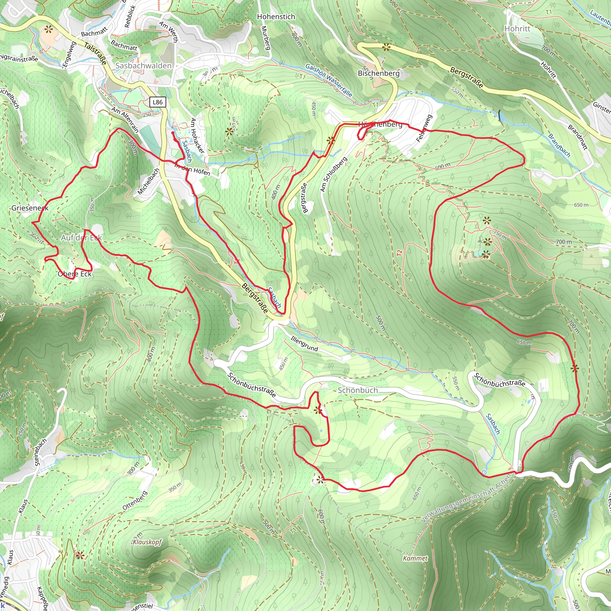
“Discover the enchanting Schnapsbrunnenweg 2 trail, a 13 km loop through the scenic Black Forest with historic schnapps fountains.”
Starting near Ortenaukreis, Germany, the Schnapsbrunnenweg 2 trail offers a delightful 13 km (8 miles) loop with an elevation gain of approximately 600 meters (1,970 feet). This medium-difficulty trail is perfect for those looking to immerse themselves in the scenic beauty of the Black Forest region.### Getting There To reach the trailhead, you can drive to Ortenaukreis, where parking is available near the starting point. If you prefer public transport, take a train to Offenburg and then a local bus to the nearest stop in Ortenaukreis. From there, it's a short walk to the trailhead.### Trail Highlights The trail begins with a gentle ascent through dense forest, where you'll be greeted by the soothing sounds of nature. As you climb, keep an eye out for the diverse flora and fauna that call this area home. The Black Forest is known for its rich biodiversity, including deer, foxes, and a variety of bird species.### Historical Significance Around the 3 km (1.9 miles) mark, you'll come across the first of several "Schnapsbrunnen" or schnapps fountains. These unique landmarks are a nod to the region's history of schnapps production, offering hikers a taste of locally distilled spirits. Historically, these fountains were used by farmers and travelers to quench their thirst and enjoy a moment of relaxation.### Scenic Views As you reach the halfway point, approximately 6.5 km (4 miles) in, the trail opens up to stunning panoramic views of the surrounding valleys and hills. This is an excellent spot to take a break and soak in the breathtaking scenery. The elevation gain here is around 300 meters (985 feet), making it a rewarding climb.### Navigation and Safety The trail is well-marked, but it's always a good idea to have a reliable navigation tool like HiiKER to ensure you stay on track. The path can be slippery after rain, so sturdy hiking boots with good grip are recommended. Also, bring plenty of water and snacks, as there are limited facilities along the route.### Flora and Fauna Continuing on, the trail meanders through a mix of coniferous and deciduous forests. In spring and summer, the forest floor is carpeted with wildflowers, adding a splash of color to your hike. Keep your eyes peeled for the elusive Black Forest cuckoo, whose distinctive call can often be heard echoing through the trees.### Final Stretch The last 3 km (1.9 miles) of the trail descend gradually back towards the starting point. This section offers a peaceful walk through meadows and small streams, providing a serene end to your hike. The total elevation gain for this section is around 100 meters (328 feet), making it a gentle descent.### Practical Tips - Best Time to Hike: Spring to early autumn for the best weather and trail conditions. - What to Bring: Water, snacks, a map or navigation tool like HiiKER, and appropriate clothing for changing weather conditions. - Wildlife Caution: While wildlife encounters are rare, it's always good to be aware of your surroundings and respect the natural habitat.This trail offers a perfect blend of natural beauty, historical intrigue, and moderate physical challenge, making it a must-visit for any hiking enthusiast exploring the Black Forest region.
Comments and Reviews
User comments, reviews and discussions about the Schnapsbrunnenweg 2, Germany.
4.86
average rating out of 5
7 rating(s)

