Download
Preview
Add to list
More
Trail length
12.4 km
Time
~3 hrs 30 min
Elevation Gain
616 m
Hike Type
Loop
“Embark on the Schönberg-Alpe and Schwarzenberg Loop for breathtaking views, wildlife, and historical intrigue.”
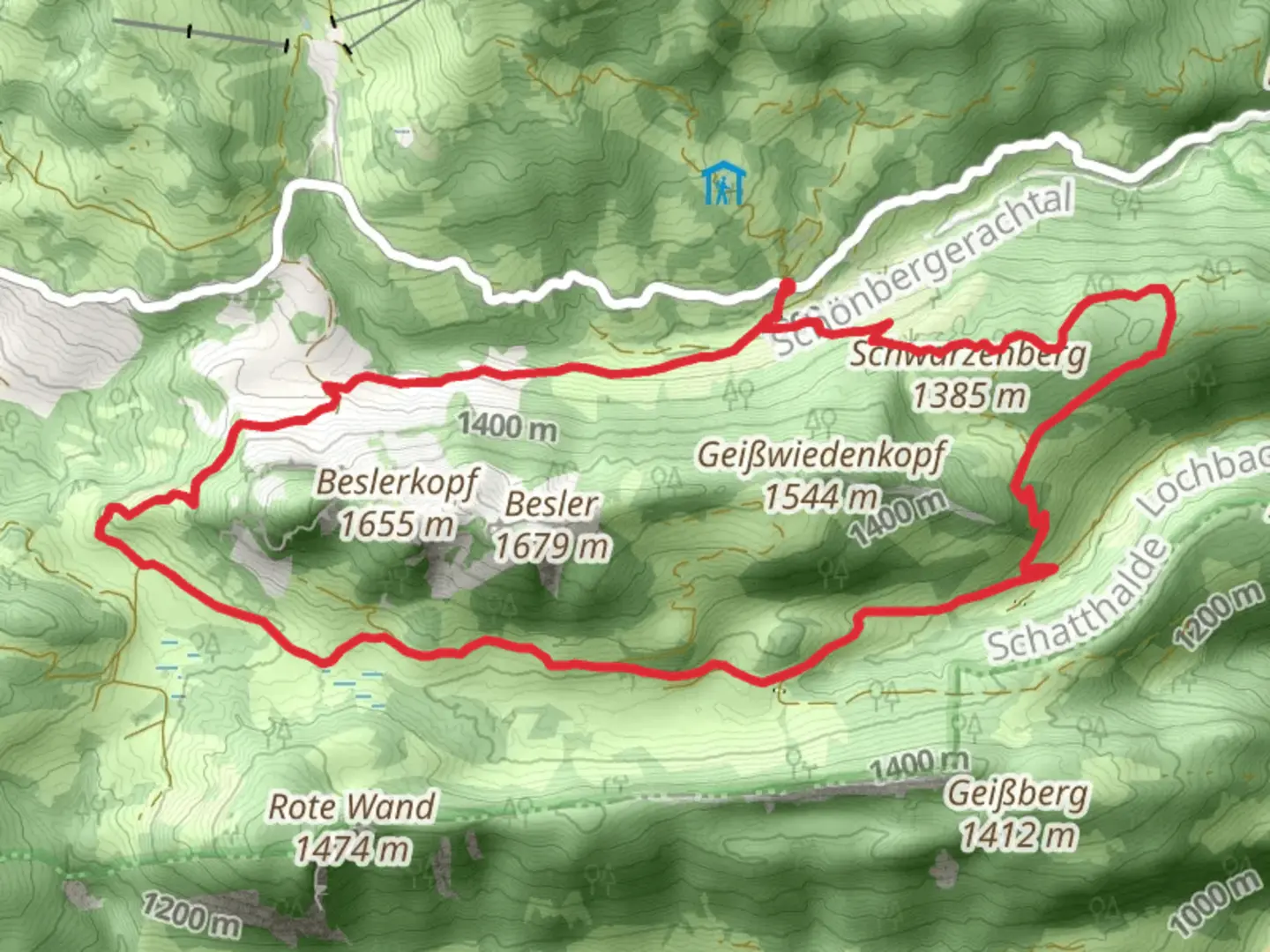
Starting near Oberallgäu, Germany, the Schönberg-Alpe and Schwarzenberg Loop via Beslerrunde is a captivating 12 km (7.5 miles) loop trail with an elevation gain of approximately 600 meters (1,970 feet). This medium-difficulty trail offers a blend of natural beauty, historical significance, and diverse wildlife, making it a rewarding experience for hikers.
Getting There To reach the trailhead, you can either drive or use public transport. If driving, head towards Oberallgäu and look for parking near the village of Riezlern, which is the closest significant landmark. For those using public transport, take a train to Oberstdorf and then a bus to Riezlern. From Riezlern, the trailhead is a short walk away.
Trail Overview The trail begins with a gentle ascent through lush meadows and dense forests, offering a serene start to your hike. As you progress, the path becomes steeper, leading you up to the Schönberg-Alpe. This section is approximately 4 km (2.5 miles) into the hike and involves an elevation gain of about 300 meters (985 feet). The views from Schönberg-Alpe are breathtaking, with panoramic vistas of the Allgäu Alps.
Schönberg-Alpe to Schwarzenberg From Schönberg-Alpe, the trail continues towards Schwarzenberg. This segment is around 3 km (1.9 miles) and includes a mix of ascents and descents, with an additional elevation gain of 150 meters (490 feet). Along the way, you'll encounter alpine flora and fauna, including wildflowers and possibly marmots. Keep an eye out for the diverse bird species that inhabit this region.
Historical Significance The area around Schwarzenberg holds historical significance, with remnants of old alpine farming practices visible along the trail. These historical markers offer a glimpse into the traditional way of life in the Allgäu region. The Schwarzenberg itself is a notable landmark, providing stunning views and a sense of accomplishment as you reach its summit.
Beslerrunde Loop The final section of the trail is the Beslerrunde loop, which brings you back to your starting point. This part of the hike is approximately 5 km (3.1 miles) and involves a descent of about 150 meters (490 feet). The path winds through picturesque landscapes, including rolling hills and tranquil streams. This section is relatively easier, allowing you to enjoy the natural beauty at a more relaxed pace.
Navigation and Safety For navigation, it is highly recommended to use the HiiKER app, which provides detailed maps and real-time updates. The trail is well-marked, but having a reliable navigation tool ensures you stay on track. Be prepared for changing weather conditions, as the alpine climate can be unpredictable. Carry sufficient water, snacks, and a first-aid kit.
Wildlife and Flora Throughout the hike, you'll encounter a variety of wildlife and flora. The meadows are often dotted with colorful wildflowers, and the forests are home to deer, foxes, and a variety of bird species. The alpine environment supports unique plant species, making it a botanist's delight.
Final Stretch As you complete the loop and return to the trailhead near Riezlern, take a moment to reflect on the diverse landscapes and historical elements you've encountered. The Schönberg-Alpe and Schwarzenberg Loop via Beslerrunde offers a rich tapestry of natural beauty, wildlife, and cultural history, making it a memorable hiking experience.

What to expect?
forest
rivers
scenic-views
wildflowers
wildlife
Activity types
hiking
Comments and Reviews
User comments, reviews and discussions about the Schönberg-Alpe and Schwarzenberg Loop via Beslerrunde, Germany.
4.5
average rating out of 5
6 rating(s)