Download
Preview
Add to list
More
8.4 km
~2 hrs 5 min
249 m
Loop
“Explore Miltenberg's scenic 8 km loop trail, blending lush forests, panoramic views, and historical landmarks.”
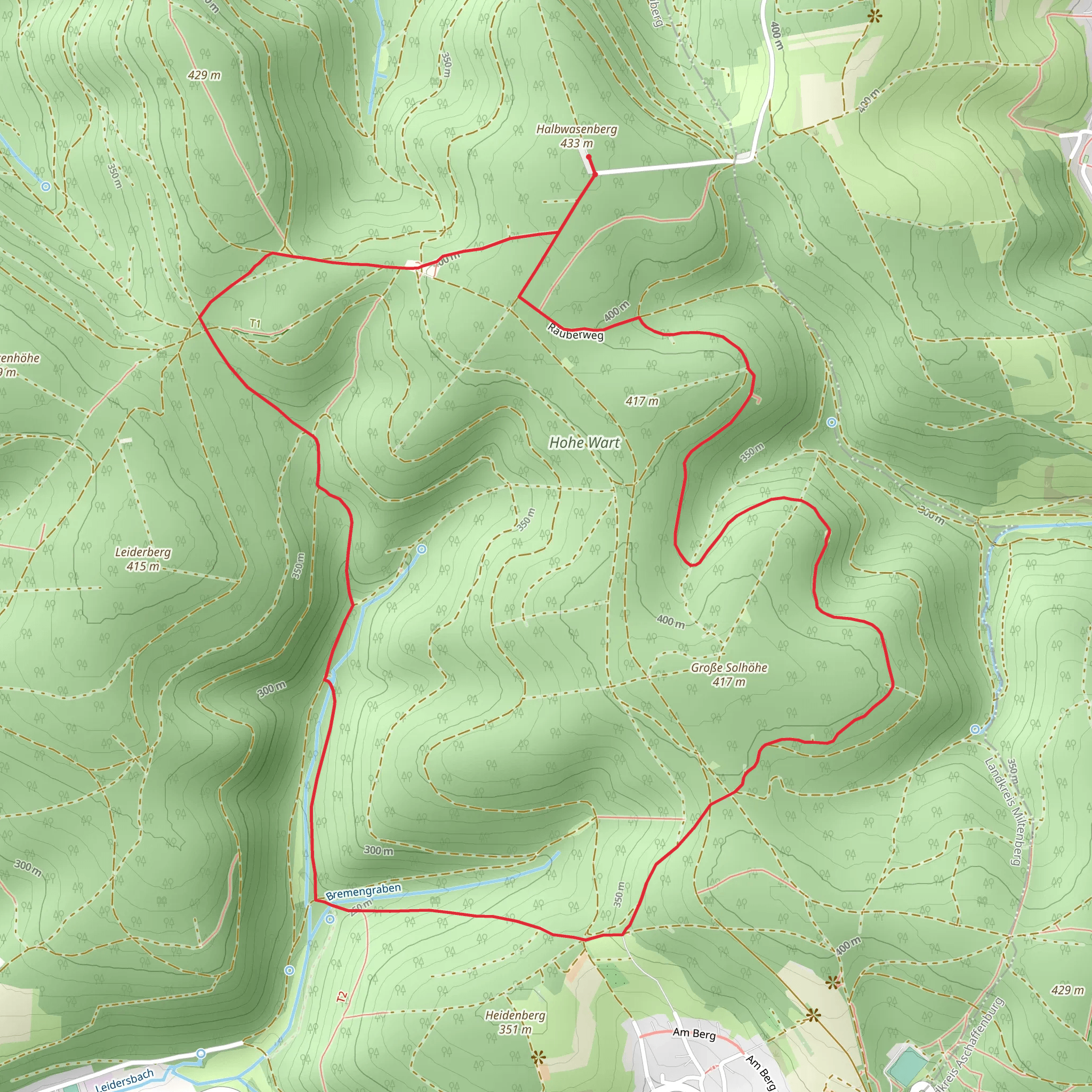
Starting near the picturesque town of Miltenberg, Germany, the Hohe Wart, Solhohe, and Weißes Bild Loop is an 8 km (approximately 5 miles) trail with an elevation gain of around 200 meters (656 feet). This loop trail is rated as medium difficulty, making it suitable for moderately experienced hikers.
Getting There To reach the trailhead, you can either drive or use public transport. If you're driving, head towards Miltenberg and look for parking near the town center or at designated trailhead parking areas. For those using public transport, Miltenberg is well-connected by train. From the Miltenberg train station, it's a short walk to the trailhead, which is conveniently located near the town center.
Trail Overview The trail begins with a gentle ascent through lush forests, offering a serene start to your hike. As you progress, you'll encounter a mix of forested paths and open meadows, providing a variety of landscapes to enjoy. The initial climb is steady but manageable, gaining approximately 100 meters (328 feet) in the first 2 km (1.2 miles).
Key Landmarks and Points of Interest - **Hohe Wart**: At around the 3 km (1.8 miles) mark, you'll reach Hohe Wart, a notable high point on the trail. This area offers stunning views of the surrounding countryside and is a great spot for a short break. - **Solhohe**: Continuing on, you'll come to Solhohe, another elevated area with panoramic views. This section of the trail is particularly scenic, with rolling hills and expansive vistas. - **Weißes Bild**: Around the 6 km (3.7 miles) mark, you'll encounter Weißes Bild, a historical landmark featuring a white cross. This site has cultural and historical significance, often visited by locals for its spiritual importance.
Flora and Fauna The trail is rich in biodiversity. In the forested sections, you might spot deer, foxes, and a variety of bird species. The meadows are home to wildflowers, butterflies, and other pollinators, making spring and summer particularly vibrant times to hike.
Navigation and Safety While the trail is well-marked, it's always a good idea to have a reliable navigation tool. The HiiKER app is highly recommended for this purpose, providing detailed maps and real-time location tracking. Ensure you have adequate water, snacks, and appropriate footwear, as some sections can be uneven and rocky.
Historical Significance Miltenberg itself is steeped in history, with its origins dating back to Roman times. The trail passes through areas that have been historically significant for centuries, including ancient trade routes and spiritual sites like Weißes Bild. The town of Miltenberg is known for its well-preserved medieval architecture, making it worth exploring before or after your hike.
Final Stretch The final 2 km (1.2 miles) of the trail descend gradually back towards Miltenberg, offering a pleasant and easy finish to your hike. This section winds through more forested areas, eventually leading you back to the trailhead near the town center.
This loop trail offers a perfect blend of natural beauty, moderate challenge, and historical intrigue, making it a rewarding experience for any hiker.
What to expect?
Activity types
Comments and Reviews
User comments, reviews and discussions about the Hohe Wart, Solhohe and WEißes Bild Loop, Germany.
average rating out of 5
0 rating(s)

