Download
Preview
Add to list
More
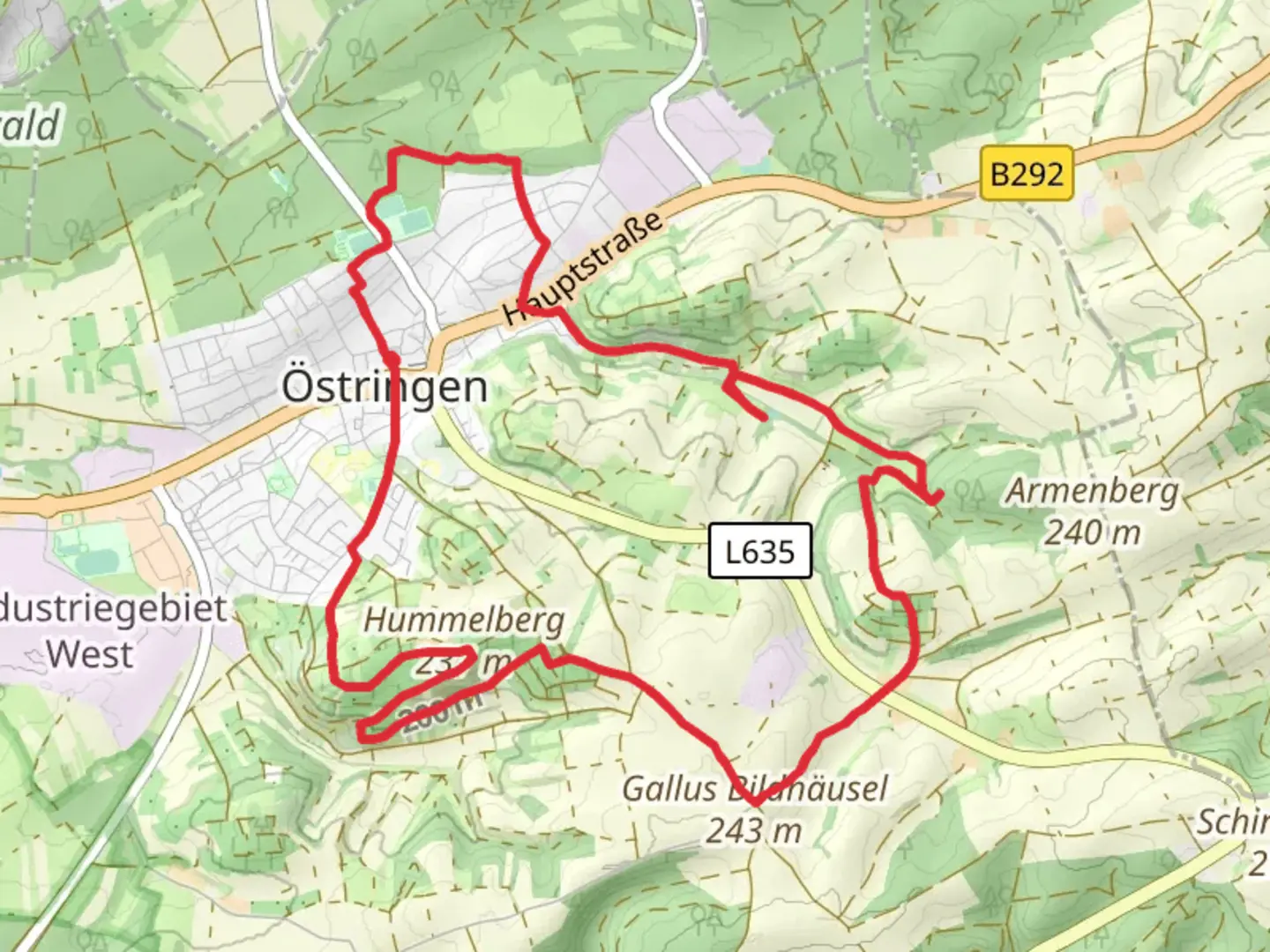
11.5 km
~2 hrs 37 min
199 m
Loop
“Explore natural springs, geological wonders, and historical sites on the captivating Brunnenweg - Geopfad Oestringen trail.”
Starting near Karlsruhe, Germany, the Brunnenweg - Geopfad Oestringen trail is a captivating 11 km (approximately 6.8 miles) loop with an elevation gain of around 200 meters (656 feet). This medium-difficulty trail offers a blend of natural beauty, geological wonders, and historical significance, making it a rewarding experience for hikers.### Getting There To reach the trailhead, you can drive or use public transport. If driving, head towards Oestringen, a town located about 30 km (18.6 miles) southeast of Karlsruhe. Parking is available near the trailhead. For those using public transport, take a train to Karlsruhe Hauptbahnhof (main station) and then a regional bus to Oestringen. The nearest significant landmark to the trailhead is the Oestringen Town Hall.### Trail Highlights
Geological Features
The trail is renowned for its geological path, known as the Geopfad. Along the route, you'll encounter various geological formations that tell the story of the region's ancient past. Look out for information boards that provide insights into the types of rocks and their historical significance. These boards are placed at strategic points, approximately every 1-2 km (0.6-1.2 miles), making it easy to learn as you hike.#### Natural Springs One of the trail's highlights is its numerous natural springs, or "Brunnen," which are scattered throughout the route. These springs are not only picturesque but also historically significant, as they were once vital water sources for the local communities. The most notable springs include the "Kreuzbrunnen" and "Schlossbrunnen," located around the 4 km (2.5 miles) and 7 km (4.3 miles) marks, respectively.### Flora and Fauna The trail meanders through diverse landscapes, including dense forests, open meadows, and rolling hills. The forested sections are home to a variety of wildlife, such as deer, foxes, and numerous bird species. In the spring and summer months, the meadows burst into color with wildflowers, attracting butterflies and bees. Keep an eye out for the rare orchids that bloom in certain areas along the trail.### Historical Significance Oestringen and its surrounding areas have a rich history dating back to Roman times. As you hike, you'll come across remnants of ancient settlements and medieval structures. One notable landmark is the ruins of a Roman villa, located about 5 km (3.1 miles) into the hike. This site offers a glimpse into the region's historical significance and its role in ancient trade routes.### Navigation and Safety Given the trail's moderate difficulty, it's advisable to use a reliable navigation tool like HiiKER to stay on track. The trail is well-marked, but having a digital map can be helpful, especially in the denser forest sections. Wear sturdy hiking boots, as some parts of the trail can be rocky and uneven. Carry enough water and snacks, as there are limited facilities along the route.### Final Stretch The last few kilometers of the trail take you through picturesque vineyards, offering stunning views of the surrounding countryside. This section is relatively flat, providing a gentle end to your hike. As you approach the trailhead, you'll pass by the Oestringen Town Hall, where you can take a moment to rest and reflect on your journey.This trail offers a perfect blend of natural beauty, geological wonders, and historical insights, making it a must-visit for any hiking enthusiast.

Comments and Reviews
User comments, reviews and discussions about the Brunnenweg - Geopfad Oestringen, Germany.
average rating out of 5
0 rating(s)