Geigerstein Peak Loop via Maximiliansweg - Lenggries
Download
Preview
Add to list
More
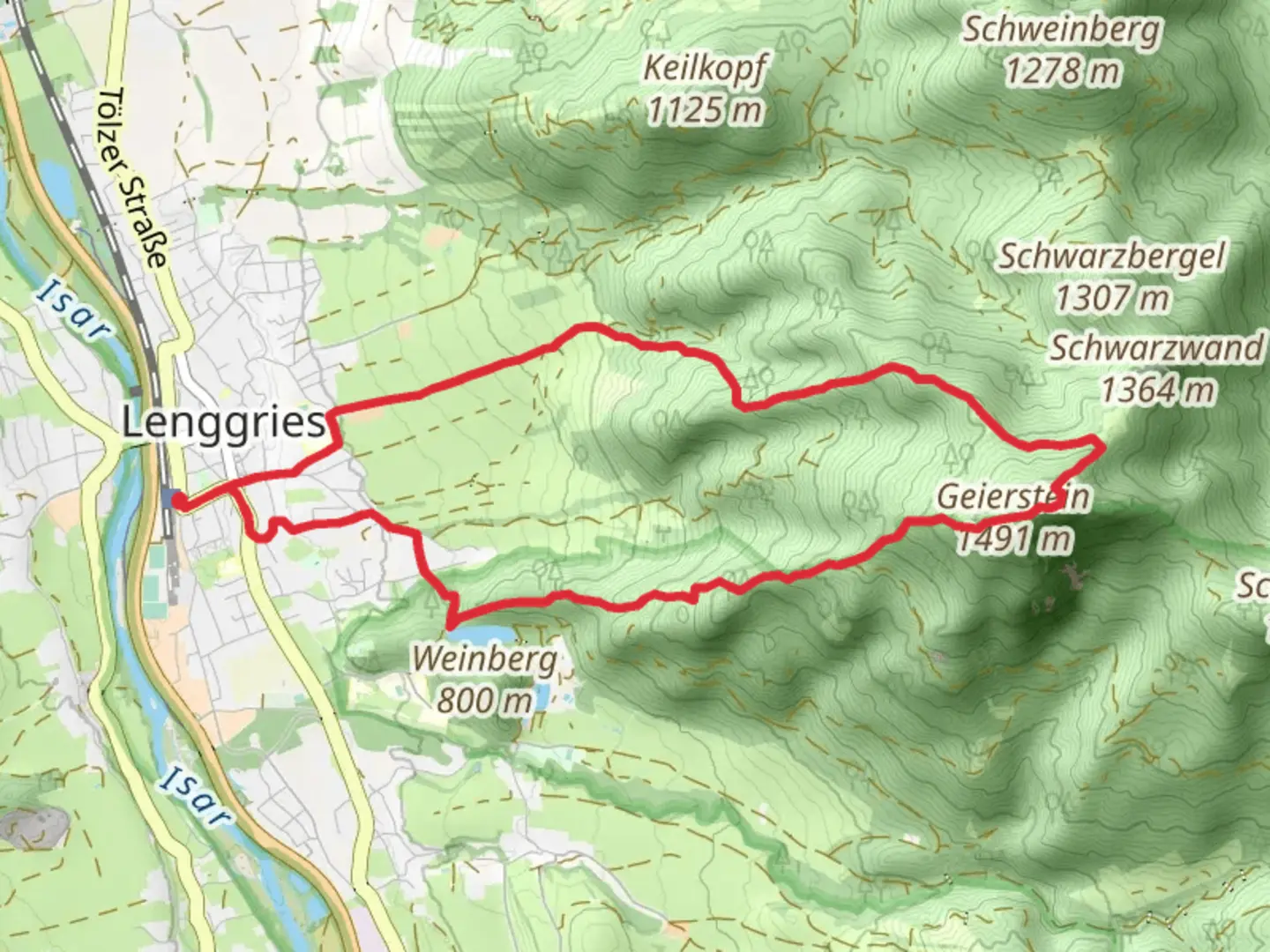
9.6 km
~3 hrs 18 min
827 m
Loop
“Embark on the Geigerstein Peak Loop via Maximiliansweg for a stunning 10 km hike rich in history and natural beauty.”
Starting your adventure near Bad Tölz-Wolfratshausen, Germany, the Geigerstein Peak Loop via Maximiliansweg is a captivating 10 km (6.2 miles) loop trail with an elevation gain of approximately 800 meters (2,625 feet). This medium-difficulty trail offers a blend of natural beauty, historical significance, and a rewarding hiking experience.### Getting There To reach the trailhead, you can either drive or use public transport. If driving, head towards Bad Tölz-Wolfratshausen and look for parking options near the starting point. For those using public transport, take a train to Lenggries station, which is well-connected from Munich. From Lenggries, local buses or a short taxi ride will get you to the trailhead.### Trail Overview The trail begins with a gentle ascent through lush forests, offering a serene start to your hike. As you progress, the path becomes steeper, leading you through a mix of dense woodland and open meadows. Keep an eye out for the diverse flora and fauna; deer, foxes, and a variety of bird species are commonly spotted in this region.### Key Landmarks and Sections - Maximiliansweg Section: Named after King Maximilian II of Bavaria, this part of the trail is historically significant. The king was known for his love of nature and hiking, and this route was one of his favorites. The path here is well-marked and offers stunning views of the surrounding Bavarian Alps.
- Geigerstein Peak: At approximately 5 km (3.1 miles) into the hike, you'll reach the Geigerstein Peak. Standing at an elevation of around 1,850 meters (6,070 feet), this peak offers panoramic views of the Isar Valley and the distant Alps. It's a perfect spot for a break and some memorable photos.- Descent and Loop Completion: The descent from Geigerstein is gradual, taking you through picturesque alpine meadows and back into the forest. The trail loops back to the starting point, completing the 10 km (6.2 miles) journey.### Navigation and Safety For navigation, it's recommended to use the HiiKER app, which provides detailed maps and real-time updates. The trail is well-marked, but having a reliable navigation tool ensures you stay on track.### Flora and Fauna The trail is rich in biodiversity. In spring and summer, the meadows are adorned with wildflowers, including gentians and alpine roses. The forested sections are home to a variety of trees such as spruce, fir, and beech. Wildlife enthusiasts might spot red deer, chamois, and a variety of birds, including the golden eagle.### Historical Significance The region around Bad Tölz-Wolfratshausen has a rich history dating back to Roman times. The Maximiliansweg itself is a tribute to King Maximilian II, who played a significant role in promoting outdoor activities and nature conservation in Bavaria. Hiking this trail offers not just natural beauty but also a connection to the historical and cultural heritage of the area.### Practical Tips
- Weather: The weather in the Bavarian Alps can be unpredictable. Check the forecast before you start and be prepared for sudden changes.
- Gear: Wear sturdy hiking boots and bring layers, as temperatures can vary with elevation. A rain jacket is advisable.
- Hydration and Snacks: Carry enough water and snacks. There are no facilities along the trail, so it's essential to be self-sufficient.
- Wildlife: While encounters with wildlife are rare, it's always good to be aware and respectful of their habitat.This trail offers a perfect blend of natural beauty, historical significance, and a moderately challenging hike, making it a must-visit for outdoor enthusiasts exploring the Bavarian Alps.

What to expect?
Activity types
Comments and Reviews
User comments, reviews and discussions about the Geigerstein Peak Loop via Maximiliansweg - Lenggries, Germany.
4.33
average rating out of 5
6 rating(s)