Download
Preview
Add to list
More
17.0 km
~1 day 0 hrs
1039 m
Loop
“Embark on a 17 km adventure through diverse landscapes and historical landmarks, culminating in stunning Lake District views.”
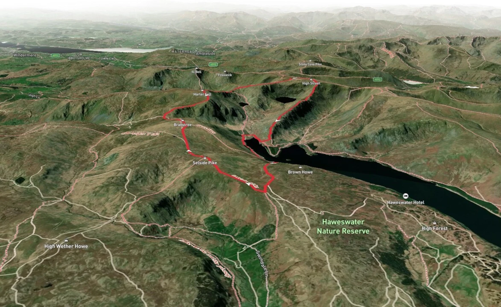
Starting your adventure near Westmorland and Furness, England, this loop trail spans approximately 17 km (10.5 miles) with an elevation gain of around 1000 meters (3280 feet). The trailhead is conveniently accessible by car, with parking available near the village of Mardale Head. For those relying on public transport, the nearest significant landmark is Shap, from where you can take a taxi or local bus services to reach Mardale Head.
Initial Ascent to Selside Pike The journey begins with a steady ascent towards Selside Pike. The initial climb is moderate, gaining about 300 meters (984 feet) over the first 3 km (1.9 miles). The path is well-trodden but can be rocky in places, so sturdy hiking boots are recommended. As you ascend, take in the sweeping views of Haweswater Reservoir to the west, a significant water source for the region.
Traversing to Branstree From Selside Pike, the trail continues towards Branstree, approximately 2.5 km (1.5 miles) away. This section is relatively flat, offering a respite from the initial climb. The terrain here is characterized by grassy moorlands and occasional boggy patches, so waterproof footwear is advisable. Branstree stands at an elevation of 713 meters (2340 feet), providing panoramic views of the surrounding fells.
Mardale Ill Bell and Historical Significance The next leg of the journey takes you to Mardale Ill Bell, about 4 km (2.5 miles) from Branstree. This section involves a descent followed by a steep climb, gaining another 200 meters (656 feet) in elevation. Mardale Ill Bell is a notable peak, offering stunning vistas of the Kentmere Valley. Historically, this area was home to the village of Mardale Green, which was submerged in the 1930s to create the Haweswater Reservoir. Remnants of the village can sometimes be seen when water levels are low.
High Street and Roman Road The final major peak on this loop is High Street, located approximately 3 km (1.9 miles) from Mardale Ill Bell. This section involves a gradual ascent, gaining about 150 meters (492 feet). High Street is historically significant as it follows the route of a Roman road, once used by Roman legions to traverse the region. At an elevation of 828 meters (2717 feet), it is the highest point on this trail, offering expansive views of the Lake District.
Descent and Return to Trailhead From High Street, the trail descends back towards the trailhead at Mardale Head, covering the final 4.5 km (2.8 miles). This descent is steep in places, so trekking poles can be helpful. The path winds through grassy slopes and rocky outcrops, eventually leading you back to the shores of Haweswater Reservoir.
Wildlife and Flora Throughout the hike, keep an eye out for local wildlife, including red deer, peregrine falcons, and the occasional golden eagle. The flora is equally diverse, with heather, bilberry, and various wildflowers adding splashes of color to the landscape.
Navigation and Safety Given the varied terrain and potential for rapidly changing weather conditions, it's advisable to use a reliable navigation tool like HiiKER to stay on track. Ensure you carry sufficient water, snacks, and layers of clothing to adapt to the weather.
This loop trail offers a blend of natural beauty, historical intrigue, and challenging terrain, making it a rewarding experience for hikers of medium difficulty level.

What to expect?
Activity types
Comments and Reviews
User comments, reviews and discussions about the Selside Pike, Branstree, Mardale Ill Bell and High Street Loop, England.
4.0
average rating out of 5
1 rating(s)