Download
Preview
Add to list
More
17.0 km
~4 hrs 7 min
437 m
Loop
“Explore the scenic 17 km Barth Bridge and Brackengill Loop, rich in natural beauty and historical charm.”
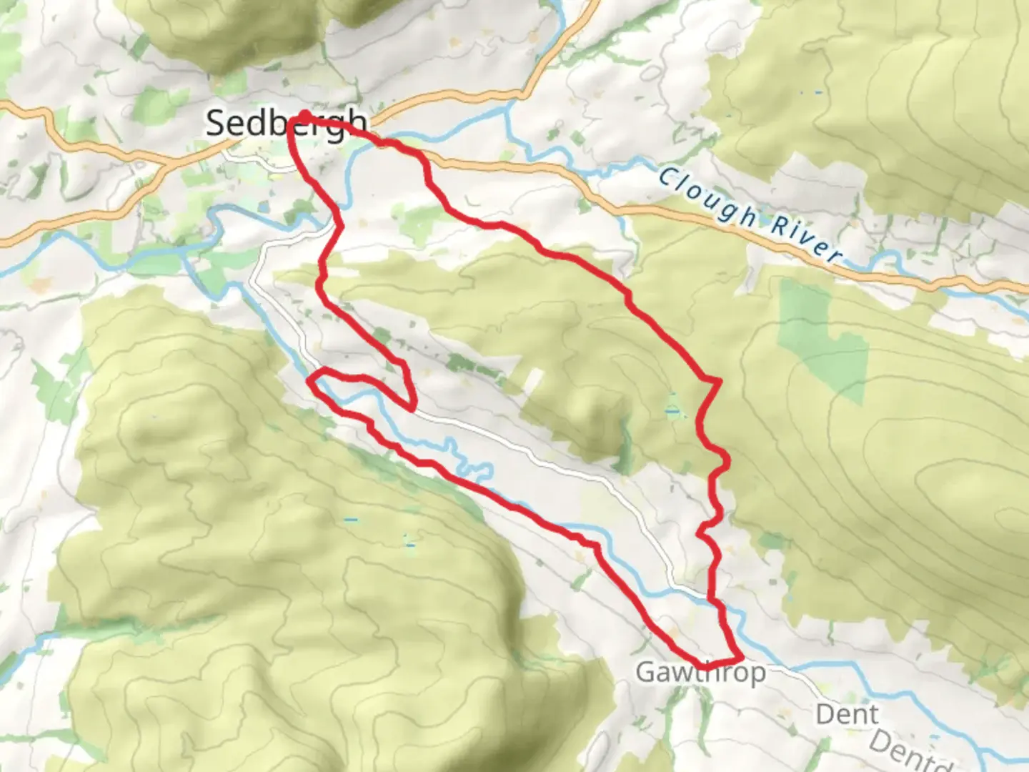
Starting near Westmorland and Furness in England, the Barth Bridge and Brackengill Loop is a captivating 17 km (10.5 miles) loop trail with an elevation gain of approximately 400 meters (1,312 feet). This medium-difficulty trail offers a blend of natural beauty, historical landmarks, and diverse wildlife, making it a rewarding experience for hikers.### Getting There To reach the trailhead, you can drive or use public transport. If driving, set your GPS to the vicinity of Westmorland and Furness. For those using public transport, the nearest significant landmark is the town of Kendal, which is well-connected by train and bus services. From Kendal, you can take a local bus or taxi to the trailhead.### Trail Overview The trail begins near Barth Bridge, a charming stone bridge that dates back to the 18th century. As you start your hike, you'll follow a well-marked path that meanders through lush woodlands and open fields. The initial section is relatively flat, allowing you to ease into the hike while enjoying the serene surroundings.### Key Landmarks and Sections
Barth Bridge to Brackengill
Approximately 5 km (3.1 miles) into the hike, you'll reach Brackengill, a picturesque area known for its rolling hills and scenic views. This section involves a gradual ascent, gaining about 150 meters (492 feet) in elevation. Keep an eye out for local wildlife, including deer and various bird species.#### Brackengill to High Fell Continuing from Brackengill, the trail takes you towards High Fell, the highest point of the loop. This section is about 4 km (2.5 miles) long and involves a steeper climb, adding another 200 meters (656 feet) in elevation. The effort is well worth it, as the summit offers panoramic views of the surrounding countryside. On clear days, you can see as far as the Lake District.#### High Fell to Low Wood Descending from High Fell, the trail leads you through Low Wood, a dense forest area rich in flora and fauna. This 3 km (1.9 miles) section is relatively easy, with a gentle descent of about 100 meters (328 feet). The forest is home to various species of trees, including oak and beech, and is a great spot for birdwatching.### Historical Significance The region around Westmorland and Furness is steeped in history. Barth Bridge itself is a relic from the 18th century, offering a glimpse into the area's past. The trail also passes near several old farmsteads and stone walls, remnants of the agricultural practices that have shaped the landscape over centuries.### Navigation and Safety Given the trail's moderate difficulty, it's advisable to use a reliable navigation tool like HiiKER to stay on track. The path is generally well-marked, but having a digital map can be invaluable, especially in the more remote sections. Ensure you carry enough water, snacks, and appropriate clothing, as weather conditions can change rapidly.### Wildlife and Nature The trail offers a diverse range of habitats, from open fields and rolling hills to dense woodlands. Wildlife enthusiasts will appreciate the opportunity to spot deer, foxes, and a variety of bird species. The flora is equally diverse, with seasonal wildflowers adding splashes of color to the landscape.### Final Stretch The final section of the loop brings you back towards Barth Bridge, completing the 17 km (10.5 miles) journey. This part of the trail is relatively flat and easy, allowing you to cool down as you make your way back to the starting point.This trail offers a perfect blend of natural beauty, historical landmarks, and moderate physical challenge, making it an excellent choice for hikers looking to explore the scenic countryside of Westmorland and Furness.

What to expect?
Activity types
Comments and Reviews
User comments, reviews and discussions about the Barth Bridge and Brackengill Loop, England.
4.4
average rating out of 5
5 rating(s)