Download
Preview
Add to list
More
7.8 km
~1 hrs 41 min
78 m
Loop
“Wander through wildflower meadows and ancient churches, where East Anglia’s peaceful past still lingers.”
Starting from the charming village of Wenhaston, just a short drive from Halesworth in Suffolk, this 8 km (5 miles) loop trail offers a gentle introduction to the rolling countryside of East Anglia, with an elevation gain of about 100 metres (328 feet). The trailhead is conveniently located near the Wenhaston Village Hall, which is easily accessible by car via the A12 and B1123, or by public transport with regular bus services from Halesworth railway station, connecting you to the Greater Anglia rail network.
Getting Oriented and Navigation
Before setting out, download the route on HiiKER for reliable navigation, as some sections cross open fields and woodland where waymarks can be sparse. The loop is well-suited for beginners and families, with mostly flat terrain and only a few gentle inclines as you approach Blythburgh.
Scenery and Landmarks
The path meanders through a patchwork of meadows, ancient hedgerows, and tranquil woodland. Early on, you’ll pass the Wenhaston Doom, a medieval church painting housed in St Peter’s Church, just a few minutes’ walk from the start. This rare artwork dates back to the 16th century and is a highlight for history enthusiasts.
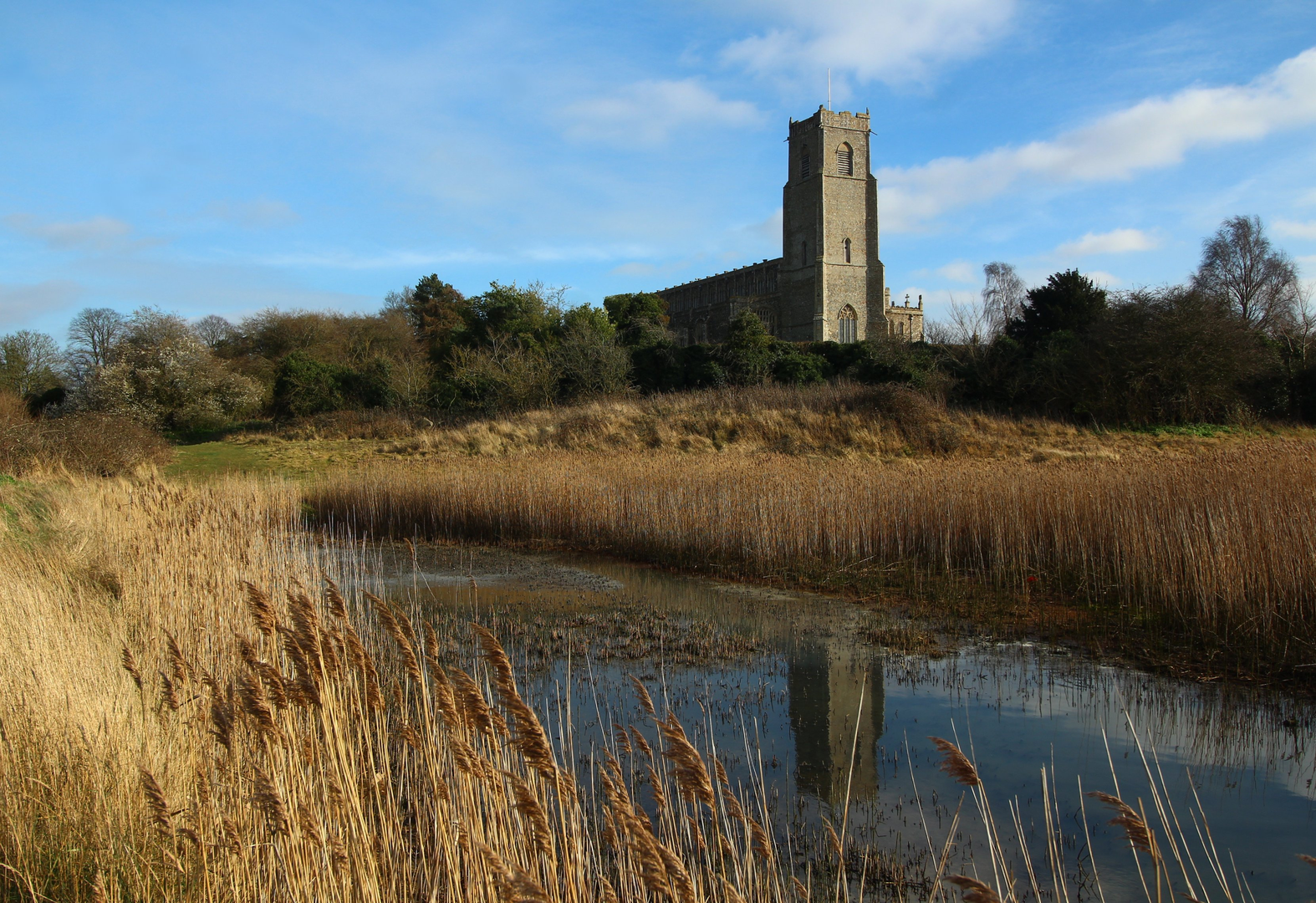
As you continue, the route skirts the edges of the Blyth Valley, offering sweeping views across the marshes and grazing pastures. Around the halfway mark, you’ll reach the historic village of Blythburgh, known for the striking Holy Trinity Church, often called the “Cathedral of the Marshes.” This 15th-century church is visible from afar, its tall tower rising above the flat landscape. Inside, look for the carved wooden angels and medieval graffiti.
Wildlife and Nature
The Blyth Valley is a haven for birdlife, especially in spring and autumn. Keep an eye out for marsh harriers, barn owls, and wading birds along the riverbanks. The hedgerows and meadows are alive with butterflies and wildflowers in summer, while the ancient oaks and alders provide habitat for woodland birds and small mammals.
Trail Conditions and Facilities
The trail follows a mix of quiet country lanes, farm tracks, and grassy footpaths. After rain, some sections can become muddy, so waterproof footwear is recommended. There are no steep climbs, making the route accessible for most walkers, but be prepared for a few stiles and gates. Public toilets and a café can be found in Blythburgh, about 4 km (2.5 miles) into the walk, making it a good spot for a rest before looping back toward Wenhaston.
Historical Context
This region of Suffolk is steeped in history, with evidence of settlement dating back to the Saxon era. Blythburgh itself was once a significant port before the river silted up, and the area’s churches and ancient lanes reflect centuries of rural life. The landscape you traverse has changed little over the years, offering a glimpse into England’s pastoral past.
For a smooth experience, plan your route with HiiKER, check local bus times if arriving by public transport, and bring a camera to capture the timeless scenery and historic landmarks along the way.

What to expect?
Comments and Reviews
User comments, reviews and discussions about the Blythburgh from Wenhaston, England.
3.5
average rating out of 5
2 rating(s)