Download
Preview
Add to list
More
593.2 km
~30 days
9521 m
Multi-Day
“Embark on a timeless 368-mile trek through England's vivid history and landscapes on the Greater Ridgeway Trail.”
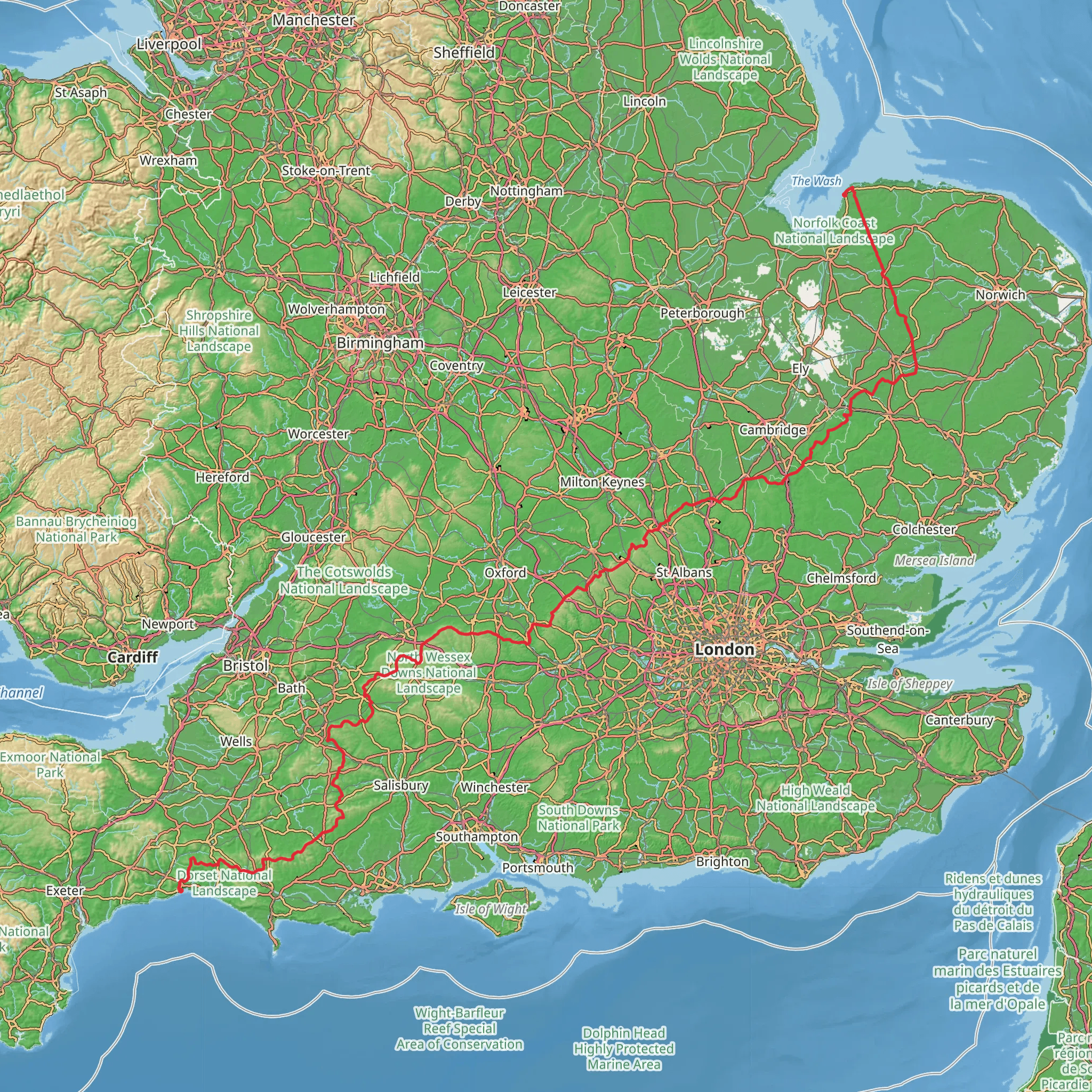
Spanning approximately 368 miles (593 km) with an elevation gain of around 31,200 feet (9500 meters), the Greater Ridgeway Trail is a journey through time, traversing a landscape rich in history and natural beauty. This point-to-point trail begins near the ancient hill fort of Maiden Castle, close to Dorset, England, and stretches all the way to the Norfolk coast at Holme-next-the-Sea.
Getting to the Trailhead
To reach the starting point near Dorset, hikers can use public transport by catching a train to Dorchester, the nearest town with a railway station. From there, local buses or taxis can take you to the vicinity of Maiden Castle, where the trail commences. If driving, parking is available in Dorchester, and you can then make your way to the trailhead.
Historical Significance
The Greater Ridgeway Trail is often referred to as 'the oldest road in Britain,' connecting a series of ancient pathways that have been used for over 5,000 years. As you embark on this journey, you'll encounter Neolithic long barrows, Bronze Age round barrows, Iron Age hill forts, and the remnants of Roman roads, each telling a story of the past inhabitants of this land.
Trail Experience
The trail is divided into four main sections: the Wessex Ridgeway, The Ridgeway National Trail, the Icknield Way, and the Peddars Way. Each offers a unique hiking experience with varying landscapes, from the rolling chalk downs of Wessex to the flat fenlands of East Anglia.
Wessex Ridgeway to The Ridgeway National Trail
Starting near Maiden Castle, the Wessex Ridgeway takes you through the Dorset Area of Outstanding Natural Beauty (AONB) and into Wiltshire. You'll pass through lush woodlands and open fields, with occasional climbs offering panoramic views of the surrounding countryside. After approximately 137 miles (220 km), you'll join The Ridgeway National Trail at Overton Hill.
The Ridgeway National Trail
This 87-mile (140 km) section is known for its historical landmarks, such as the Uffington White Horse, a prehistoric hill figure, and the ancient stone circle at Avebury. The trail here is predominantly along a chalk ridge with expansive views across the Thames Valley and the North Wessex Downs AONB.
Icknield Way
Transitioning into the Icknield Way, the trail becomes less defined and requires careful navigation, which can be assisted by using the HiiKER app. This section is approximately 110 miles (177 km) long and takes you through Bedfordshire and Cambridgeshire, featuring a mix of woodland and heathland.
Peddars Way
The final stretch, Peddars Way, is about 46 miles (74 km) and leads you through the Norfolk countryside to the coast. The terrain here is relatively flat, and the trail ends at the coastal dunes of Holme-next-the-Sea.
Wildlife and Nature
Throughout the Greater Ridgeway Trail, hikers can enjoy a diverse array of flora and fauna. The chalk grasslands are home to a variety of wildflowers and butterflies, while the woodlands provide habitat for birds such as the skylark and yellowhammer. Deer, foxes, and badgers may also be spotted along the route.
Preparation and Planning
Given the trail's length and varied terrain, it's essential to plan your hike carefully. Accommodations range from campsites to B&Bs, and resupply points are available in the towns and villages along the way. Ensure you have appropriate gear for the changing weather conditions and terrain, and consider breaking the hike into manageable sections if you're not planning to complete it in one go.
Remember to respect the natural environment and historical sites you'll encounter on your journey, leaving no trace and preserving the trail for future generations to enjoy.
What to expect?
Activity types
Comments and Reviews
User comments, reviews and discussions about the Greater Ridgeway Trail, England.
3.8
average rating out of 5
5 rating(s)

