Download
Preview
Add to list
More
21.1 km
~4 hrs 32 min
192 m
Point-to-Point
“The Consett to Dunston Walk offers a diverse, historical hike through lush valleys and iconic landmarks.”
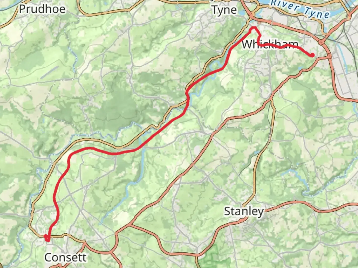
Starting near County Durham, England, the Consett to Dunston Walk spans approximately 21 km (13 miles) with an elevation gain of around 100 meters (328 feet). This point-to-point trail is estimated to be of medium difficulty, making it suitable for moderately experienced hikers.
Getting There To reach the trailhead, you can either drive or use public transport. If driving, head towards Consett, where parking is available near the start of the trail. For those using public transport, buses from Newcastle and Durham frequently service Consett. The nearest significant landmark to the trailhead is the Consett War Memorial Hospital.
Trail Overview The trail begins in Consett, a town with a rich industrial history, particularly known for its steelworks. As you set off, you'll notice remnants of this industrial past, including old railway lines that have been repurposed into walking paths.
Key Landmarks and Sections #### Consett to Lanchester (0-7 km / 0-4.3 miles) The first section of the trail takes you from Consett to Lanchester. This part is relatively flat and easy, making it a good warm-up. Along the way, you'll pass through the picturesque Derwent Valley, known for its lush greenery and diverse birdlife. Keep an eye out for the Derwent Reservoir, a popular spot for birdwatching.
#### Lanchester to Beamish (7-14 km / 4.3-8.7 miles) As you continue, the trail gradually ascends towards Beamish. This section offers a mix of woodland and open fields, providing a variety of landscapes. Beamish is home to the Beamish Museum, an open-air museum that showcases life in the North East of England during the 1820s, 1900s, and 1940s. It's worth taking a short detour to explore this fascinating site.
#### Beamish to Dunston (14-21 km / 8.7-13 miles) The final stretch from Beamish to Dunston involves a gentle descent. This part of the trail offers stunning views of the River Tyne as you approach Dunston. The trail ends near the Dunston Staiths, a significant historical landmark. The Staiths were once the largest wooden structure in Europe, used for loading coal onto ships during the industrial era.
Nature and Wildlife Throughout the trail, you'll encounter a variety of flora and fauna. The Derwent Valley is particularly rich in wildlife, including deer, foxes, and numerous bird species like kingfishers and herons. The woodlands near Beamish are home to red squirrels, a species that has become increasingly rare in the UK.
Navigation and Safety For navigation, it's highly recommended to use HiiKER, which provides detailed maps and real-time updates. The trail is well-marked, but having a reliable navigation tool will ensure you stay on track.
Historical Significance The Consett to Dunston Walk is steeped in history, from the industrial heritage of Consett to the Beamish Museum and the Dunston Staiths. This trail offers a unique opportunity to explore the North East's rich past while enjoying its natural beauty.
Final Tips Wear sturdy hiking boots, as some sections can be muddy, especially after rain. Carry enough water and snacks, as there are limited facilities along the trail. Always check the weather forecast before setting out and dress accordingly.

What to expect?
Activity types
Comments and Reviews
User comments, reviews and discussions about the Consett to Dunston Walk, England.
5.0
average rating out of 5
1 rating(s)