Download
Preview
Add to list
More
11.9 km
~3 hrs 38 min
766 m
Out and Back
“Experience breathtaking views and rich history on the moderate 12 km Summit Peak via Treasure Creek Trail.”
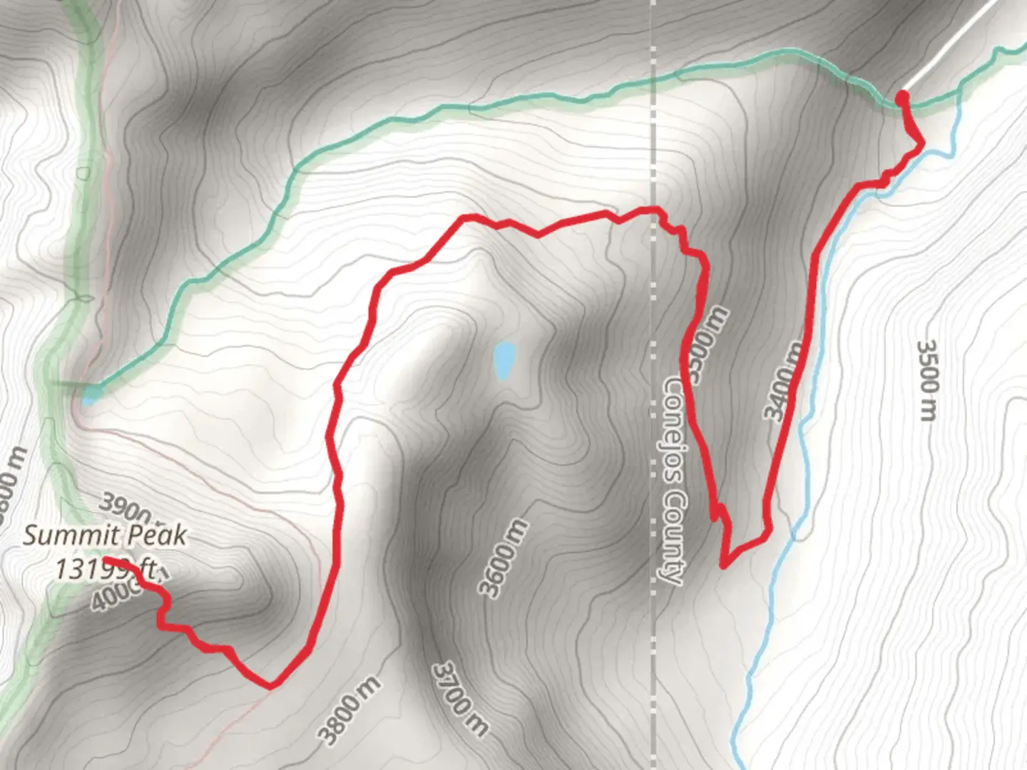
Starting your adventure near Conejos County, Colorado, the Summit Peak via Treasure Creek Trail offers a rewarding out-and-back hike that spans approximately 12 kilometers (around 7.5 miles) with an elevation gain of about 700 meters (2,300 feet). This trail is rated as medium difficulty, making it suitable for moderately experienced hikers.
Getting There To reach the trailhead, you can drive or use public transport. If driving, head towards the nearest significant landmark, Platoro Reservoir, which is accessible via Forest Road 250. From there, follow the signs to the Treasure Creek Trailhead. For those using public transport, the nearest major town is Alamosa, Colorado. From Alamosa, you can take a regional bus service to the town of Antonito and then arrange for a local taxi or shuttle service to the trailhead.
Trail Overview The trail begins at the Treasure Creek Trailhead, located near the scenic Platoro Reservoir. The initial section of the trail is relatively gentle, winding through lush meadows and dense forests of pine and aspen. This area is rich in wildlife, so keep an eye out for deer, elk, and various bird species.
Key Landmarks and Sections - **Treasure Creek Crossing (2 km / 1.2 miles in)**: About 2 kilometers (1.2 miles) into the hike, you'll encounter Treasure Creek. Depending on the season, the water level can vary, so be prepared for a potentially wet crossing. This is a good spot to take a short break and enjoy the serene surroundings. - **Midway Ascent (4 km / 2.5 miles in)**: As you continue, the trail begins to ascend more steeply. Around the 4-kilometer (2.5-mile) mark, you'll start to gain significant elevation. The forest begins to thin out, offering glimpses of the surrounding peaks and valleys.
- Alpine Meadow (6 km / 3.7 miles in): At approximately 6 kilometers (3.7 miles), you'll reach a beautiful alpine meadow. This is a great place to rest and take in the panoramic views. The meadow is often dotted with wildflowers in the summer months, adding a splash of color to the landscape.
Final Ascent to Summit Peak The final push to Summit Peak is the most challenging part of the hike. The trail becomes steeper and rockier as you approach the summit. The last 1.5 kilometers (0.9 miles) involve a series of switchbacks that will test your endurance. However, the effort is well worth it. Upon reaching the summit, you'll be rewarded with breathtaking 360-degree views of the San Juan Mountains and the Rio Grande National Forest.
Historical Significance The region around Conejos County has a rich history. The area was originally inhabited by Native American tribes, including the Ute and Apache. In the late 19th century, it became a hub for miners during the Colorado Gold Rush. Remnants of old mining operations can still be found in the area, adding a historical dimension to your hike.
Navigation and Safety Given the trail's moderate difficulty and varying terrain, it's advisable to use a reliable navigation tool like HiiKER to stay on track. Weather conditions can change rapidly in the mountains, so be prepared with appropriate gear, including layers, a rain jacket, and sturdy hiking boots. Always carry enough water and snacks, and let someone know your hiking plans before you set out.
Embarking on the Summit Peak via Treasure Creek Trail offers not just a physical challenge but also a journey through diverse ecosystems and a glimpse into the historical tapestry of the region.

What to expect?
Activity types
Comments and Reviews
User comments, reviews and discussions about the Summit Peak via Treasure Creek Trail, Colorado.
4.5
average rating out of 5
4 rating(s)