Download
3D Flyover
Add to list
More
644.4 km
~23 days
4133 m
Multi-Day
“Explore the scenic and historic Kettle Valley Rail Trail, a journey through Canada's diverse landscapes and railway heritage.”
Embarking on the Kettle Valley Rail Trail, you'll traverse a historic route that once buzzed with the sounds of locomotives. This expansive trail stretches approximately 644 kilometers (about 400 miles) and ascends roughly 4100 meters (around 13,450 feet) in elevation. As a point-to-point trail, it offers a medium difficulty rating, making it accessible to hikers with a reasonable level of fitness and experience.
Getting to the Trailhead
The trailhead is situated near Central Kootenay, British Columbia. For those driving, you can reach the starting point by navigating towards Midway, BC, which is the eastern terminus of the trail. If you're relying on public transportation, options may be limited, but regional bus services can get you close to the area, where you might need to arrange a taxi or shuttle service to reach the trailhead itself.
Navigating the Trail
As you set out, the HiiKER app will be an invaluable tool for navigation, providing detailed maps and waypoints to guide you along the Kettle Valley Rail Trail. The trail itself is well-marked, following the decommissioned railway line, with gentle grades that rarely exceed a 2.2% incline, a characteristic of its rail heritage.
Historical Significance and Landmarks
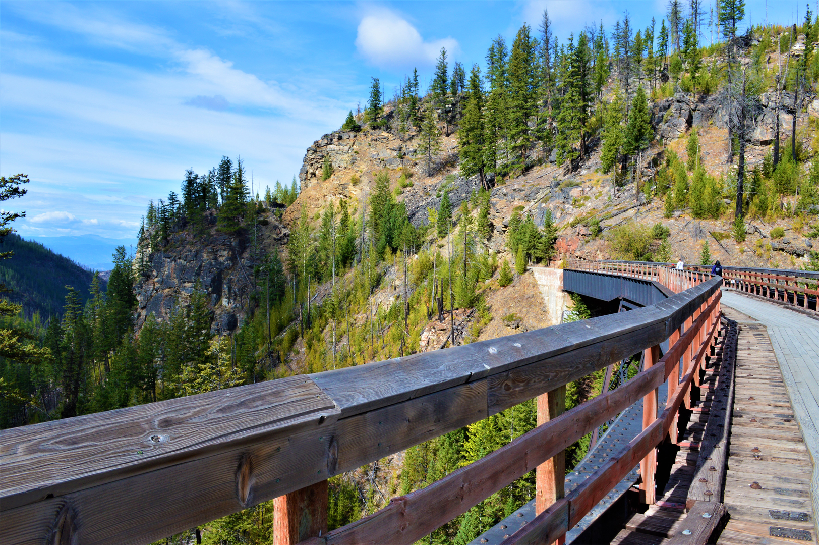
The Kettle Valley Rail Trail is steeped in history, originally constructed as part of the Kettle Valley Railway in the early 20th century. As you hike, you'll encounter remnants of this past, including old train tunnels and trestle bridges that offer a glimpse into the engineering feats of the era. Notable landmarks include the Myra Canyon trestles near Kelowna, which consist of 18 trestle bridges and two tunnels, offering spectacular views and a tangible connection to the trail's railway roots.
Nature and Wildlife
The trail meanders through a diverse range of landscapes, from lush forests and serene lakes to arid desert-like areas. The Myra-Bellevue Provincial Park and Protected Area is a highlight, showcasing the unique ecology of the region. Wildlife is abundant, with chances to spot deer, black bears, and various bird species, so it's important to be aware of your surroundings and knowledgeable about wildlife safety practices.
Preparation and Planning
Given the trail's length, hikers should plan their journey in stages, with options to camp or find accommodation in the small communities along the route. Water sources can be scarce in certain sections, so carrying ample water and a filtration system is crucial. The trail's elevation gain is gradual, but the distance can be taxing, so ensure you're well-prepared with appropriate gear, food, and a first-aid kit.
Seasonal Considerations
The best times to hike the Kettle Valley Rail Trail are from late spring to early fall when the weather is more favorable. Snow can linger in the higher elevations well into the spring, and summer temperatures can soar, especially in the more arid sections, making early morning or late afternoon hikes advisable during the hottest months.
By preparing adequately and respecting the trail's history and natural environment, hikers can enjoy a memorable journey along the Kettle Valley Rail Trail, experiencing the beauty and legacy of this historic Canadian pathway.

What to expect?
Activity types
Frequently asked questions
How long does it take to hike the full Kettle Valley Rail Trail in British Columbia?
The Kettle Valley Rail Trail is 644.42 km long, so a full end-to-end hike is a major multi-day trip rather than a weekend outing. Hiking time depends on pace and resupply planning, but most walkers would need several weeks to cover the entire route from the Midway area across the old rail corridor.
Is the Kettle Valley Rail Trail difficult, and how much climbing is on the route?
The Kettle Valley Rail Trail is rated medium difficulty, with about 4,133 m of total elevation gain over 644.42 km. Its railway heritage keeps most grades relatively gentle compared with mountain trails, so the challenge usually comes more from the long distance and trip logistics than from steep sustained climbing.
What are the best sections of the Kettle Valley Rail Trail for trestles and tunnels?
One of the standout sections of the Kettle Valley Rail Trail is Myra Canyon near Kelowna, where the historic rail bed passes through 16 wood-frame trestles, two steel bridges, and two tunnels in just 8.8 km. This stretch also has 14 viewpoint benches and broad views over the Okanagan Valley, making it one of the most recognizable parts of the route.
Where can you park for the Kettle Valley Rail Trail at Myra Canyon?
For the Myra Canyon section of the Kettle Valley Rail Trail, the main access is from McCulloch Road to Myra Forest Service Road, then 8 km on gravel to a large parking area with roughly 75 spaces and two pit toilets. A second access at June Springs has parking for about 33 vehicles, plus additional pullouts farther along the rail bed.
Are dogs allowed on the Kettle Valley Rail Trail?
Dogs are allowed on parts of the Kettle Valley Rail Trail, but rules vary by section. In Myra-Bellevue Provincial Park, dogs must be kept under control at all times, and in the Myra Canyon area they must be on a leash at all times, so that section is not an off-leash route.
What is the best time of year to hike the Kettle Valley Rail Trail?
Late spring through early fall is generally the most practical time to hike long sections of the Kettle Valley Rail Trail in British Columbia. Some popular sections such as Myra-Bellevue Park are open year-round, but services there typically run from mid-April to November 15, and summer is the busiest season on the trail.
Are there any closures or access issues on the Kettle Valley Rail Trail right now?
Some sections of the Kettle Valley Rail Trail have active access restrictions and construction work, so conditions are not uniform across the full 644.42 km route. In 2026, work has affected parts of the corridor in the Okanagan-Similkameen, including the Adra Tunnel area near Naramata and other sections with traffic controls or temporary closures, so section-by-section planning is important.
Comments and Reviews
User comments, reviews and discussions about the Kettle Valley Rail Trail, British Columbia.
4.88
average rating out of 5
8 rating(s)