Download
3D Preview
Add to list
More
25.1 km
~5 hrs 24 min
229 m
Multi-Day
Havasu Falls Trail
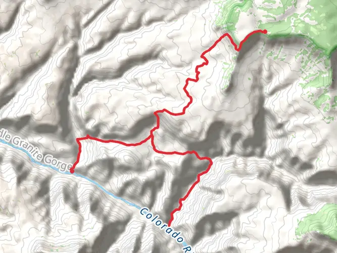
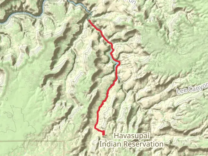
The Havasu Falls Trail is an iconic trek located near Coconino County, Arizona, leading adventurers through the heart of the Havasupai tribal lands to the stunning blue-green waterfalls that have become synonymous with this part of the Grand Canyon. The trail itself is approximately 25 kilometers (15.5 miles) long with an elevation gain of around 200 meters (656 feet), and is classified as a point-to-point hike. Due to the challenging terrain and remote location, it is considered difficult and is best suited for experienced hikers.
Getting There
To reach the trailhead, hikers can drive to Hualapai Hilltop, which is the nearest landmark to the starting point. The hilltop can be accessed by taking Indian Road 18 off of Historic Route 66 between Kingman and Seligman, Arizona. There is a parking area at Hualapai Hilltop, which is the end of the road and the beginning of the Havasu Falls Trail. Public transportation options are limited, so most visitors opt to drive or arrange a shuttle service from nearby cities.
Trail Description
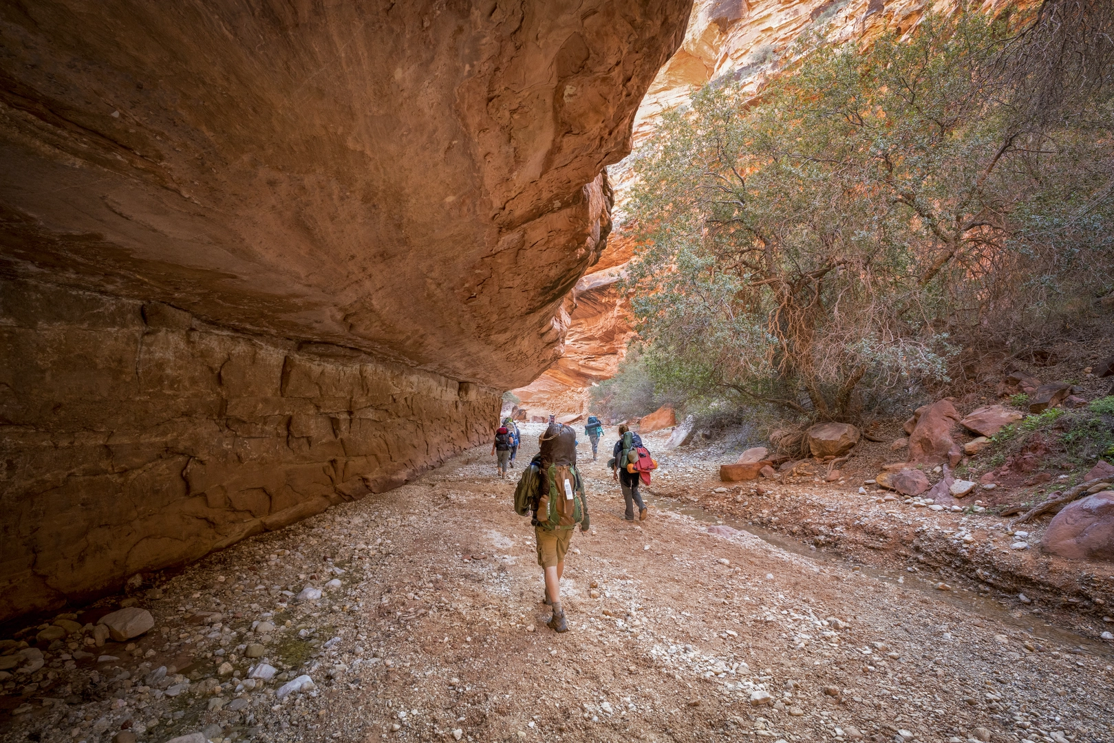
The journey begins at Hualapai Hilltop, where the trail descends steeply for the first 1.6 kilometers (1 mile), dropping into Havasu Canyon. This initial descent is where most of the elevation change occurs. Hikers should be prepared for a series of switchbacks and should proceed with caution, especially when carrying a full pack.
As the trail flattens out, it follows a dry creek bed for about 11.3 kilometers (7 miles) before reaching the village of Supai. This stretch is relatively level but can be hot and arid, so carrying an adequate water supply is crucial. The village of Supai is the only place along the trail where hikers can access amenities such as a cafe, general store, and the local post office, which is famous for being the only one in the United States still delivering mail by mule.
After leaving Supai, the trail continues for another 3.2 kilometers (2 miles) to the campgrounds. Along this section, hikers will get their first glimpse of Havasu Falls, a breathtaking 30-meter (98-foot) waterfall known for its turquoise waters that contrast sharply with the red canyon walls.
Wildlife and Nature
The Havasu Canyon area is home to a variety of wildlife, including mule deer, bighorn sheep, and a diverse array of bird species. The riparian areas along Havasu Creek support lush vegetation, a stark contrast to the surrounding desert landscape. Hikers should be mindful of the delicate ecosystem and adhere to Leave No Trace principles to minimize their impact on the environment.
Historical Significance
The Havasupai people have inhabited the Grand Canyon area for over 800 years, and the trail traverses through their ancestral lands. The name "Havasupai" translates to "people of the blue-green waters," a reference to the vibrant color of the falls and the creek that runs through the canyon. The tribe continues to live in and manage the land, and hikers are guests in this sacred space.
Preparation and Planning
Due to the popularity of the Havasu Falls Trail, permits are required and must be obtained well in advance from the Havasupai Tribe. Hikers should plan their trip carefully, considering the remote nature of the trail and the limited resources available. It is recommended to use a navigation tool like HiiKER to help with planning and staying on the correct path.
Hikers should pack essentials such as a first aid kit, high-energy food, a reliable water filtration system, and appropriate clothing for the season. Camping gear is necessary for overnight stays, and hikers should be prepared for both hot days and cool nights in the canyon.
The Havasu Falls Trail offers a unique and challenging experience for those seeking to explore one of the most picturesque locations in the Grand Canyon. With proper preparation and respect for the land and its people, this hike can be a truly unforgettable adventure.

What to expect?
Activity types
Frequently asked questions
How long is the Havasu Falls Trail and can it be done as a day hike?
The Havasu Falls Trail is about 25.12 km, or 15.5 miles, end to end. It is generally treated as a multi-day hike, and day hiking from Hualapai Hilltop to Supai and the falls is not permitted. The usual hiking distance is about 13 km from Hualapai Hilltop to Supai and roughly 16 km to the campground area.
Where do you park for the Havasu Falls Trail at Hualapai Hilltop?
Parking for the Havasu Falls Trail is at Hualapai Hilltop, the trailhead at the end of Indian Road 18. Parking is limited, with overflow parking sometimes along the road approaching the lot, and vehicles must be registered during check-in for a parking pass. RV parking is especially tight, and some vehicles may end up parked a half mile to a mile from the trailhead.
Do you need a permit for the Havasu Falls Trail and can you visit without a reservation?
A reservation is required for all visits on the Havasupai Reservation, including the Havasu Falls Trail. The route is not an open-access day hike, and visitors need a booking before arrival for either lodging or camping. Standard stays are structured as multi-day trips rather than single-day visits.
Are dogs allowed on the Havasu Falls Trail?
Dogs are not allowed on the Havasu Falls Trail. The Havasupai Tribe does not allow pets, service animals, or privately owned horses anywhere on the reservation, including the trail, campground, lodge, and village areas. That rule applies for the full route from Hualapai Hilltop into Havasu Canyon.
How difficult is the Havasu Falls Trail from Hualapai Hilltop?
The Havasu Falls Trail is rated difficult and covers 25.12 km with about 229 m of elevation gain overall. The hardest early section is the steep descent from Hualapai Hilltop into Havasu Canyon, where the trail drops through switchbacks before flattening along the canyon floor. Its length, heat exposure, and remote setting make it more demanding than the elevation figure alone suggests.
Is there cell service on the Havasu Falls Trail?
Cell service on the Havasu Falls Trail is unreliable. Most of the Havasupai Reservation has little or no dependable cellular reception, including much of the trail as well as the campground and lodge area. Hualapai Hilltop is also remote, so communication should not be planned around having a signal.
Is the Havasu Falls Trail suitable for kids or beginners?
The Havasu Falls Trail is usually better suited to strong, prepared hikers than to beginners. At 25.12 km total, with a difficult rating, a steep opening descent from Hualapai Hilltop, and a remote canyon setting, it can be a tough trip for young children or anyone without experience on long desert hikes. Families that do it successfully usually treat it as a carefully planned multi-day outing.
Comments and Reviews
User comments, reviews and discussions about the Havasu Falls Trail, Arizona.
4.63
average rating out of 5
8 rating(s)