Sprial Butte Trail
Okanogan-Wenatchee National Forest · Yakima County, Washington
16.2 km
~4 hrs 30 min
758 m
“The Spiral Butte Trail in Yakima County rewards hikers with diverse landscapes, historical landmarks, and panoramic views.”
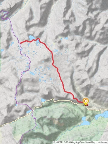
Starting near Yakima County, Washington, the Spiral Butte Trail offers a rewarding 16 km (10 miles) out-and-back hike with an elevation gain of approximately 700 meters (2,300 feet). This medium-difficulty trail is perfect for those looking to experience the diverse landscapes and rich history of the region.
### Getting There To reach the trailhead, you can drive or use public transport. If driving, head towards Yakima County and look for the nearest significant landmark, which is the Yakima Sportsman State Park. From there, follow local signage to the trailhead. For those using public transport, the nearest bus stop is at Yakima Transit Center. From the transit center, you may need to arrange a taxi or rideshare to the trailhead, as public transport options are limited in this rural area.
### Trail Overview The Spiral Butte Trail begins with a gentle ascent through a mixed forest of pine and fir trees. The first 2 km (1.2 miles) are relatively easy, with an elevation gain of about 100 meters (328 feet). This section is a great warm-up and offers a chance to spot local wildlife such as deer and various bird species.
### Mid-Trail Highlights At around the 4 km (2.5 miles) mark, the trail starts to climb more steeply. Here, you'll gain approximately 300 meters (984 feet) in elevation over the next 3 km (1.9 miles). This section is more challenging but offers stunning views of the surrounding valleys and distant mountain ranges. Keep an eye out for the unique rock formations that give Spiral Butte its name.
### Historical Significance As you approach the 7 km (4.3 miles) point, you'll come across remnants of old mining operations from the late 19th century. These historical landmarks offer a glimpse into the region's past and are a great spot for a short break. Informational plaques provide details about the mining history and the people who once worked here.
### Final Ascent and Summit The last 1 km (0.6 miles) to the summit is the most strenuous, with an elevation gain of about 200 meters (656 feet). The trail narrows and becomes rocky, so take your time and watch your footing. Upon reaching the summit, you'll be rewarded with panoramic views of the Yakima Valley and the Cascade Range. This is an excellent spot for photos and a well-deserved rest.
### Wildlife and Flora Throughout the hike, you'll encounter a variety of flora and fauna. In the spring and summer months, wildflowers such as lupine and Indian paintbrush are in full bloom. Wildlife sightings may include black bears, so it's advisable to carry bear spray and make noise to avoid surprising any animals.
### Navigation and Safety Given the trail's moderate difficulty and varying terrain, it's essential to be well-prepared. Use the HiiKER app for accurate navigation and real-time updates on trail conditions. Ensure you have enough water, snacks, and appropriate clothing for changing weather conditions.
### Return Journey The descent follows the same path back to the trailhead. While descending, take the opportunity to enjoy the views you may have missed on the way up. The return journey is generally easier but still requires caution, especially on the steeper sections.
This trail offers a mix of natural beauty, historical interest, and physical challenge, making it a must-visit for hikers in the Yakima County area.
Reviews
User comments, reviews and discussions about the Sprial Butte Trail, Washington.
5.0
average rating out of 5
13 rating(s)


