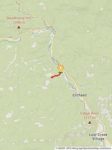
Edgar Rock via Lost Creek Trail
Okanogan-Wenatchee National Forest · Yakima County, Washington
5.5 km
~1 hrs 51 min
452 m
“Embark on Edgar Rock via Lost Creek Trail for a scenic, moderately challenging 6 km hike with stunning views.”
Starting near Yakima County, Washington, the Edgar Rock via Lost Creek Trail is an invigorating out-and-back hike that spans approximately 6 kilometers (around 3.7 miles) with an elevation gain of about 400 meters (approximately 1,312 feet). This trail is rated as medium difficulty, making it suitable for moderately experienced hikers.
### Getting There To reach the trailhead, you can drive or use public transport. If you're driving, head towards the town of Naches, Washington. From Naches, take US-12 W and then turn onto WA-410 W. Continue on WA-410 W until you reach the trailhead near the Lost Creek area. For those using public transport, the nearest significant landmark is the town of Naches, where you can catch a local bus or arrange for a taxi to the trailhead.
### Trail Overview The trail begins with a gentle ascent through a dense forest of Douglas fir and ponderosa pine. This initial section is relatively easy, allowing you to warm up before the more challenging parts of the hike. As you progress, the trail becomes steeper, and you'll start to gain elevation more rapidly.
### Key Landmarks and Points of Interest - Lost Creek: About 1 kilometer (0.6 miles) into the hike, you'll encounter Lost Creek. This is a great spot to take a short break and enjoy the serene sounds of flowing water. The creek is also home to various species of fish and amphibians, so keep an eye out for wildlife. - Wildflower Meadows: Around the 2-kilometer (1.2 miles) mark, the trail opens up into beautiful meadows filled with seasonal wildflowers. Depending on the time of year, you might see lupines, Indian paintbrush, and other vibrant blooms. - Edgar Rock: The highlight of the trail is Edgar Rock, which you'll reach after approximately 3 kilometers (1.9 miles). This massive rock formation offers stunning panoramic views of the surrounding valleys and mountains. The climb to the top of Edgar Rock is steep and requires some scrambling, so be prepared for a bit of a challenge.
### Wildlife and Nature The trail is home to a variety of wildlife, including deer, black bears, and numerous bird species such as woodpeckers and hawks. It's advisable to carry bear spray and make noise while hiking to avoid surprising any wildlife. The flora along the trail is equally diverse, with towering conifers, lush undergrowth, and seasonal wildflowers adding to the scenic beauty.
### Historical Significance The area around Edgar Rock has historical significance dating back to the Native American tribes who originally inhabited the region. The rock itself was used as a lookout point, and the surrounding forests were rich hunting grounds. Later, during the early 20th century, the area saw logging activities, remnants of which can still be seen along the trail.
### Navigation and Safety Given the moderate difficulty of the trail, it's essential to come prepared. Use the HiiKER app for accurate navigation and to stay on track. The trail can be narrow and steep in sections, so good hiking boots with ankle support are recommended. Always carry enough water, snacks, and a first-aid kit. Weather can change rapidly, so layers and a rain jacket are advisable.
This hike offers a rewarding experience with its mix of natural beauty, wildlife, and historical significance. Whether you're looking for a challenging workout or a peaceful escape into nature, the Edgar Rock via Lost Creek Trail has something to offer.
Reviews
User comments, reviews and discussions about the Edgar Rock via Lost Creek Trail, Washington.
4.0
average rating out of 5
11 rating(s)


