10.5 km
~2 hrs 53 min
475 m
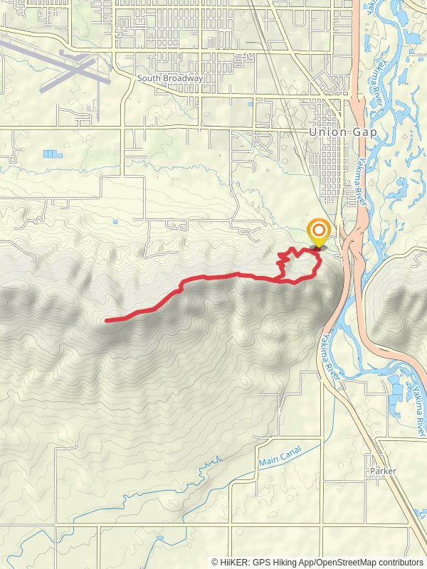
“The Ahtanum Ridge trail in Yakima County offers scenic vistas, diverse landscapes, and rich cultural history in a rewarding 11-kilometer loop.”
Starting near Yakima County, Washington, the Ahtanum Ridge trail offers a scenic loop of approximately 11 kilometers (around 6.8 miles) with an elevation gain of about 400 meters (1,312 feet). This medium-difficulty trail provides a rewarding experience for hikers looking to explore the diverse landscapes of the Pacific Northwest.
### Getting There To reach the trailhead, you can drive or use public transportation. If driving, head towards Yakima County and follow signs to the Ahtanum State Forest. The nearest significant landmark is the Ahtanum Campground, which serves as a convenient starting point. For those using public transport, the nearest bus stop is in Yakima, from where you can take a taxi or rideshare service to the campground.
### Trail Overview The trail begins at the Ahtanum Campground, where you can find parking and basic amenities. As you start your hike, you'll immediately notice the lush forest surroundings, characterized by towering pine and fir trees. The initial section of the trail is relatively flat, making it a good warm-up for the more challenging segments ahead.
### Key Landmarks and Sections - First Kilometer (0.6 miles): The trail meanders through dense forest, offering shade and a cool environment. Keep an eye out for local wildlife such as deer and various bird species. The forest floor is often carpeted with ferns and wildflowers, especially in the spring and early summer. - Second to Fourth Kilometer (1.2 to 2.5 miles): As you progress, the trail begins to ascend more steeply. This section offers panoramic views of the Yakima Valley and the Cascade Range. The elevation gain here is noticeable, so take your time and enjoy the vistas. There are several rocky outcrops that provide excellent photo opportunities.
- Midpoint (5.5 kilometers / 3.4 miles): At the highest point of the trail, you'll reach an open ridge with expansive views. This is a great spot to take a break, have a snack, and soak in the scenery. On clear days, you can see Mount Rainier in the distance.
### Historical Significance Ahtanum Ridge holds historical significance for the indigenous Yakama Nation, who have lived in the region for thousands of years. The area was historically used for hunting and gathering, and you may come across informational plaques that provide insights into the cultural heritage of the Yakama people.
### Final Descent and Return - Sixth to Eighth Kilometer (3.7 to 5 miles): The trail begins to descend gradually, leading you back into the forest. This section can be a bit slippery, especially after rain, so watch your footing. The descent offers a different perspective of the forest, with more opportunities to spot wildlife.
- Last Kilometer (0.6 miles): As you near the end of the loop, the trail flattens out again, guiding you back to the Ahtanum Campground. This final stretch is a good time to reflect on the hike and enjoy the serene forest atmosphere.
### Navigation and Safety For navigation, it's highly recommended to use the HiiKER app, which provides detailed maps and real-time updates. The trail is well-marked, but having a reliable navigation tool ensures you stay on track. Always carry sufficient water, snacks, and a first-aid kit. Weather can change rapidly, so dress in layers and be prepared for varying conditions.
The Ahtanum Ridge trail offers a blend of natural beauty, moderate challenge, and historical context, making it a must-visit for hikers in the Yakima County area.
Reviews
User comments, reviews and discussions about the Ahtanum Ridge, Washington.
5.0
average rating out of 5
13 rating(s)


