Download
Preview
Add to list
More
8.6 km
~2 hrs 20 min
375 m
Out and Back
“This 9 km trail near Glacier, WA, offers panoramic views, rich biodiversity, and historical landmarks.”
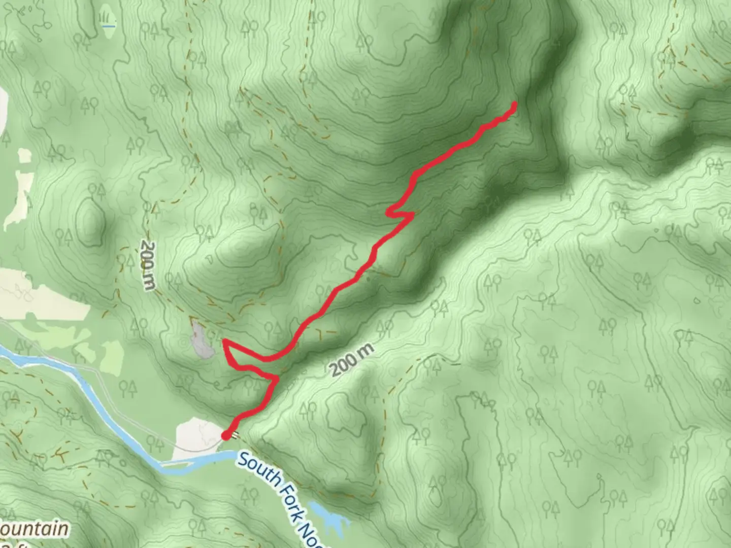
Starting near Whatcom County, Washington, this 9 km (approximately 5.6 miles) out-and-back trail offers a moderate challenge with an elevation gain of around 300 meters (984 feet). The trailhead is accessible by car, with parking available nearby. For those using public transport, the nearest significant landmark is the town of Glacier, Washington, from where you can arrange a taxi or rideshare to the trailhead.### Trail OverviewThe trail begins with a gentle ascent through a lush forest of Douglas fir and western red cedar. The initial 1.5 km (0.9 miles) is relatively easy, allowing hikers to acclimate to the terrain. As you progress, the trail becomes steeper, gaining elevation more rapidly. This section is well-marked, but it's advisable to use HiiKER for navigation to ensure you stay on track.### Significant LandmarksAt around the 3 km (1.9 miles) mark, you'll encounter the Skookum Creek Bridge. This wooden bridge offers stunning views of Skookum Creek below, a perfect spot for a short break and some photos. The creek is known for its crystal-clear waters and, during certain times of the year, you might even spot salmon swimming upstream.Continuing on, the trail meanders through a series of switchbacks, gaining elevation steadily. Around the 5 km (3.1 miles) point, you'll reach the highest elevation of the trail. Here, the forest opens up to reveal panoramic views of the surrounding Whatcom Land. On clear days, you can see as far as the Canadian border to the north and Mount Baker to the south.### Flora and FaunaThe trail is rich in biodiversity. Keep an eye out for native plants like the Pacific trillium and salal. Wildlife is abundant, with frequent sightings of black-tailed deer, and if you're lucky, you might spot a black bear or a bobcat. Birdwatchers will enjoy the variety of species, including the northern flicker and the Steller's jay.### Historical SignificanceWhatcom County has a rich history, with the trail passing through lands that were historically inhabited by the Nooksack Tribe. The area was also a significant site during the logging boom of the late 19th and early 20th centuries. Remnants of old logging equipment and rail lines can still be seen along the trail, offering a glimpse into the region's past.### Final StretchThe return journey retraces your steps back to the trailhead. The descent is easier on the legs but requires careful footing, especially on the steeper sections. The entire hike typically takes around 3-4 hours, depending on your pace and the number of stops you make.### Getting ThereIf driving, take the Mount Baker Highway (SR 542) east from Bellingham, Washington, until you reach Glacier. From Glacier, follow local roads to the trailhead, which is well-signposted. For those relying on public transport, the Whatcom Transportation Authority (WTA) offers bus services to Glacier, where you can then arrange for a taxi or rideshare to the trailhead.This trail offers a rewarding hike with a mix of natural beauty, wildlife, and historical interest, making it a must-visit for anyone in the region.

What to expect?
Activity types
Comments and Reviews
User comments, reviews and discussions about the Skookum Creek Bridge and Whatcom Land, Washington.
4.6
average rating out of 5
10 rating(s)