12.9 km
~3 hrs 49 min
746 m
“Embark on a 13 km Skagit County adventure with lush forests, stunning vistas, and rich history.”
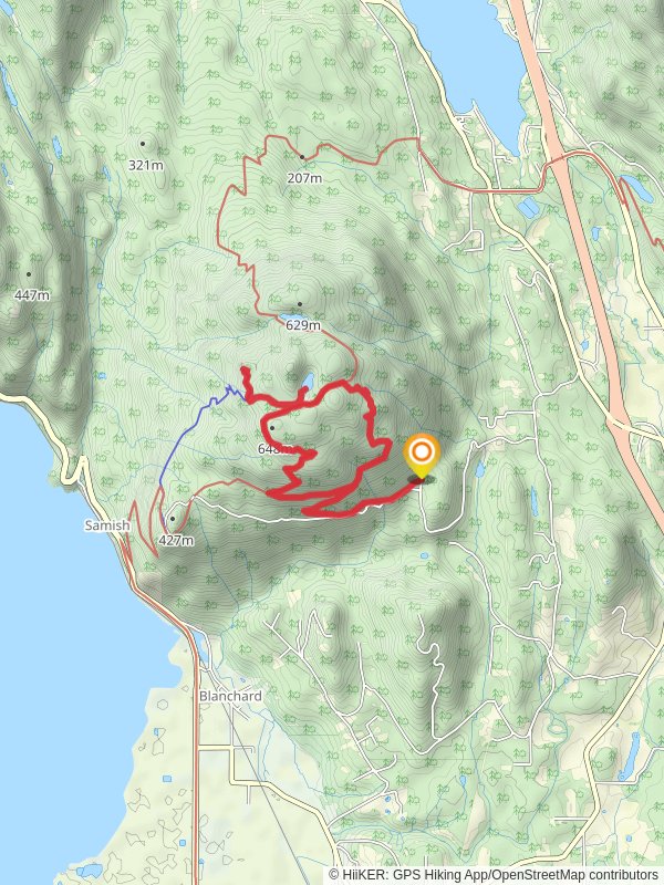
Starting your adventure near Skagit County, Washington, the Lily Lizard, Oyster Dome, and Lily Lake Loop Trail offers a captivating 13 km (8 miles) journey with an elevation gain of approximately 700 meters (2,300 feet). This loop trail is rated medium in difficulty, making it suitable for moderately experienced hikers.
### Getting There To reach the trailhead, you can drive or use public transportation. If driving, head towards the Chuckanut Drive (State Route 11) and look for the trailhead parking area near the Samish Overlook. For those using public transport, the nearest significant landmark is the Chuckanut Park and Ride, from where you can arrange a taxi or rideshare to the trailhead.
### Trail Overview The trail begins with a steady ascent through lush forested areas, where you'll be surrounded by towering Douglas firs and Western hemlocks. The initial 2 km (1.2 miles) of the trail are relatively steep, gaining about 300 meters (1,000 feet) in elevation. This section can be challenging, so take your time and enjoy the serene forest environment.
### Key Landmarks and Points of Interest - Lily Lake: About 4 km (2.5 miles) into the hike, you'll reach Lily Lake. This tranquil spot is perfect for a short break. The lake is surrounded by dense vegetation, and you might spot some local wildlife, including deer and various bird species. - Oyster Dome: Continuing on, around the 6 km (3.7 miles) mark, you'll arrive at the Oyster Dome. This iconic viewpoint offers breathtaking vistas of the Puget Sound and the San Juan Islands. The elevation gain to this point is approximately 500 meters (1,640 feet). It's a popular spot for photos and a well-deserved rest. - Lily Lizard: As you loop back, you'll encounter the Lily Lizard section of the trail. This part is less frequented, providing a more secluded hiking experience. The terrain here is a mix of rolling hills and gentle descents, making it a pleasant contrast to the earlier steep climbs.
### Historical Significance The region around the trail has a rich history. The Chuckanut Drive, which you use to access the trailhead, was originally a route used by Native American tribes. Later, it became a significant road for early settlers and loggers in the area. The Oyster Dome itself is named for the oyster beds that were once abundant in the nearby waters, a nod to the area's maritime heritage.
### Navigation and Safety Given the varied terrain and multiple trail junctions, it's advisable to use a reliable navigation tool like HiiKER to stay on track. The trail is well-marked, but having a digital map can provide extra assurance. Be prepared for changing weather conditions, as the area can be quite damp and foggy, especially in the early morning.
### Wildlife and Flora The trail is home to diverse wildlife, including black bears, so carrying bear spray and making noise while hiking is recommended. The flora is equally impressive, with seasonal wildflowers adding splashes of color to the landscape. Keep an eye out for the vibrant red of the Pacific rhododendron, Washington's state flower.
### Final Stretch The last 3 km (1.9 miles) of the loop trail involve a gradual descent back to the trailhead. This section is less strenuous, allowing you to reflect on the stunning scenery and diverse ecosystems you've encountered. The total elevation gain for the entire loop is around 700 meters (2,300 feet), making it a rewarding yet manageable hike for those prepared for a medium-difficulty trail.
By the time you return to the trailhead, you'll have experienced a rich tapestry of natural beauty, historical significance, and diverse wildlife, all within a single, unforgettable loop trail.
Reviews
User comments, reviews and discussions about the Lily Lizard, Oyster Dome and Lily Lake Loop Trail, Washington.
4.0
average rating out of 5
13 rating(s)


