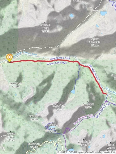
Yellowstone Cliffs via Carbon River Trail
37.9 km
~2 day
1592 m
“Experience a moderately challenging, scenic trek through diverse landscapes to Yellowstone Cliffs in Mount Rainier National Park.”
Starting near Pierce County, Washington, the Yellowstone Cliffs via Carbon River Trail offers a captivating journey through the diverse landscapes of Mount Rainier National Park. This out-and-back trail spans approximately 38 kilometers (24 miles) with an elevation gain of around 1500 meters (4921 feet), making it a moderately challenging hike suitable for those with a good level of fitness.
### Getting There To reach the trailhead, you can drive or use public transportation. If driving, head towards the Carbon River Entrance of Mount Rainier National Park. The nearest significant landmark is the Carbon River Ranger Station, located at 35415 Fairfax Forest Reserve Road East, Carbonado, WA 98323. For those relying on public transport, the closest major city is Seattle. From Seattle, you can take a bus or train to Tacoma, then a local bus to Carbonado, and finally a taxi or rideshare to the ranger station.
### Trail Overview The trail begins at the Carbon River Ranger Station, where you can park your vehicle and gather any last-minute supplies or information. The first section of the trail follows the Carbon River Road, which is closed to vehicles but open to hikers and cyclists. This part of the trail is relatively flat and shaded, making for a gentle start.
### Significant Landmarks and Nature Around 6 kilometers (3.7 miles) in, you'll reach the Old Mine Trail junction. This is a great spot to take a short detour and explore the remnants of an old mining operation, offering a glimpse into the area's historical significance. Continuing on the main trail, you'll soon encounter the Carbon River, a glacial river that provides a stunning backdrop with its milky blue waters.
As you progress, the trail begins to climb more steeply. At approximately 12 kilometers (7.5 miles) from the trailhead, you'll reach the Ipsut Creek Campground. This is a popular spot for overnight camping and a good place to rest and refill your water bottles. The elevation gain becomes more noticeable from here, as the trail ascends through dense forests and past several small waterfalls.
### Wildlife and Flora The trail is rich in wildlife, so keep an eye out for black bears, elk, and various bird species. The flora is equally diverse, with towering Douglas firs, western red cedars, and lush undergrowth of ferns and mosses. During the summer months, the trail is adorned with wildflowers, adding vibrant colors to the landscape.
### Reaching Yellowstone Cliffs The final push to the Yellowstone Cliffs involves a steep ascent, but the effort is well worth it. At around 19 kilometers (11.8 miles) from the trailhead, you'll reach the cliffs, which offer panoramic views of the surrounding valleys and Mount Rainier itself. The cliffs are named for their striking yellowish hue, caused by the presence of sulfur deposits.
### Navigation and Safety Given the trail's length and elevation gain, it's crucial to be well-prepared. Use the HiiKER app for accurate navigation and real-time updates on trail conditions. Ensure you have adequate food, water, and clothing for changing weather conditions. The trail can be muddy and slippery, especially after rain, so sturdy hiking boots are recommended.
### Return Journey The return journey follows the same path back to the Carbon River Ranger Station. While descending, take the time to enjoy the views and perhaps spot any wildlife you may have missed on the way up. The total round trip is approximately 38 kilometers (24 miles), making for a full day or a multi-day adventure, depending on your pace and whether you choose to camp overnight.
This trail offers a blend of natural beauty, historical intrigue, and physical challenge, making it a rewarding experience for those who undertake it.
Reviews
User comments, reviews and discussions about the Yellowstone Cliffs via Carbon River Trail, Washington.
5.0
average rating out of 5
7 rating(s)


