Download
Preview
Add to list
More
13.4 km
~4 hrs 13 min
933 m
Loop
“Embark on a stunning 13 km loop through Mount Rainier's diverse landscapes, from wildflower meadows to alpine lakes.”
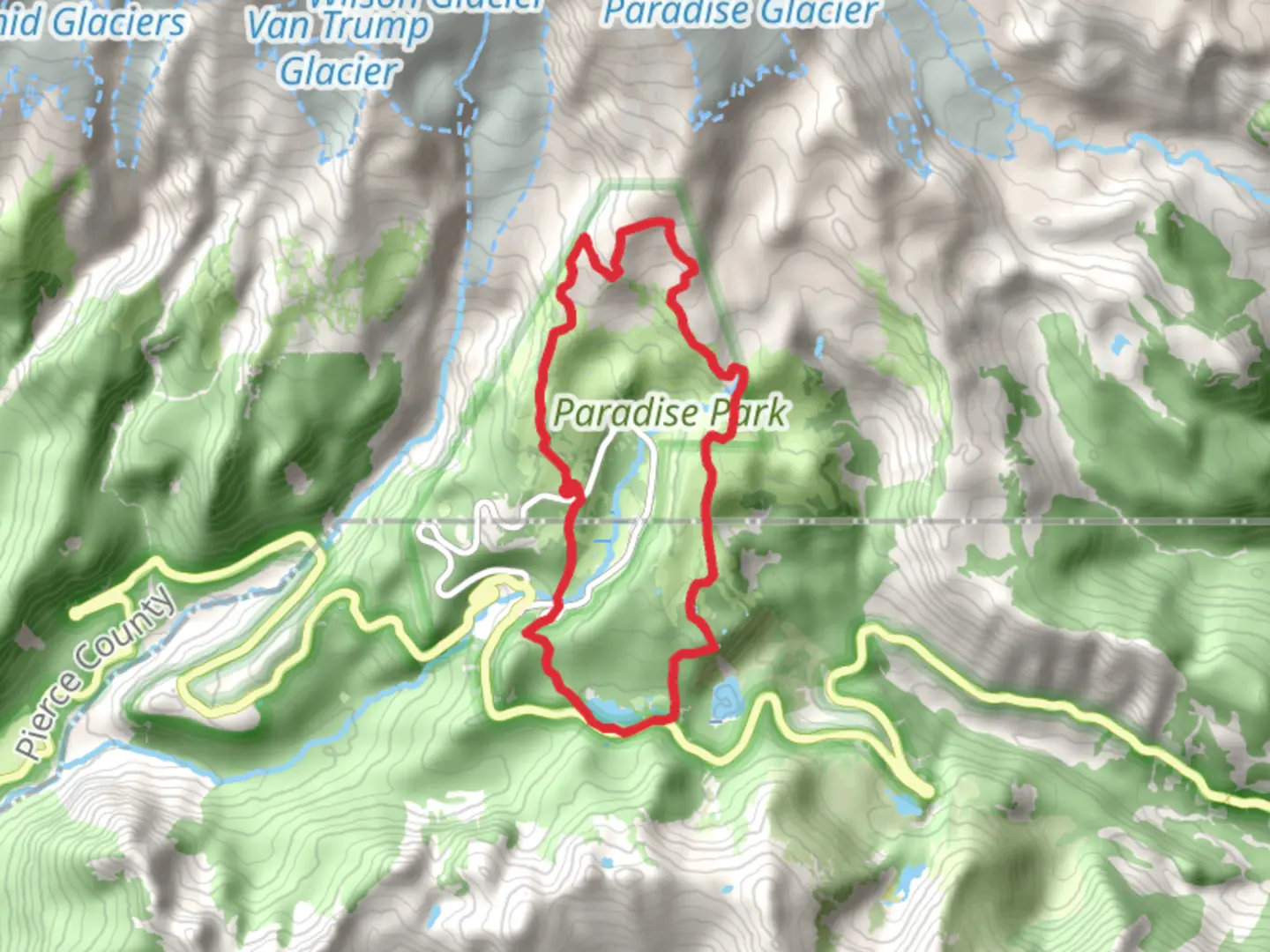
Starting your adventure near Pierce County, Washington, the Skyline Trail and Lower Lakes Trail offer a captivating loop of around 13 km (8 miles) with an elevation gain of approximately 900 meters (2,950 feet). This medium-difficulty trail is perfect for those looking to experience the diverse beauty of the Pacific Northwest.
Getting There To reach the trailhead, you can drive or use public transportation. If driving, head towards the Paradise area in Mount Rainier National Park. The nearest significant landmark is the Paradise Inn, located at 52807 Paradise Rd E, Ashford, WA 98304. For those using public transport, you can take a bus to Ashford and then a shuttle service to Paradise.
Trail Overview The loop begins near the Paradise Inn, where you can find ample parking and restroom facilities. The trailhead is well-marked, and you’ll start your journey with a gradual ascent through lush meadows filled with wildflowers during the summer months.
Key Sections and Landmarks
#### Ascending to Panorama Point The first significant landmark is Panorama Point, located about 3.2 km (2 miles) from the trailhead. This section involves a steady climb, gaining approximately 300 meters (1,000 feet) in elevation. The views from Panorama Point are breathtaking, offering a panoramic vista of Mount Rainier and the surrounding valleys. On clear days, you can even see as far as Mount St. Helens and Mount Adams.
#### Crossing Pebble Creek Continuing from Panorama Point, the trail becomes a bit more challenging as you cross Pebble Creek. This section is rocky and can be slippery, so good hiking boots are essential. The creek crossing is about 4.8 km (3 miles) into the hike, and you’ll gain another 150 meters (500 feet) in elevation.
#### Reaching the Skyline Trail Junction At around 6.4 km (4 miles), you’ll reach the junction with the Skyline Trail. Here, you can take a short detour to the Muir Snowfield if you’re up for an additional challenge. Otherwise, continue on the Skyline Trail, which will start to descend gradually.
Wildlife and Flora The trail is abundant with wildlife. Keep an eye out for marmots, mountain goats, and occasionally black bears. The meadows are home to a variety of wildflowers, including lupines, Indian paintbrush, and avalanche lilies. Birdwatchers will also enjoy spotting species like the Clark’s nutcracker and the mountain bluebird.
Historical Significance Mount Rainier National Park, established in 1899, is one of the oldest national parks in the United States. The Paradise area has a rich history, with the Paradise Inn itself being a historic landmark built in 1916. The area was named by early settlers who were struck by its beauty, and it has been a popular destination for hikers and nature lovers ever since.
Descending via the Lower Lakes Trail As you descend, you’ll transition onto the Lower Lakes Trail. This section is less strenuous and offers serene views of alpine lakes and dense forests. The trail meanders through the forest for about 4.8 km (3 miles) before looping back towards the Paradise area.
Navigation and Safety Given the elevation and potential for sudden weather changes, it’s crucial to be prepared. Use HiiKER for real-time navigation and trail updates. Always carry a map, compass, and sufficient water. Weather can be unpredictable, so layers and rain gear are advisable.
By the time you complete the loop, you’ll have experienced some of the most stunning landscapes that Mount Rainier National Park has to offer.

What to expect?
Activity types
Comments and Reviews
User comments, reviews and discussions about the Skyline Trail and Lower Lakes Trail, Washington.
4.47
average rating out of 5
17 rating(s)