11.0 km
~2 hrs 38 min
257 m
“The Beaver Creek Loop is a scenic, moderately challenging 11 km trail rich in natural beauty and history.”
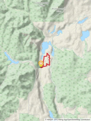
Starting near Pend Oreille County, Washington, the Beaver Creek Loop is a scenic 11 km (approximately 6.8 miles) trail with an elevation gain of around 200 meters (656 feet). This loop trail offers a moderate challenge, making it suitable for hikers with some experience.
### Getting There To reach the trailhead, you can drive or use public transport. If driving, head towards the town of Newport, Washington. From Newport, take Highway 20 north for about 15 miles (24 km) until you reach the junction with Flowery Trail Road. Turn right onto Flowery Trail Road and continue for approximately 5 miles (8 km) until you reach the trailhead parking area near the Beaver Creek Campground. For those using public transport, the nearest significant landmark is Newport, where you can catch a local bus or arrange for a taxi to take you to the trailhead.
### Trail Overview The Beaver Creek Loop begins at the Beaver Creek Campground, a convenient starting point with ample parking and basic amenities. As you set off, the trail meanders through dense forests of Douglas fir and ponderosa pine, providing ample shade and a serene atmosphere. The first 2 km (1.2 miles) are relatively flat, making for an easy warm-up.
### Significant Landmarks and Nature Around the 3 km (1.9 miles) mark, you'll encounter the first significant landmark: a picturesque wooden bridge crossing Beaver Creek. This is an excellent spot for a short break and some photos. Continuing on, the trail gradually ascends, offering glimpses of the surrounding mountains and valleys. Keep an eye out for local wildlife, including deer, elk, and various bird species.
### Elevation Gain and Scenic Views The most challenging part of the hike comes between the 5 km and 7 km (3.1 to 4.3 miles) marks, where the trail climbs steadily, gaining about 150 meters (492 feet) in elevation. This section rewards you with stunning panoramic views of the Selkirk Mountains and the lush valleys below. Make sure to bring a camera to capture these breathtaking vistas.
### Historical Significance The region around Beaver Creek has a rich history, with evidence of Native American habitation dating back thousands of years. The trail itself follows some of the old routes used by the Kalispel Tribe for hunting and gathering. Interpretive signs along the way provide insights into the historical and cultural significance of the area.
### Navigation and Safety Given the moderate difficulty of the trail, it's advisable to use a reliable navigation tool like HiiKER to stay on track. The trail is well-marked, but having a digital map can be invaluable, especially in areas where the path may be less distinct.
### Final Stretch The final 4 km (2.5 miles) of the loop are a gentle descent back towards the trailhead, passing through meadows and alongside the creek. This section is particularly beautiful in the spring and early summer when wildflowers are in full bloom.
### Wildlife and Flora Throughout the hike, you'll be surrounded by a diverse array of flora and fauna. In addition to the towering pines and firs, look for wildflowers such as lupine and Indian paintbrush. Wildlife sightings are common, so keep your eyes peeled for signs of black bears, coyotes, and various bird species, including eagles and hawks.
### Preparation Tips Given the moderate difficulty and the elevation gain, it's essential to come prepared. Wear sturdy hiking boots, bring plenty of water, and pack some snacks or a light lunch. Weather can be unpredictable, so dressing in layers is advisable. Always check the local weather forecast before setting out and let someone know your hiking plans.
The Beaver Creek Loop offers a rewarding hike with a mix of natural beauty, historical significance, and moderate physical challenge, making it a must-visit for outdoor enthusiasts in the Washington area.
Reviews
User comments, reviews and discussions about the Beaver Creek Loop, Washington.
0.0
average rating out of 5
0 rating(s)


