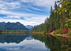
Red Mountain Trail
Okanogan-Wenatchee National Forest · Kittitas County, Washington
7.0 km
~3 hrs 8 min
1049 m
“The Red Mountain Trail offers a rugged 7 km hike with rich history and stunning Pacific Northwest views.”
Starting your adventure near Kittitas County, Washington, the Red Mountain Trail offers a moderately challenging hike with a total distance of around 7 km (4.3 miles) and an elevation gain of approximately 1000 meters (3280 feet). This out-and-back trail is perfect for those looking to experience the rugged beauty of the Pacific Northwest.
### Getting There To reach the trailhead, you can drive or use public transport. If driving, head towards the town of Cle Elum, Washington. From there, take the WA-903 N and follow signs towards Salmon La Sac. The trailhead is located near the Salmon La Sac Campground, which is a well-known landmark in the area. For those using public transport, the nearest bus stop is in Cle Elum, from where you can arrange a taxi or rideshare to the trailhead.
### Trail Overview The trail begins at an elevation of about 700 meters (2296 feet) and quickly ascends through dense forest. The initial 2 km (1.2 miles) are relatively steep, gaining about 400 meters (1312 feet) in elevation. This section is shaded and offers a cool, refreshing start to your hike. Keep an eye out for Douglas firs and western hemlocks, which dominate the landscape.
### Mid-Trail Highlights As you reach the 3 km (1.9 miles) mark, the trail opens up to a series of switchbacks. Here, the elevation gain becomes more gradual, and you’ll start to see stunning views of the surrounding valleys and peaks. This is a great spot to take a break and hydrate. The switchbacks continue for another 1 km (0.6 miles), gaining an additional 300 meters (984 feet) in elevation.
### Wildlife and Flora The Red Mountain Trail is home to a variety of wildlife. Deer and elk are commonly spotted, especially in the early morning or late afternoon. Birdwatchers will enjoy sightings of woodpeckers, jays, and occasionally, eagles. The flora changes as you ascend, with alpine meadows appearing near the higher elevations. During late spring and early summer, these meadows are blanketed with wildflowers, including lupines and Indian paintbrush.
### Historical Significance The region around Red Mountain has a rich history. It was originally inhabited by the Yakama Nation, who used the area for hunting and gathering. In the late 19th and early 20th centuries, the area saw an influx of miners searching for gold and other minerals. Remnants of old mining equipment can still be found near the trail, adding a historical dimension to your hike.
### Final Ascent and Summit The final 1 km (0.6 miles) to the summit is the most challenging part of the hike, with a steep incline gaining the last 300 meters (984 feet) in elevation. The trail becomes rocky and less defined, so it’s essential to have a reliable navigation tool like HiiKER to stay on track. Upon reaching the summit, you’ll be rewarded with panoramic views of the Cascade Range, including Mount Rainier and Mount Stuart on clear days.
### Descent The descent follows the same path back to the trailhead. While descending, take your time to enjoy the views and perhaps spot some wildlife you missed on the way up. The steep sections can be tough on the knees, so trekking poles are recommended for added stability.
### Preparation Tips Given the elevation gain and the rugged terrain, it’s crucial to be well-prepared. Wear sturdy hiking boots, bring plenty of water, and pack layers as the weather can change rapidly. A map and compass or a reliable navigation app like HiiKER are essential for staying on course.
The Red Mountain Trail offers a rewarding hike with diverse landscapes, rich history, and stunning views, making it a must-visit for any hiking enthusiast.
Reviews
User comments, reviews and discussions about the Red Mountain Trail, Washington.
4.0
average rating out of 5
7 rating(s)


