Download
Preview
Add to list
More
11.5 km
~4 hrs 6 min
1083 m
Loop
“Embark on a challenging yet rewarding 12 km hike through lush forests with stunning panoramic views and historical landmarks.”
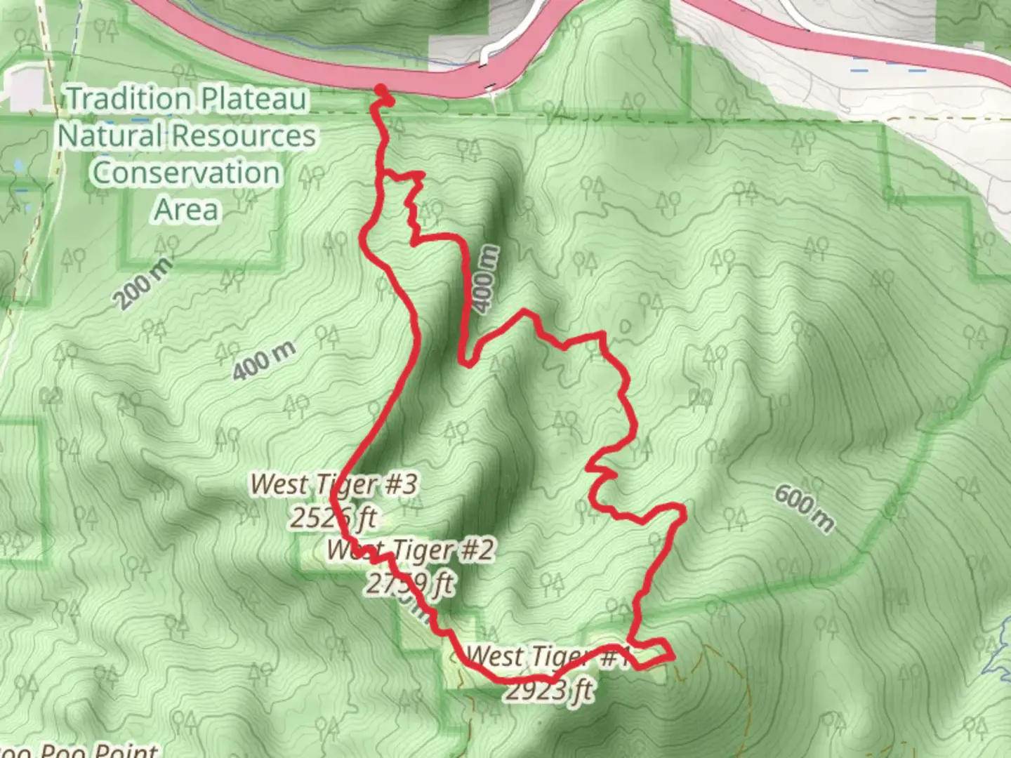
Starting your adventure near King County, Washington, the Cable Line and West Tiger 3, 2, and 1 Loop Trail offers a challenging yet rewarding experience. This 12 km (7.5 miles) loop trail features an elevation gain of approximately 1000 meters (3280 feet), making it a medium difficulty hike suitable for those with a moderate level of fitness.### Getting There To reach the trailhead, you can drive or use public transport. If driving, head towards the Issaquah Alps, specifically the Tiger Mountain State Forest. The nearest significant landmark is the High Point Trailhead, located off Exit 20 on I-90. For those using public transport, King County Metro Transit provides bus services to Issaquah, from where you can take a short taxi or rideshare to the trailhead.### Trail Overview The trail begins with the Cable Line Trail, a steep and direct ascent that quickly gains elevation. This section is known for its rigorous climb, so be prepared for a strenuous start. The trail is well-marked, but using a navigation tool like HiiKER can help ensure you stay on track.### Key Sections and Landmarks - Cable Line Trail to West Tiger 3: The initial 2 km (1.2 miles) of the Cable Line Trail is the most challenging, with an elevation gain of about 610 meters (2000 feet). This section is steep and can be slippery, especially after rain. Trekking poles are highly recommended.
- West Tiger 3 Summit: At approximately 3 km (1.9 miles) into the hike, you'll reach the summit of West Tiger 3. Here, you'll find a radio tower and a small clearing that offers panoramic views of the surrounding area, including Mount Rainier on clear days.- Connecting to West Tiger 2 and 1: From West Tiger 3, the trail continues to West Tiger 2 and then to West Tiger 1. This section is less steep but still involves some elevation gain. The distance between West Tiger 3 and West Tiger 1 is about 2.5 km (1.5 miles), with an additional elevation gain of 200 meters (656 feet).- West Tiger 1 Summit: The highest point on the trail, West Tiger 1, offers expansive views and is a great spot for a rest. The summit is marked by another radio tower and a bench where you can take in the scenery.### Flora and Fauna The trail winds through dense forests of Douglas fir, western hemlock, and red cedar. In spring and summer, the underbrush is adorned with ferns, salal, and huckleberries. Wildlife sightings are common, including black-tailed deer, various bird species, and occasionally black bears. Always carry bear spray and know how to use it.### Historical Significance Tiger Mountain has a rich history, once being a significant area for logging in the early 20th century. Remnants of old logging equipment and railroads can still be found along the trail, offering a glimpse into the region's past.### Descent and Return The descent begins from West Tiger 1, looping back towards the trailhead. This section is less steep but can be rocky and uneven. The total distance back to the trailhead is about 4.5 km (2.8 miles), with a descent of approximately 610 meters (2000 feet).### Preparation Tips
- Weather: The weather can change rapidly, so bring layers and waterproof gear.
- Water and Snacks: Carry sufficient water and high-energy snacks.
- Footwear: Sturdy hiking boots with good traction are essential.
- Navigation: Use HiiKER for real-time navigation and trail updates.This trail offers a mix of challenging climbs, rewarding views, and a rich natural and historical landscape, making it a must-visit for any hiking enthusiast.

What to expect?
Activity types
Comments and Reviews
User comments, reviews and discussions about the Cable Line and West Tiger 3, 2, and 1 Loop Trail, Washington.
4.76
average rating out of 5
17 rating(s)