Download
Preview
Add to list
More
31.1 km
~1 day 3 hrs
1663 m
Out and Back
“Explore lush forests, stunning peaks, and historical landmarks on the moderately challenging Park Creek Pass trail.”
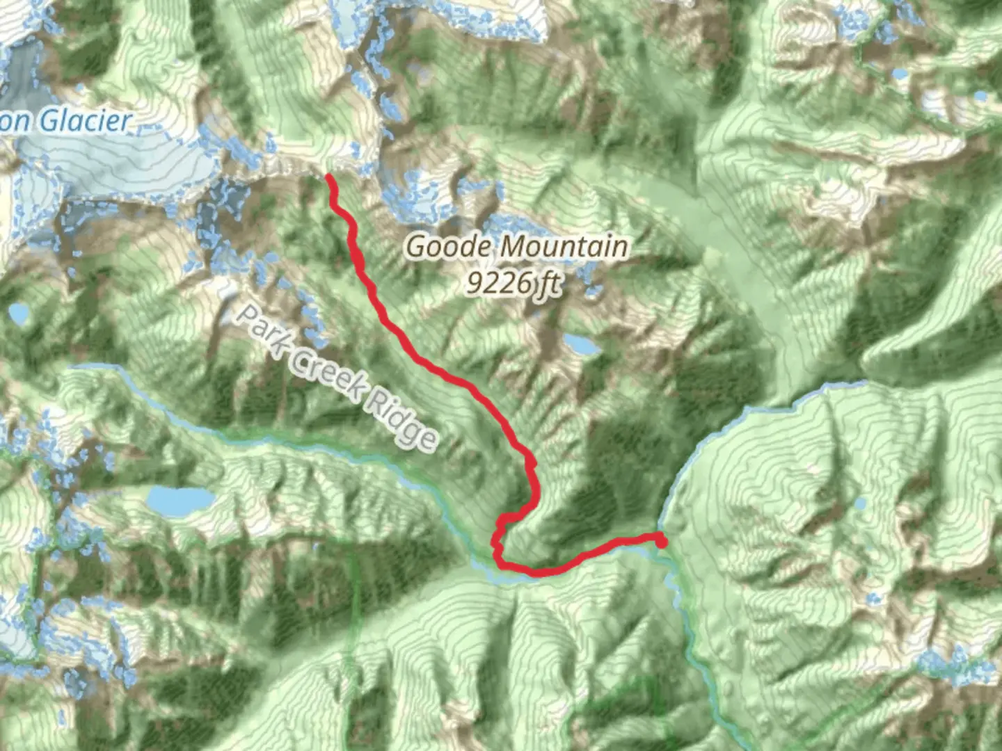
Starting near Chelan County, Washington, the Park Creek Pass via Upper Stehekin Valley Trail is an out-and-back trail that spans approximately 31 kilometers (19.3 miles) with an elevation gain of around 1600 meters (5,249 feet). This trail is rated as medium difficulty, making it suitable for moderately experienced hikers.
Getting There To reach the trailhead, you can drive or use public transportation. If driving, head towards the town of Chelan, Washington. From there, take the Lady of the Lake ferry to Stehekin, a remote community accessible only by boat, plane, or foot. Once in Stehekin, you can take a shuttle bus to the High Bridge Trailhead, which is the starting point for this hike.
Trail Overview The trail begins at the High Bridge Trailhead, located near the Stehekin River. The initial section of the trail is relatively flat, following the Stehekin Valley Road for about 4 kilometers (2.5 miles) before transitioning into a more rugged path. As you hike along the Stehekin River, you'll be surrounded by lush forests of Douglas fir and western red cedar, providing ample shade and a serene atmosphere.
Significant Landmarks and Elevation At around 6 kilometers (3.7 miles) into the hike, you'll reach the junction with the Bridge Creek Trail. Continue straight to stay on the Upper Stehekin Valley Trail. The trail gradually ascends, and you'll start to notice the elevation gain as you approach the 10-kilometer (6.2-mile) mark. Here, the forest begins to thin out, offering stunning views of the surrounding peaks, including Goode Mountain and Storm King.
Wildlife and Flora The area is rich in wildlife, so keep an eye out for black bears, deer, and various bird species. The trail is also known for its vibrant wildflower displays in late spring and early summer, featuring lupines, Indian paintbrush, and columbines.
Historical Significance The Stehekin Valley has a rich history, with evidence of Native American habitation dating back thousands of years. The name "Stehekin" itself is derived from a Salishan word meaning "the way through," reflecting the valley's historical role as a travel route. In the late 19th and early 20th centuries, the area saw a brief mining boom, remnants of which can still be seen along the trail.
Reaching Park Creek Pass As you continue, the trail becomes steeper, particularly in the last 5 kilometers (3.1 miles) leading up to Park Creek Pass. This section is the most challenging, with switchbacks and rocky terrain. However, the effort is well worth it. Upon reaching Park Creek Pass, located at an elevation of approximately 1,829 meters (6,000 feet), you'll be rewarded with panoramic views of the North Cascades, including peaks like Buckner Mountain and Booker Mountain.
Navigation and Safety Given the trail's remote location, it's crucial to be well-prepared. Download the trail map from HiiKER for offline use, as cell service is limited. Carry sufficient water, food, and emergency supplies. Weather can change rapidly in the mountains, so pack layers and be prepared for sudden temperature drops.
Return Journey The return journey follows the same path back to the High Bridge Trailhead. While descending, take the time to enjoy the different perspectives and perhaps spot some wildlife you may have missed on the way up.
This trail offers a mix of natural beauty, historical significance, and a moderate challenge, making it a rewarding experience for those who undertake it.

What to expect?
Activity types
Comments and Reviews
User comments, reviews and discussions about the Park Creek Pass via Upper Stehekin Valley Trail, Washington.
4.67
average rating out of 5
6 rating(s)