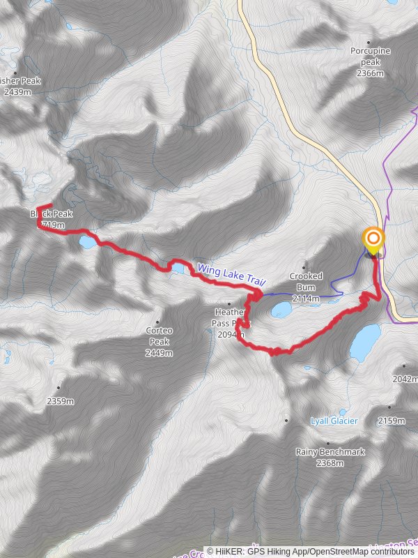
Black Peak, Wing Lake and Lewis Lake via Rainy Lake Trail
24.9 km
~1 day 4 hrs
2755 m
“This trail offers serene lakes, challenging ascents, and breathtaking views, perfect for experienced hikers in the North Cascades.”
Starting your adventure near Chelan County, Washington, the trailhead for this hike is conveniently located near the Rainy Pass on the North Cascades Highway (Highway 20). If you're driving, you can park at the Rainy Pass Picnic Area. For those relying on public transport, the nearest major town is Winthrop, where you can catch a shuttle service to the trailhead during the hiking season.
### Initial Ascent and Rainy Lake The journey begins with a relatively gentle ascent through dense forest, leading you to Rainy Lake after about 2 km (1.2 miles). This serene alpine lake, surrounded by towering peaks, is a great spot for a quick rest and some photos. The elevation gain here is minimal, around 150 meters (492 feet), making it an easy warm-up for the more challenging sections ahead.
### Climbing to Wing Lake Continuing past Rainy Lake, the trail becomes steeper and more rugged as you ascend towards Wing Lake. This section covers approximately 8 km (5 miles) with an elevation gain of about 1,000 meters (3,280 feet). The path is well-marked but can be rocky and uneven, so sturdy hiking boots are recommended. Along the way, you'll traverse alpine meadows filled with wildflowers in the summer months and might spot marmots and mountain goats.
### Wing Lake and Black Peak Upon reaching Wing Lake, situated at an elevation of around 2,200 meters (7,218 feet), you'll be greeted by stunning views of Black Peak. This glacial lake, with its crystal-clear waters, is an ideal spot for a longer break. From here, the trail to Black Peak becomes more challenging, involving some scrambling and route-finding. Using a navigation tool like HiiKER can be particularly helpful in this section. The summit of Black Peak offers panoramic views of the North Cascades, making the effort well worth it.
### Descent to Lewis Lake After soaking in the views from Black Peak, retrace your steps back to Wing Lake and then head towards Lewis Lake. This section is less traveled and can be a bit tricky to navigate, so keep your HiiKER app handy. The descent to Lewis Lake covers about 3 km (1.9 miles) with a drop of around 300 meters (984 feet). Lewis Lake is another beautiful alpine lake, perfect for a peaceful moment before you begin your return journey.
### Return Journey The return journey follows the same path back to the Rainy Pass trailhead. The total distance for this out-and-back hike is around 25 km (15.5 miles) with a cumulative elevation gain of approximately 2,700 meters (8,858 feet). Given the length and elevation gain, this hike is rated as medium difficulty, suitable for experienced hikers with good physical fitness.
### Historical Significance The North Cascades region, where this trail is located, has a rich history. It was originally inhabited by Native American tribes such as the Skagit and Nlaka'pamux, who used these trails for hunting and trading. The area later became significant during the gold rush era in the late 19th century, attracting miners and settlers. Today, it is preserved as part of the North Cascades National Park, offering a glimpse into both natural beauty and historical heritage.
### Wildlife and Flora Throughout the hike, keep an eye out for the diverse wildlife that inhabits the North Cascades. You might encounter black bears, deer, and various bird species. The flora is equally impressive, with old-growth forests, alpine meadows, and a variety of wildflowers, especially vibrant in late spring and early summer.
This trail offers a mix of serene lakes, challenging ascents, and breathtaking views, making it a must-do for any avid hiker exploring the North Cascades.
Black Peak, Wing Lake and Lewis Lake via Rainy Lake Trail passes through these parks:
Reviews
User comments, reviews and discussions about the Black Peak, Wing Lake and Lewis Lake via Rainy Lake Trail, Washington.
5.0
average rating out of 5
9 rating(s)


